#NCwx #ElizabethCity #HurricaneErin #Erin
1/2
From PASQUOTANK-CAMDEN Emergency Management on FB: 𝗛𝗨𝗥𝗥𝗜𝗖𝗔𝗡𝗘 𝗘𝗥𝗜𝗡 𝗕𝗥𝗜𝗘𝗙𝗜𝗡𝗚 #𝟯
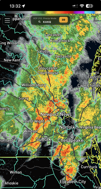
As of the 11am NOAA NWS National Hurricane Center and US National Weather Service Wakefield VA updates, Hurricane Erin is currently located about 365 miles SSE of Cape Hatteras. Erin is currently a category 2 storm with sustained winds of 110mph and moving North at 13mph. Erin appears to be re-strengthening over warmer waters and expected to return to a Category 3 storm by 8pm this evening. The forecast track remains confident that a turn towards the northeast will occur in the next 36 hours. A Tropical Storm Warning has been issued for the Albemarle Sound due to very rough waters and a 40-70% chance of tropical storm force winds. Residents along the southern ends of Pasquotank and Camden Counties should prepare to experience these conditions.
𝑳𝒐𝒄𝒂𝒍 𝑭𝒐𝒓𝒆𝒄𝒂𝒔𝒕 𝒂𝒔 𝒐𝒇 𝟏𝟏𝒂𝒎
𝙏𝙞𝙢𝙚𝙡𝙞𝙣𝙚: Erin is expected to begin impacting our area after midnight tonight with impacts ending by early Friday morning
𝙒𝙞𝙣𝙙: 17-25mph sustained winds beginning after midnight tonight with gusts of 28-40+ mph from 7am Thursday through 1am Friday. Winds will be from the North/Northeast.
𝙍𝙖𝙞𝙣: 0.25” expected with the greatest chance on Thursday evening
𝙁𝙡𝙤𝙤𝙙𝙞𝙣𝙜: Minor flooding may occur in low lying areas however due to the NNE winds, we are not forecasted to receive much inundation.
𝙎𝙚𝙫𝙚𝙧𝙚 𝙒𝙚𝙖𝙩𝙝𝙚𝙧: Slight chance of Thunderstorms Thursday evening. Very slight chance of Tornadoes