BakersRelay will be following #HurricaneErin as the outer bands of the storm reach North Carolina Outer Banks, and the Virginia Beach, Suffolk, Hampton Roads, Norfolk area of Virginia. If I start to overwhelm your feed with information please feel free to Mute or Block me.
#NCwx #VAwx #DareCounty #CarteretCounty #Erin
BakersRelay will be following Hurricane #Erin as the outer bands of the storm reach North Carolina Outer Banks, and the Virginia Beach, Suffolk, Hampton Roads, Norfolk area of Virginia. If I start to overwhelm your feed with information please feel free to Mute or Block me.
#NCwx #VAwx #DareCounty #CarteretCounty
BakersRelay signing off for the night. If you wish to continue following Hurricane Erin posts follow one or more of the addresses/hashtags below.
@easwatch
#NCwx
#VAwx
#HurricaneErin
#Erin
#DareCounty
#CarteretCounty
#SevereWeather
#NCwx #CarteretCounty #HurricaneErin #Erin
3/3
Carteret County Emergency Services will continue to share updates from the National Weather Service as the situation develops. Residents are urged to follow guidance from trusted sources, including the National Hurricane Center at www.hurricanes.gov and the National Weather Service at www.weather.gov/mhx. Local updates will be posted on the county website, social media channels, and shared with local media outlets. For preparedness resources, visit www.carteretcountync.gov or call 252-222-5841.
The next update from Carteret County Emergency Services will be issued no later than Wednesday, August 20, at 4:00 p.m.
#NCwx #CarteretCounty #HurricaneErin #Erin
2/3
The strongest winds are expected Wednesday evening through Thursday afternoon, with gusts near tropical-storm strength possible along the immediate coast and adjacent sounds. Persistent north to northeast winds could continue, creating the potential for soundside flooding in Down East areas through Friday.
Beach and water conditions will be hazardous throughout the week. Life-threatening rip currents and extremely dangerous surf are expected, with large breaking waves peaking midweek and lingering into Friday. Residents and visitors are strongly advised to monitor the beach flag system. Red flags indicate high hazard, and double red flags mean the water is closed to swimming altogether. Everyone is urged to respect these warnings and avoid entering the water until conditions improve.
Carteret County officials encourage residents to review and complete their preparations as soon as possible. Emergency kits should be stocked with essential items, important documents secured, and pets included in planning. Outdoor furniture, trash cans, and other loose items should be brought inside or otherwise secured. Drivers are reminded to never attempt to cross flooded roadways. Turn around, don’t drown. Power outages are possible, so residents should charge devices, check on neighbors who may need assistance, stay informed, and remain vigilant throughout this storm and during future storms.
#NCwx #CarteretCounty #HurricaneErin #Erin
From Carteret County Government on FB: UPDATE #4
1/3
NEWS RELEASE: Carteret County Prepares for Hurricane Erin Impacts
CARTERET COUNTY, N.C. (Aug. 19, 2025) – Carteret County officials continue to monitor Hurricane Erin as it moves up the Atlantic coast. While the storm is expected to remain offshore, it is a large system, and its effects will be felt well beyond the center. Residents can anticipate the potential for higher water levels along the coast, stronger winds, rough surf, beach erosion, and hazardous rip currents beginning this afternoon and continuing through Thursday. County officials are working closely with local, state, and federal partners to coordinate response and ensure the community is prepared.
The National Weather Service office in Newport/Morehead City reports that coastal flooding may begin with today’s high tide, more than 24 hours before tropical-storm-force winds arrive. A Tropical Storm Warning is now in effect for Down East Carteret County, including the adjacent ocean and sound waters along the entire county coastline. A Storm Surge Warning is in effect for Down East Carteret County for the likelihood of up to two to three feet of inundation above normally dry areas along the oceanside and low-lying areas near the water. A Coastal Flood Warning is also in effect for all of Carteret County.
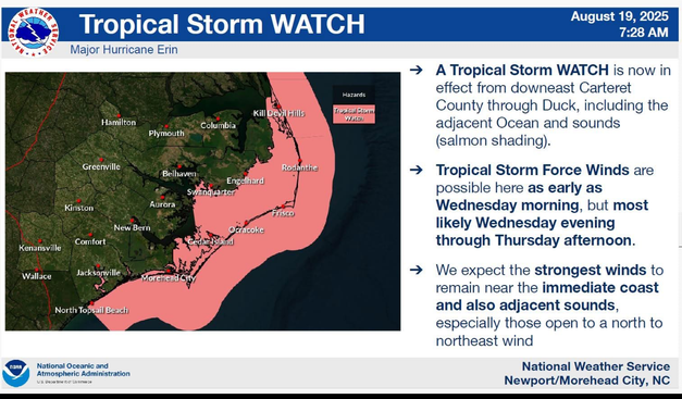
From #CarteretCounty Government on FB: A Tropical Storm Watch is in effect for Down East Carteret County, including adjacent ocean waters and sounds, as of 5 p.m. Monday, Aug. 18. This means tropical storm conditions are possible within the next 48 hours.
@easwatch #NCwx #HurricaneErin #Erin #OBX #EAS #WEA for East #CarteretCounty: National Weather Service: A STORM SURGE WARNING is in effect for this area for the danger of life-threatening flooding. This warning is issued up to 36 hours before hazardous conditions begin. Urgently complete efforts to protect life and property. Follow evacuation orders if given for this area to avoid drowning or being cut off from emergency services. Source: NWS Newport/Morehead City NC ** DO NOT RELY ON THIS FEED FOR LIFE SAFETY, SEEK OUT OFFICIAL SOURCES ***
Bobby V Hancock in North Carolina: Name: Bobby V Hancock
State: North Carolina
Agency: Carteret County Sheriff
Decertified Since: 1997 https://copblaster.com/cop/11263/bobby-v-hancock?utm_source=dlvr.it&utm_medium=mastodon #BobbyVHancock #CarteretCounty #DeputySheriff #LawEnforcement #NorthCarolina
State: North Carolina
Agency: Carteret County Sheriff
Decertified Since: 1997 https://copblaster.com/cop/11263/bobby-v-hancock?utm_source=dlvr.it&utm_medium=mastodon #BobbyVHancock #CarteretCounty #DeputySheriff #LawEnforcement #NorthCarolina