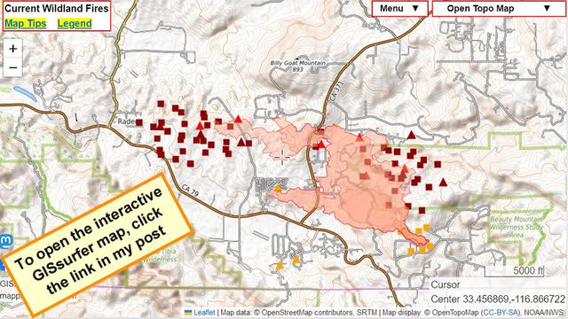
#California #RiversideCounty #DAT #HighlandFire #Aguanga #Animals

#AnimalRescue > Some donations are welcome and needed at the animal shelter in #Temecula (California Ranch Company):
hay, feed and supplies needed for horses, pigs, goats, chickens, etc.

Olive Oil Ranch at the corner 79 & 371 had to turn animals loose during the #HighlandFire last night.

It's believed that most of the animals are still at the ranch and are okay.

Please keep your eyes open for free-roaming animals in or near the fire area.

#RiversideCounty #RivCo #Aguanga

https://m.facebook.com/story.php?story_fbid=pfbid033gyh7rdYzf7uyqtMZhNqpuUq5LDkBwBFAEpTA5P1Hq2q56bjQmu8L9u17T21ms9Sl&id=100009557691594&sfnsn=mo

#highlandfire #Aguanga #RiversideCounty

Animal evac resources

#Animal Shelter:
San Jacinto Animal Shelter
581 S. Grand Ave, San Jacinto

California Ranch Company
43101 Anza Road, Temecula 92592
310-261-1739

Pet shelter:
Great Oak High School
32555 Deer Hollow Way, Temecula

Evac Assistance:
> https://www.facebook.com/groups/158954694272977/?ref=share

> https://www.facebook.com/groups/1518109305132610/?ref=share

#HighlandFire - Additional EVACUATION ORDER issued for the following area(s):

North of San Diego County line
South of Highway 79
East of Forest Route 8S07
West of Crosley Truck Trail

The fire has grown overnight to 2,200 acres and remains 0% contained.

A Reception and Care Center has opened at:
Great Oak High School 32555 Deer Hollow Way, Temecula, Ca 92592

Large and small animals can be taken to:
San Jacinto Animal Shelter 581 South Grand Avenue, San Jacinto, Ca 92582

#Aguanga #RiversideCounty #California #RivCo

October 31 5:30am
Interactive #GIS map for #HighlandFire, #Aguanga area Riverside County California.

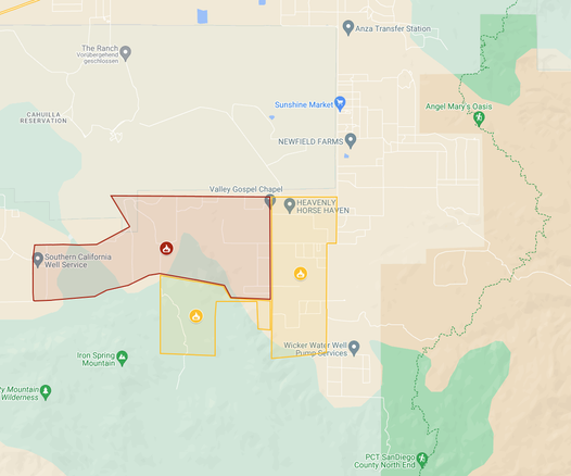
Map will always show the latest perimeter from the FIRIS system, assuming that data has been uploaded to the GIS server they are using. At the time of my post the perimeter was determined as of 12:51am today (subtract 7 hours to convert from UTC time) and the fire was 1,640 acres at that time.

Open #GISsurfer map:
https://mappingsupport.com/p2/gissurfer.php?center=33.450704,-116.869297&zoom=13&basemap=Open_Topo_Map&overlay=State_boundary,MODIS_7_day,VIIRS_7_day,FIRIS_Fire_perimeter&data=https://mappingsupport.com/p2/special_maps/disaster/USA_wildland_fire.txt

GISsurfer General Purpose Web Map and GIS Viewer | Surf GIS DATA

GISsurfer lets you surf a nearly endless amount of GIS data. Click a layer in the GIS server's table of contents and that data appears on the map.

#Highlandfire - #Aguanga #RiversideCounty - Evac info;

Palomar Inn Temecula can accommodate up to 13 evacuees tonight. If you need shelter: 951-676-6503

RCAS staff is still on site at the San Jacinto Valley Animal Campus. No call needed for animal evacuees.

Emergency only: 911

Interactive #GIS map for #HighlandFire, #Aguanga area Riverside County California.

Dark red triangles and squares are MODIS and VIIRS satellite heat detections in prior 6 hours. This data is *not* real time and locations are only approximate. Never rely on any map to ignore an order to evacuate.

To learn about heat detection data click "Map tips" upper left corner.
#CAwx #CAfire

Open #GISsurfer map:
https://mappingsupport.com/p2/gissurfer.php?center=33.440946,-116.847153&zoom=13&basemap=Open_Topo_Map&overlay=State_boundary,USA_roads,MODIS_7_day,VIIRS_7_day&data=https://mappingsupport.com/p2/special_maps/disaster/USA_wildland_fire.txt

GISsurfer General Purpose Web Map and GIS Viewer | Surf GIS DATA

GISsurfer lets you surf a nearly endless amount of GIS data. Click a layer in the GIS server's table of contents and that data appears on the map.

#BonnyFire - #Aguanga #RiversideCounty #California
has been mapped at 877 acres and is down to 5% containment due to high temperatures and the wind .
All evacuation orders and warnings remain in place.

#BonnyFire [Bonny Lane, #Aguanga, #RivCo / #california

... early awakening.

If you live near the fire ... stay safe and informed.

#Bonnyfire > #Aguanga, #RiversideCounty, #California

EVACUATION ORDER:
S of Bailey
W of Chapman
N of Running Springs
E of Bonny Ln

EVACUATION WARNING:
S of Tulle Peak & Ramsey
W of Terwilliger
E & N of Forestry Boundary

EVACUATION CENTER:
Hamilton High School, 57430 Mitchell Road, Anza 92539 (pet-friendly)

#Animals > The Anza Lions Arena is open for evacuations at 39551 Kirby Road, Anza.
Evacuation POC: Chris Skinner 951-526-9406