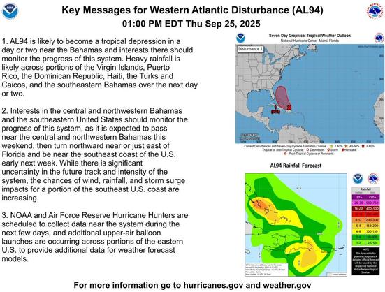
NWS: AL94 is likely to become a tropical depression in a day or two near the Bahamas and interests there should monitor the progress of this system. Heavy rainfall is likely across portions of the Virgin Islands, Puerto Rico, the Dominican Republic, Haiti, the Turks and Caicos, & the southern Bahamas. 👇
2 PM Thursday Sep 25 Update: Here are Key Messages associated with the disturbance (#AL94) located over the western Atlantic. The system is likely to become a tropical depression in a day or two near the Bahamas. Interests in the Bahamas and along the southeast U.S. coast should monitor the progress of this system. Follow the latest at http://hurricanes.gov https://x.com/NHC_Atlantic/status/1971267883520098788
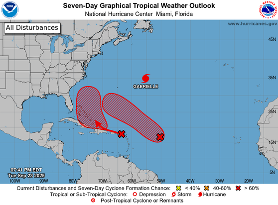
@NHC_Atlantic: 8p EDT Tues 9/23- We are monitoring 2 disturbances that are likely to become tropical depressions this week. The western one #AL94 could form near the Bahamas in a few days, with a heavy rain threat for the Lesser Antilles, Puerto Rico and the Dominican Republic during the next couple of days. The eastern system #AL93 is likely to become a depression in a couple of days, but stay north of the Leeward Islands. Finally Hurricane Watches are up for Hurricane G https://x.com/NHC_Atlantic/status/1970638241247187073
from National Hurricane Center (@NHC_Atlantic X/Twitter)
【 915am EDT Oct 19th -- A special Tropical Weather Outlook has been issued on #AL94, which now has a high chance to become a Tropical Depression or Storm (90% 🔴) as soon as later this morning.
👇
https://www.nhc.noaa.gov/gtwo.php?basin=atlc&fdays=2 】
↑
https://x.com/nhc_atlantic/status/1847634579181490281?s=46
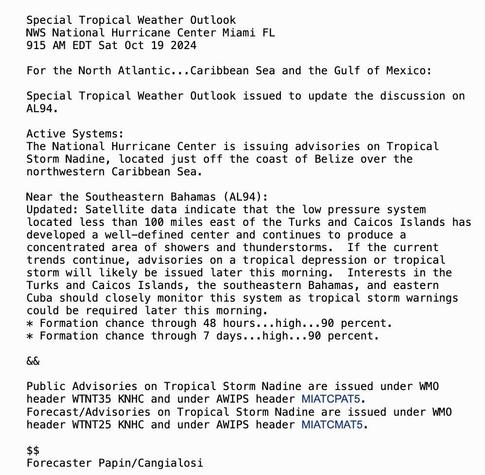
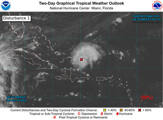
@NHC_Atlantic: 915am EDT Oct 19th -- A special Tropical Weather Outlook has been issued on #AL94, which now has a high chance to become a Tropical Depression or Storm (90% 🔴) as soon as later this morning. nhc.noaa.gov/gtwo.php?basin… https://twitter.com/NHC_Atlantic/status/1847634579181490281


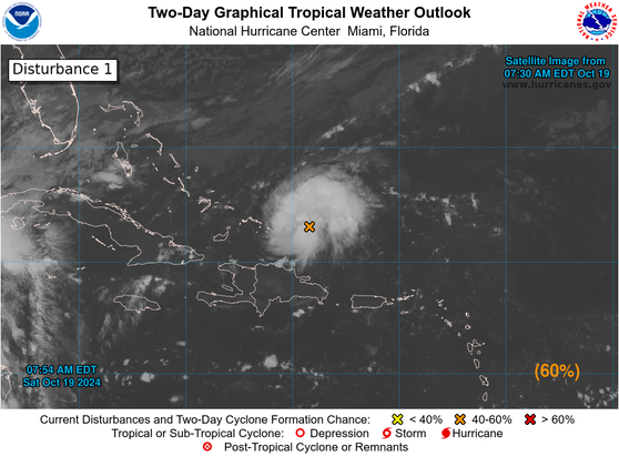
@NHC_Atlantic: 8am EDT 19th October: Showers & thunderstorms have become better organized with a small area of low pressure (#AL94) located N of the coast of the Dominican Republic. The system now has a medium chance (🟠60%) of genesis possibly as soon as later today. nhc.noaa.gov/gtwo.php?basin… https://twitter.com/NHC_Atlantic/status/1847618518369653112

National Hurricane Center (@NHC_Atlantic) on X
8am EDT 19th October: Showers & thunderstorms have become better organized with a small area of low pressure (#AL94) located N of the coast of the Dominican Republic. The system now has a medium chance (🟠60%) of genesis possibly as soon as later today. https://t.co/NERCKM0dOU
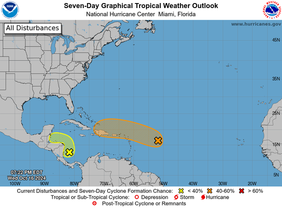
@NHC_Atlantic: 8 PM EDT Wed 10/16: NHC continues to monitor #AL94, with a medium chance of formation as it passes near the #VirginIslands & #PuertoRico Fri, then near the Greater Antilles over the weekend. A disturbance in the SW #Caribbean could bring locally heavy rain to parts of… https://twitter.com/NHC_Atlantic/status/1846697724621869164

National Hurricane Center (@NHC_Atlantic) on X
8 PM EDT Wed 10/16: NHC continues to monitor #AL94, with a medium chance of formation as it passes near the #VirginIslands & #PuertoRico Fri, then near the Greater Antilles over the weekend. A disturbance in the SW #Caribbean could bring locally heavy rain to parts of
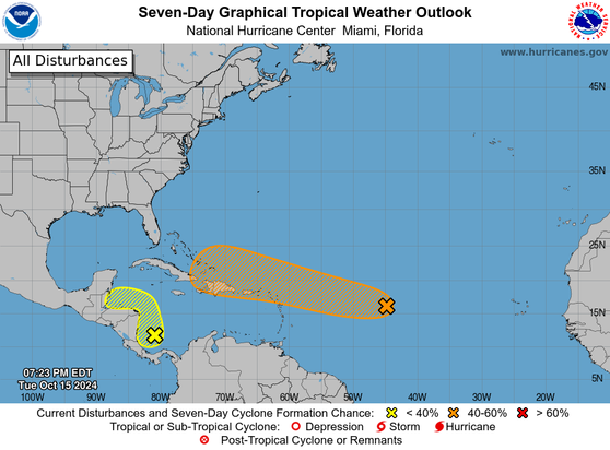
@NHC_Atlantic: 8 PM EDT Tue Oct 15: NHC is monitoring 2 areas for potential development. #AL94 has a medium chance of becoming a tropical depression as it passes near the NE Caribbean islands late this week. A disturbance in the SW #Caribbean has a low chance of formation but could bring heavy… https://twitter.com/NHC_Atlantic/status/1846339080927563823

National Hurricane Center (@NHC_Atlantic) on X
8 PM EDT Tue Oct 15: NHC is monitoring 2 areas for potential development. #AL94 has a medium chance of becoming a tropical depression as it passes near the NE Caribbean islands late this week. A disturbance in the SW #Caribbean has a low chance of formation but could bring heavy
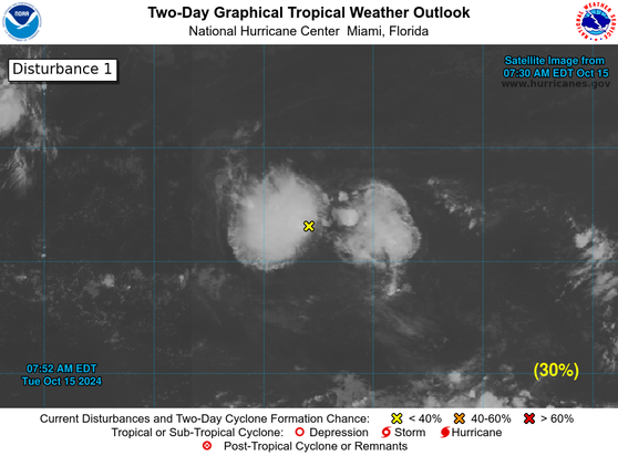
@NHC_Atlantic: 8 AM Tue Oct. 15: We continue to monitor an area of low pressure (#AL94) over the central tropical Atlantic, which is currently producing disorganized showers and thunderstorms. This system could become a tropical depression later this week while it approaches and moves near the… https://twitter.com/NHC_Atlantic/status/1846169851745677794

National Hurricane Center (@NHC_Atlantic) on X
8 AM Tue Oct. 15: We continue to monitor an area of low pressure (#AL94) over the central tropical Atlantic, which is currently producing disorganized showers and thunderstorms. This system could become a tropical depression later this week while it approaches and moves near the