XGRIDS (@XGRIDS_OFFICIAL)

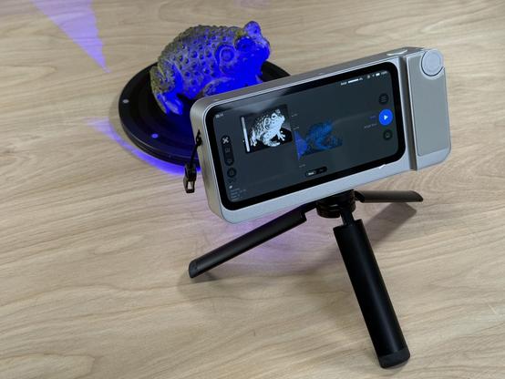
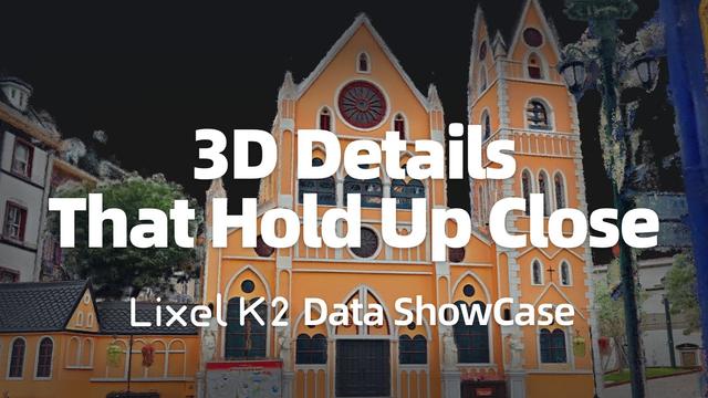
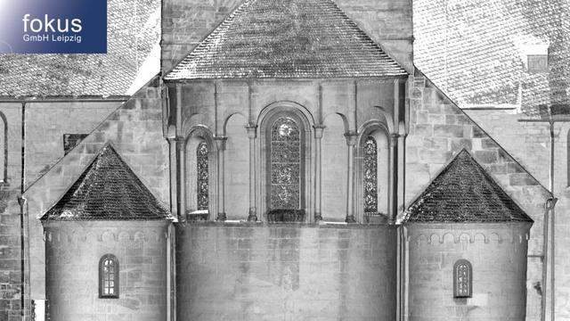
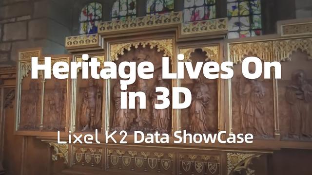
XGRIDS Lixel K2가 10분 만에 1cm 정확도의 포인트 클라우드, 3DGS, 메쉬 지오메트리를 캡처해 문화유산을 디지털 아카이브로 보존하는 사례를 소개했다. 현실 캡처·3D 스캐닝 워크플로우에 관심 있는 개발자에게 참고할 만한 하드웨어/소프트웨어 데모다.

https://x.com/XGRIDS_OFFICIAL/status/2055333108774236326

#3dscanning #pointcloud #digitaltwins #hardware

XGRIDS (@XGRIDS_OFFICIAL) on X

In 10 mins, XGRIDS Lixel K2 captured cultural heritage with 1 cm accurate point clouds, immersive 3DGS, and complete mesh geometry. From precise documentation to explorable digital archives, every detail is preserved for future generations. Lixel K2 👉🏻: https://t.co/5NUVBHUj04

X (formerly Twitter)

Just in time for the weekend, I'm glad to share my latest article with you, a follow to the recent #ProjectETERNAL announcement: "Documenting and Visualising Heritage with the Antigravity A1 + Gaussian Splatting"

🔗 https://nebulousflynn.substack.com/p/documenting-and-visualising-heritage

#3DScanning #CulturalHeritage #GLAM3D

The Portugal News: Portugal launches ‘Digital Noah’s Ark’ to preserve cultural heritage . “Work is underway on 3D surveying of 35 historical properties located throughout mainland Portugal, including monuments and archaeological sites classified as National Monuments or Properties of Public Interest.”

https://rbfirehose.com/2026/05/14/the-portugal-news-portugal-launches-digital-noahs-ark-to-preserve-cultural-heritage/
The Portugal News: Portugal launches ‘Digital Noah’s Ark’ to preserve cultural heritage

The Portugal News: Portugal launches ‘Digital Noah’s Ark’ to preserve cultural heritage . “Work is underway on 3D surveying of 35 historical properties located throughout mainland Portugal, i…

ResearchBuzz: Firehose

XGRIDS (@XGRIDS_OFFICIAL)

XGRIDS Lixel K2를 소개하며, 건물 외관을 엔지니어링급으로 포인트 클라우드, 메쉬, 3DGS 형태로 정밀 캡처할 수 있다고 강조한다. 더 촘촘한 데이터, 정확한 색상 매핑, 적은 노이즈, 완전한 기하 구조, 사실적인 색감과 포토리얼 텍스처가 특징이다.

https://x.com/XGRIDS_OFFICIAL/status/2052780449672355952

#xgrids #3dscanning #pointcloud #mesh #3dgs

XGRIDS (@XGRIDS_OFFICIAL) on X

Discover XGRIDS Lixel K2 — capture facades in Point Cloud, Mesh & 3DGS, all engineering-grade. - Point Cloud: Denser Data, Precise Color Mapping, Less Noise, - Mesh: Complete Geometry - 3DGS: Lifelike Color and Photo-real Texture. #XGRIDS #SpatialIntelligence

X (formerly Twitter)

XGRIDS (@XGRIDS_OFFICIAL)

NAB Show 2026의 촬영·방송 활용 사례로, PortalCam으로 촬영한 장면을 LCC Studio로 재구성해 복잡한 3DGS 씬을 몇 번의 클릭만으로 구조화되고 편집 가능한 데이터로 바꾸는 자동 세분화 기능을 소개했다.

https://x.com/XGRIDS_OFFICIAL/status/2050243733212295581

#3dgs #portalcam #lccstudio #broadcasting #3dscanning

XGRIDS (@XGRIDS_OFFICIAL) on X

NAB Show 2026 | Filming and Broadcasting Use Cases (7/10) Automatic Segmentation in 3DGS Scenes Using PortalCam for capture and LCC Studio for reconstruction, we demonstrate how complex scenes can be transformed into structured, editable 3DGS data in just a few clicks.

X (formerly Twitter)
@cmconseils Oh my gosh has anyone 3D scanned this? #3DScanning #3DPrinting

PetaPixel: Antigravity Is Preserving Historical Sites in 3D Using its 360° Drone. “Antigravity has announced Project Eternal, a global initiative unveiled following the International Day for Monuments and Sites, aimed at preserving cultural heritage through advanced imaging and Gaussian Splatting. The project brings together drone technology, panoramic capture systems, and 3D reconstruction […]

https://rbfirehose.com/2026/04/25/petapixel-antigravity-is-preserving-historical-sites-in-3d-using-its-360-drone/
PetaPixel: Antigravity Is Preserving Historical Sites in 3D Using its 360° Drone

PetaPixel: Antigravity Is Preserving Historical Sites in 3D Using its 360° Drone. “Antigravity has announced Project Eternal, a global initiative unveiled following the International Day for …

ResearchBuzz: Firehose
3D-Laserscanning-Auswertung für präzise Denkmaldokumentation #Restaurierung #ROMOE #3DScanning #Denkmalpflege #LasertechnikLaserscanning ermöglicht hochpräzise 3D-Vermessung von Objektoberflächen. Das 3D-Modul orientiert automatisiert mehrere Scans in einem einheitlichen Koordinatensystem, bereinigt die Daten und erstellt eine Gesamtpunktwolke – perfekt für Restaurierung & Denkmalpflege. Optional mit realer Objektfarbe. Entdecken Sie die Lösung von fokus GmbH Leipzig!
https://www.romoe.com/de/produkt/3d-modul-auswertung-laserscandaten_lljlngpx.html
3D-Laserscanning - Bauaufmaß - Romoe Netzwerk

Die fokus GmbH Leipzig erstellt formgetreue Bauaufmaße mit 3D-Laserscanning:

Romoe Netzwerk

Digital Survey Transformation Using Point Cloud to BIM

Traditional surveying approaches can result in incomplete measurements and repeated visits. Laser scanning captures millions of spatial data points. When integrated into Point Cloud to BIM, surveyors can create structured 3D models, improve communication, and enhance planning accuracy for construction projects.

Know more: https://www.hitechdigital.com/blog/point-cloud-to-bim-for-construction-surveyors

#PointCloudToBIM #ScanToBIM #BIM #ConstructionSurveying #LaserScanning #3DScanning