Vincent B. 🌱

@vincent@floss.social
12 Followers
137 Following
19 Posts
Worried about reducing the impact of our digital world
Freshly migrated from@masterbuck

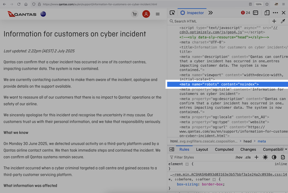
I am once again asking companies to not be absolute shitbags about their data breach disclosures, such as deliberately blocking search engines from seeing the page by using a "noindex" tag in its HTML.

Today's edition: Australian airline Qantas.

My story: https://techcrunch.com/2025/07/02/qantas-hack-results-in-theft-of-6-million-passengers-personal-data/

Dear Fedi friends, may I ask you a favor?

I would really appreciate it if you could boost this message. I have created a French version of my Fedi promo video - and a French landing page – that I hope can spread far and wide in the Francophone world:

https://news.elenarossini.com/fedivers-video/

Cette vidéo explique ce qu'est le fédivers en 4 minutes. N'hésitez pas à partager cette page avec vos amis et vos proches qui ne sont pas ici... J'espère que cette vidéo éveillera leur curiosité 💙🤍❤️

#TheFutureIsFederated

📺 Découvrez le fédivers : une nouvelle ère pour les réseaux sociaux

Découvrez un tout nouvel univers des réseaux sociaux, où la vie privée est respectée, les utilisateurs détiennent le pouvoir et les GAFAM n'ont pas leur mot à dire.

Elena Rossini
For the first time, I have managed to update all eleven of my country #train diagrams for the same year! And it's only May!😊 Represented are: 🇦🇹🇧🇪🇩🇰🇫🇮🇫🇷🇩🇪🇱🇺🇳🇱🇳🇴🇸🇪🇨🇭
I started making the diagrams because I missed the (useful) official ones and wanted a planning guide for my travels. I hope they help you too when travelling through central or northern 🇪🇺 #Europe (or whatever you need them for)!
👉 You find the 2025 train diagrams on my blog: https://larstransportmaps.com/
lars' transport maps

unofficial public transport maps

lars' transport maps
×
For the first time, I have managed to update all eleven of my country #train diagrams for the same year! And it's only May!😊 Represented are: 🇦🇹🇧🇪🇩🇰🇫🇮🇫🇷🇩🇪🇱🇺🇳🇱🇳🇴🇸🇪🇨🇭
I started making the diagrams because I missed the (useful) official ones and wanted a planning guide for my travels. I hope they help you too when travelling through central or northern 🇪🇺 #Europe (or whatever you need them for)!
👉 You find the 2025 train diagrams on my blog: https://larstransportmaps.com/
@larstransportworld May I put the link on my blog? https://stadtstreunen.at/ (in the footer)
Home - Stadtstreunen.at

Homepage von Stadtstreunen.at - Blog für Urbanität & Alltagspoesie. © Eva Maria Wohlfarter, 2016-2025

Stadtstreunen.at

@larstransportworld
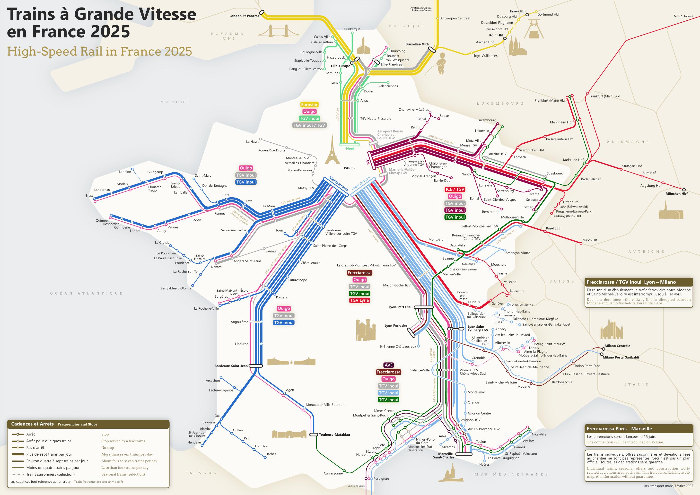
😠 Other places get cute landmarks but no cathedral in Strasbourg? 😜

Awesome work, thanks for sharing!

@larstransportworld Immer wieder tolle Karten, schön zum anschauen und benutzen :)

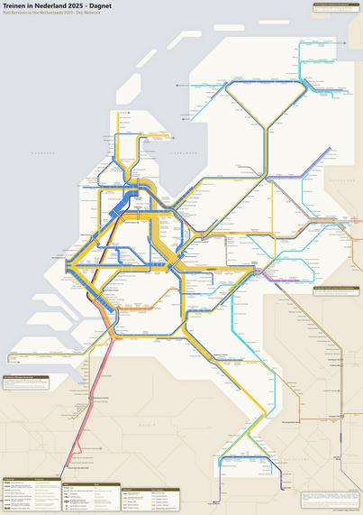
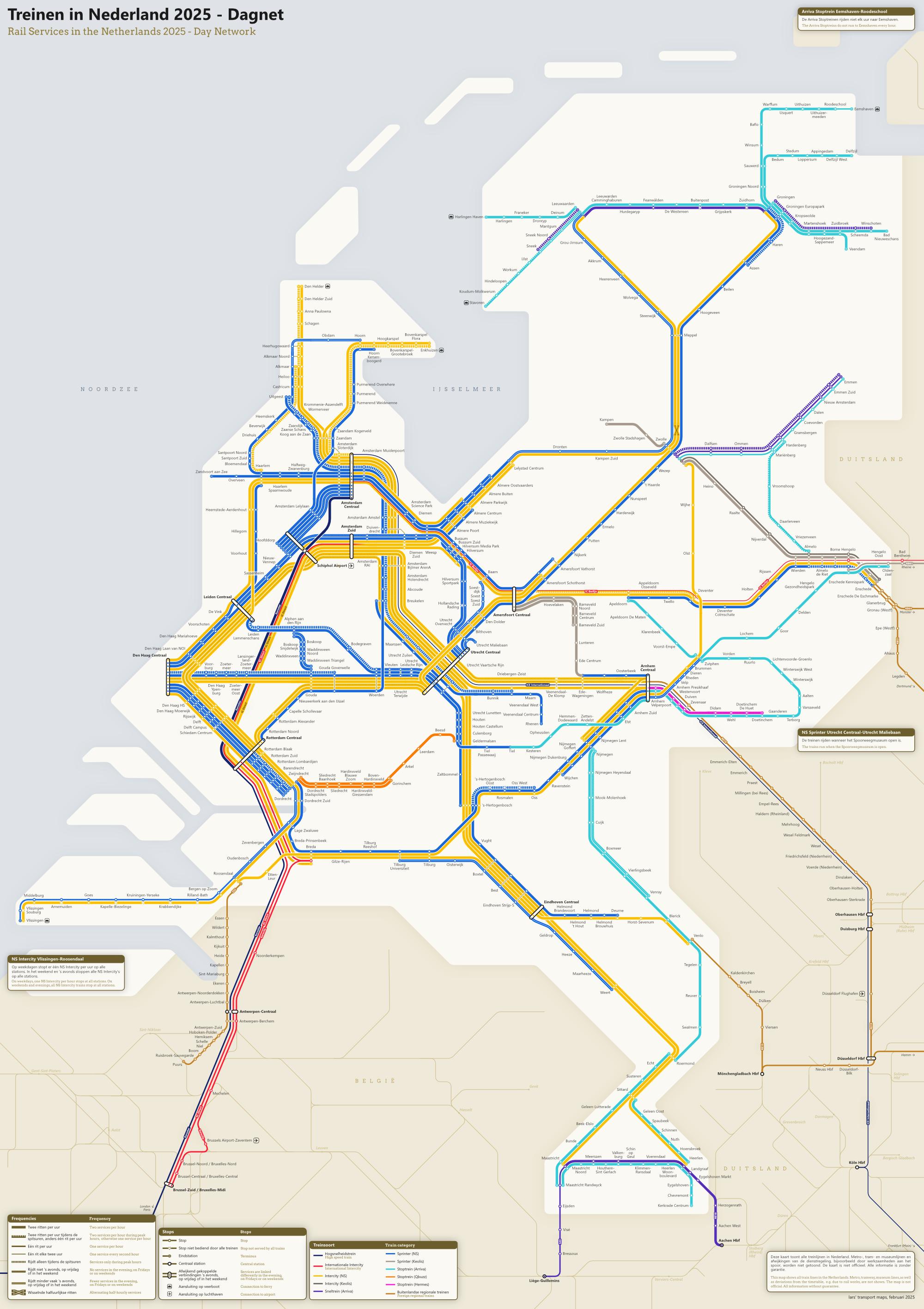
nur warum botherst du mit den Niederlanden? Finde die Spoorkaart von NS da schon sehr gut im Vergleich was andere Länder haben

@simonschre Ich habe (fast 😉) nichts gegen die Spoorkaart auszusetzen. Ich wollte nur auch eine eigene Version der Niederlande haben. Es fühlte sich irgendwie unvollständig an, alle Länder runderhum "kartiert" zu haben und die Niederlande nicht.
@larstransportworld lass mich raten, man sieht nicht was Intercity und was Sprinter ist?

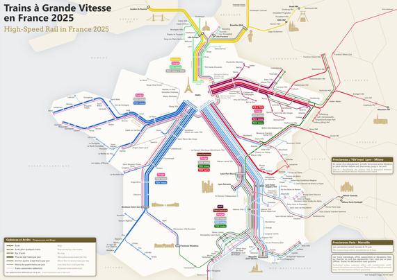
@larstransportworld so there is no train from Lyon to Bordeaux?

Really cool maps.

@NafiTheBear @larstransportworld

Serious railway tracks lie from Lyon to Bordeaux. There no more is a train schedule despite a recent revival attempt.

@NafiTheBear No, I don't know any direct connection Lyon-Bordeaux.

@NafiTheBear @larstransportworld This is like Toulouse. It is at the arse end. To go from Toulouse to Geneve, you have to go to Paris first. I think it is actually quicker to drive.

Same thing Toulouse to Marseille.

These maps illustrate the pain so well.

@ysb33r france should really do a ring Lille->Paris->Renne->Bordeaux->Toulouse->Marseille->Lyon->Strasbourg->Reim-> Lille

then it would be cool actually. Hehe
@larstransportworld

@larstransportworld

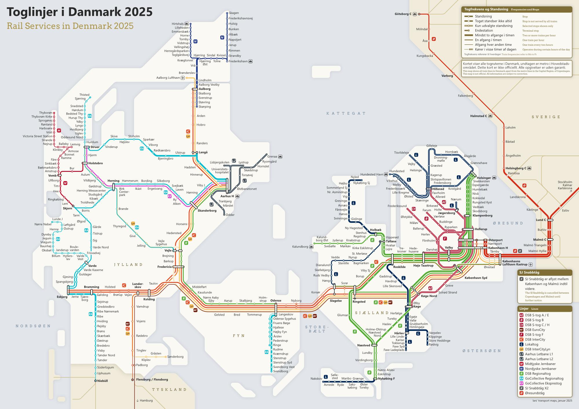
Väldigt fina kartor! Undrar varför de officiella börjar bli så sällsynta, de är mycket användbara när man vill planera lite, speciellt när man inte är helt inställd på ett speciellt resmål. Och att ha alla olika leverantörer på samma karta är guld värt.

@eq Ja, absolut! Tyvärr blir det till och med svårare att hitta samlade tidtabellerna på en sida för ett land! Jag saknar t.ex. fortfarande Resrobots tidtabellerna. 😐

@larstransportworld
I doubt I will ever get a chance to travel to Europe but still appreciate the effort.

People like you make this world a better place bit by bit, sharing nice things with the larger world not expecting anything in return.

@larstransportworld France looks like a dancer.
@larstransportworld Amazing #maps! Thanks for sharing!
@larstransportworld These are incredible, thank you, exactly what I need to plan my summer  

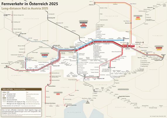
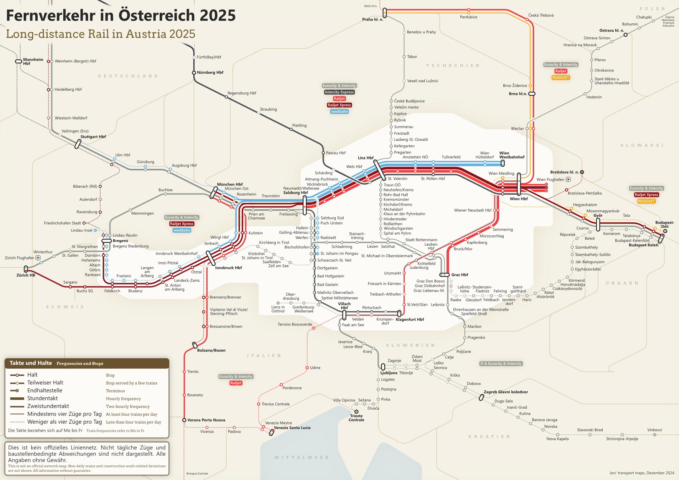
@larstransportworld  🚆 I have been looking at the Austrian map (I live here), we do have a trainline that is not included, maybe you can take a look? It's called Silva Nortica and runs along the "Franz Josefs Bahn" from Vienna to Prague, maybe this link helps: https://schedules.czech-transport.com/en/7?vid=R+326+Silva+Nortica

I like it as it connects my little hometown to two major European cities  So it might be a bit personal 

Plan Your Journey with Ease – Bus, Train, and Taxi Schedules

Find up-to-date schedules for buses, trains, and taxis in your area. Plan and book your travel efficiently.

@michaelpollak Thanks for the feedback, good point! I thought I should include this connection the first time it was introduced. However, it is only a Regionalexpress (right?), so it would be inconsistent to include it. I will have to change the map by 2026 anyway, with the introduction of the Koralmbahn and the new InterRegio trains, so I will also have to check the Prague connection again.
@larstransportworld Ah that s the distinction, makes sense. Great work!

@larstransportworld that's so cool!

Do you draw it with splines, or is there some graphics program where one locates the Knotenpunkte to get connected afterwards?

@Aubrieta I use an ordinary graphics programme (Affinity Designer). It is just a dumb assembly of vector shaped curves.
@larstransportworld woaah these are so coool ​
@larstransportworld
That is so cool!
Thank you for your work.
@larstransportworld poor people who want to go from Bordeaux to Lyon...
@larstransportworld Oh my gosh I didn't know you were on Mastodon! I'm a *huge* fan of your maps :D
@larstransportworld That is some amazing work but it may confuse high speed rails and high speed lines. Happy to help if wanted.
@paje_bzh I assume you are referring to the France diagram. Where exactly do you see a risk for confusion? The English title?
@larstransportworld my message was indeed unclear. I find the map confusing because I don't get what your trying to say. Is it about :
- where can you go, traveling a HS train ?
- where can you go, traveling at HS ?
- something else entierly ?
For example, if you want to visit Brest traveling from Paris, you can take a direct TGV (HS Train) but I may or may not use the LGV (HS line). Even if you do, you'll be travelling HS up until Rennes, then joining classic lines, travelling 220km/h.
@larstransportworld My confusion comme from the title, wich in French says "high speed trains", and in English "High speed rails".
But HS trains can use both classic and HS rails. And HS rails are rare and are the only tracks where HS trains can go full speed (300-320km/h). Trivia : It was demonstrated that HS trains can travel way faster, up to 574km.h But this kind of speed is not rentable nor safe ; very high mecanical tension in the catenaries, very straight track, heavily stabilised ballast
@paje_bzh Thank you for explaning. I think, I got your point. To summarise it, high-speed trains use both high-speed infrastructure and conventional infrastructure. My diagram shows the routes of the high-speed trains (on the whole route, of course, not just the section on the high-speed infrastructure). That is why the French name is "Trains à Grande Vitesse". (1/2)
@paje_bzh In English, I generally prefer the word "rail" to "trains", as it emphasises the system rather than a single train. This is why I have changed the title to "rail" on all maps in recent years. This is also why I wrote "High-Speed Rail in France" with the meaning of rail as "railway system" in mind (not with the meaning of rail as part of the infrastructure). (2/2)
@larstransportworld Which pride flag is northern France?

@larstransportworld This looks awesome! Thanks for the super nice map of Norway, I moved here a few years ago.

A super small remark: In the legend line 4 you write “far / til vestre” – translated to left? It should be “venstre” then (note the extra n).
But since it refers to the very top route maybe also “to the west” – “til/fra vesten” would work fine or mention that is is to Sweden/sverige

@larstransportworld And it might be mot (towards or German “nach”) not til (t0 or German “zu”), but those two I also often do not get right.

But besides that – absolutely awesome, thanks!

@kellertuer Thanks for your feedback. Of course, it was meant to be "venstre" instead of "vestre". I find it difficult to differentiate "till" and "mot" too (in Swedish). It is probably "mot" I guess...
@larstransportworld in prepositions like til/mot both Norwegian and Swedish are often identical. So probably it's mot.
And when you change it maybe using vest (west) is better than venstre (left).

@larstransportworld

as an american I am jealous of such a wonderful transport system.

@larstransportworld thank you! The sweden diagram was really helpful during my six months up there
@larstransportworld crazy how France is centralized compared to basically every other country...