Anton Biatov

@anton_btv
8 Followers
11 Following
9 Posts

Building LiDAR-based solar screening for Portugal 🇵🇹 and beyond
Replacing assumptions with data.
sun-potential-3d.com

My personal profile: https://www.linkedin.com/in/anton-biatov/

#solarenergy #geospatial #EUtech #BuildInPublic

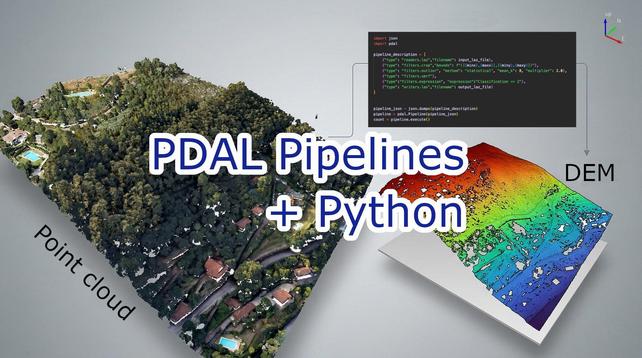
I recently published a practical guide to PDAL pipelines in Python for point cloud workflows.

It covers:

- PDAL pipeline structure
- running pipelines from Python
- returning results as NumPy arrays
- clipping and merging point clouds
- creating a GeoTIFF DEM from a LAZ file

The focus was on practical examples for real processing tasks.

https://medium.com/@anton.biatov/pdal-in-python-a-practical-guide-to-point-cloud-pipelines-1f7e2bc3e2ea

Also interested in what tools people use for point cloud work in production or research.

#PDAL #LiDAR #Python #GIS #geospatial

I wrote a detailed post on LinkedIn about the technical data analysis pipeline I use at my solar energy startup. And I took ChatGPT's advice about a provocative headline at the beginning of the post. Now I think that was a mistake. Because, judging by the statistics, my readers are mostly engineers, not marketers.

#SolarStartup #solarenergy #Geospatial #TechStartup #RemoteSensing #EarthObservation #DataScience #ClimateTech #BuildInPublic

Last 2 weeks building my solo B2B solar startup in Portugal:
- Built a list of 80 potential clients
- Sent 30+ cold emails
- Got 1 reply (pricing request)
- Posted 4 times on LinkedIn
- Started connecting in Linkedin
- Spent hours learning outreach
- Started building an interactive 3D map with demo data
Feeling pretty exhausted and noticing some self-sabotage creeping in.

If you’ve built a B2B startup solo — how did you get your first customers? What worked for you?

#buildinpublic #solopreneur

Open data is powerful.

But open data without practical tools remains abstract.

LiDAR point clouds, DSMs, irradiance models —
these are not just datasets.

They are ways to reduce blind decisions.

Less wasted materials.
Fewer unnecessary site visits.
More realistic expectations.

Perhaps the next step of the energy transition
is not just installing panels —
but improving how we decide where to install them.

#opendata #lidar #geospatial #3d #digitaltwin

I've worked in ecology and nature conservation for over 20 years.

And I've been thinking a lot about how much the energy transition still relies on assumptions.

Recently, high-quality open LiDAR datasets have become available across Europe.

Solar potential is often perceived as a promise.

But it's physics. Geometry. Shadows. Radiation intensity.

It can be measured.

So I started building a tool for modeling solar potential using opendata.

#renewableenergy #BuildInPublic #geospatial #EUtech

We’ve upgraded the Sun Potential 3D building solar report with new high-resolution maps for every analyzed property.

What’s new:
- LiDAR-based pseudo-orthophoto generated from point cloud data
- Digital Surface Model
- Annual POA heatmap for the building surroundings
- POA over Effective Roof Area map

Updated demo reports are available in English and Portuguese for all pricing plans on our website https://sun-potential-3d.com

#solarenergy #renewables #EUtech #BuildInPublic #geospatial

I’m building a small solar analysis project focused on Portugal 🇵🇹

Many rooftop PV estimates rely on simplified geometry. But open government LiDAR (25 cm resolution) allows precise modelling of roof shape and shading.

I combine:
• public LiDAR data
• digital surface models
• 8,760 hourly shading simulations
• PVGIS weather data

Goal: replace assumptions with measurable rooftop data.

#SolarEnergy #GIS #OpenData #RenewableEnergy #Portugal #BuildInPublic

Zonal Statistics in Python with Earth Engine and Colab (New guide)

Inside:
• Template for processing multiple rasters at once
• Unified reducer (mean/median/std/min/max in one pass)
• Convert to GeoDataFrame
• Export to GPKG/CSV + upload to Google Drive
• Visual maps (relief, NDVI, soil temperature)

🎁 Bonus: ready-to-use Colab notebook at the end.

Read more: https://medium.com/@anton.biatov/zonal-statistics-in-python-using-earth-engine-and-google-colab-7101d1d42ffd

---

#Geospatial #GIS #EarthEngine #Python #Geemap #ZonalStatistics #NDVI #DataScience

Zonal statistics in Google Earth Engine in a single pass: how to combine terrain and NDVI into a single stack, calculate mean/median/standard deviation/min/max for thousands of polygons, and immediately visualize and export the results. Assembling the package + ready-made script.

Watch the full tutorial here:
https://medium.com/@anton.biatov/how-to-combine-topography-and-vegetation-a-practical-guide-to-zonal-statistics-in-google-earth-d8167615937b

#GIS #EarthEngine #RemoteSensing #NDVI #DataScience #geospatial #EarthObservation #gischat