TOPIC> Clouds

"Dear dev-ops and admins, who are mostly overworked and close to burnout: DON'T PANIC!
These clouds have nothing to do with your work, but quite the opposite, they are supposed to lead you back to the original meaning of the word. So scroll calmly through this thread and let yourself fall into deep relaxation until your state of mind corresponds to a small pink fluffy cloud and breathe serenely in and out again .. in and out .. and now let the clouds in your mind just come and go .. come and go .. just wach these clouds passing by scrolling deeper down down down .."

2021 August 11

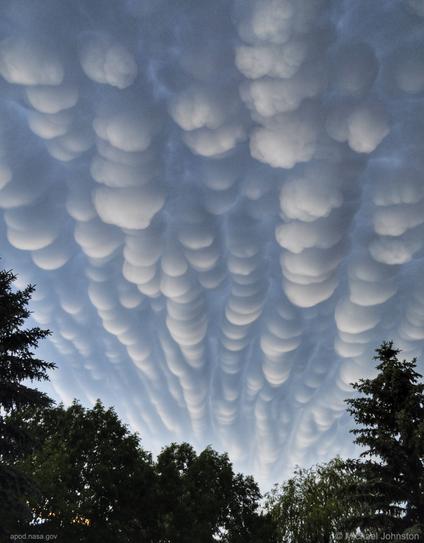
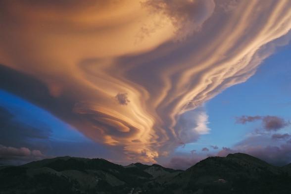
Mammatus Clouds over Saskatchewan
* Image Credit & Copyright: Michael F Johnston
https://www.instagram.com/beautyandruin/

Explanation:
When do cloud bottoms appear like bubbles? Normally, cloud bottoms are flat. This is because moist warm air that rises and cools will condense into water droplets at a specific temperature, which usually corresponds to a very specific height. As water droplets grow, an opaque cloud forms. Under some conditions, however, cloud pockets can develop that contain large droplets of water or ice that fall into clear air as they evaporate. Such pockets may occur in turbulent air near a thunderstorm. Resulting mammatus clouds can appear especially dramatic if sunlit from the side. The mammatus clouds pictured here, lasting only a few minutes, were photographed over Regina, Saskatchewan, Canada, just after a storm in 2012.

https://apod.nasa.gov/apod/ap210811.html

#space #earth #atmophere #clouds #weather #photography #science #physics #meteorology #nature

2022 January 16

A Retreating Thunderstorm at Sunset
* Image Credit & Copyright: Alan Dyer (The Amazing Sky)
https://amazingsky.net/about/
https://amazingsky.net/

Explanation:
What type of cloud is that? This retreating cumulonimbus cloud, more commonly called a thundercloud, is somewhat unusual as it contains the unusual bumpiness of a mammatus cloud on the near end, while simultaneously producing falling rain on the far end. Taken in mid-2013 in southern Alberta, Canada, the cloud is moving to the east, into the distance, as the sun sets in the west, behind the camera. In the featured image, graphic sunset colors cross the sky to give the already photogenic cloud striking orange and pink hues. A darkening blue sky covers the background. Further in the distance, a rising, waxing, gibbous moon is visible on the far right.

https://apod.nasa.gov/apod/ap220116.html

#space #earth #atmophere #clouds #weather #photography #science #physics #meteorology #nature

Mammatus Clouds
* UCAR Center for Science Education

Mammatus clouds are pouches of clouds that hang underneath the base of a cloud. They are most often associated with cumulonimbus clouds that produce very strong storms. These clouds usually form during warm months, and are formed by descending air in the cloud. Mammatus clouds are sometimes described as looking like a field of tennis balls or melons, or like female human breasts. In fact, the name "mammatus" comes from the Latin word mamma, or breast.

CREDIT
Gregory Thompson

https://scied.ucar.edu/image/mammatus-clouds

#space #earth #atmophere #clouds #weather #photography #science #physics #meteorology #nature #education

2018 August 19

Asperitas Clouds Over New Zealand
* Image Credit & Copyright: Witta Priester
https://www.flickr.com/people/wittap/

Explanation:
What kind of clouds are these? Although their cause is presently unknown, such unusual atmospheric structures, as menacing as they might seem, do not appear to be harbingers of meteorological doom. Formally recognized as a distinct cloud type only last year, Asperitas clouds can be stunning in appearance, unusual in occurrence, and are relatively unstudied. Whereas most low cloud decks are flat bottomed, asperitas clouds appear to have significant vertical structure underneath. Speculation therefore holds that asperitas clouds might be related to lenticular clouds that form near mountains, or mammatus clouds associated with thunderstorms, or perhaps a foehn wind -- a type of dry downward wind that flows off mountains. Such a wind called the Canterbury arch streams toward the east coast of New Zealand's South Island. The featured image, taken above Hanmer Springs in Canterbury, New Zealand, in 2005, shows great detail partly because sunlight illuminates the undulating clouds from the side.

https://apod.nasa.gov/apod/ap180819.html

#space #earth #atmophere #clouds #weather #photography #science #physics #meteorology #nature #education

2009 January 21

A Lenticular Cloud Over New Zealand
* Credit & Copyright: Chris Picking (Starry Night Skies Photography)
http://www.starrynightphotos.com/about_me.html

Explanation:
What's happening above those mountains? Several clouds are stacked up into one striking lenticular cloud. Normally, air moves much more horizontally than it does vertically. Sometimes, however, such as when wind comes off of a mountain or a hill, relatively strong vertical oscillations take place as the air stabilizes. The dry air at the top of an oscillation may be quite stratified in moisture content, and hence forms clouds at each layer where the air saturates with moisture. The result can be a lenticular cloud with a strongly layered appearance. The above picture was taken in 2002 looking southwest over the Tararua Range mountains from North Island, New Zealand.

https://apod.nasa.gov/apod/ap090121.html

#space #earth #atmophere #clouds #weather #photography #science #physics #meteorology #nature #education

From Wikipedia, the free encyclopedia

Asperitas (cloud)

Asperitas (formerly known as Undulatus asperatus) is a cloud formation first popularized and proposed as a type of cloud in 2009 by Gavin Pretor-Pinney of the Cloud Appreciation Society. Added to the International Cloud Atlas as a supplementary feature in March 2017, it is the first cloud formation added since cirrus intortus in 1951. The name translates approximately as "roughness".

The clouds are closely related to undulatus clouds. Although they appear dark and storm-like, they almost always dissipate without a storm forming. The ominous-looking clouds have been widespread in the Plains states of the United States, often during the morning or midday hours following convective thunderstorm activity.

According to International Cloud Atlas, Asperitas are defined as

Well-defined, wave-like structures in the underside of the cloud; more chaotic and with less horizontal organization than the variety undulatus. Asperitas is characterized by localized waves in the cloud base, either smooth or dappled with smaller features, sometimes descending into sharp points as if viewing a roughened sea surface from below.
Varying illumination levels and cloud thickness can lead to dramatic visual effects.
Occurs mostly with Stratocumulus and Altocumulus.
[...]
For more Information see ALT-Text and:
https://en.wikipedia.org/wiki/Asperitas_(cloud)

#space #earth #atmophere #clouds #weather #photography #science #physics #meteorology #nature #education

2016 February 14 (*)

A Heart Shaped Lenticular Cloud
* Image Credit & Copyright: Michael Kunze
https://www.sky-in-motion.de/de/
https://www.sky-in-motion.de/en/index.php

Explanation:
Can a cloud love a mountain? Perhaps not, but on a Valentine's Day like today (*), one might be prone to seeing heart-shaped symbols where they don't actually exist. A fleeting pareidolia, the featured heart was really a lenticular cloud that appeared one morning last July above Mount Cook National Park in New Zealand. A companion video shows the lenticular cloud was mostly stationary in the sky but shifted and vibrated with surrounding winds. The cloud's red color was caused by the Sun rising off the frame to the right. Lenticular clouds are somewhat rare but can form in air that passes over a mountain. Then, vertical eddies may form where rising air cools past the dew point causing water carried by the air to condense into droplets. Unfortunately, this amazing sight made the fascinated videographer late for breakfast.

https://apod.nasa.gov/apod/ap160214.html

#space #earth #atmophere #clouds #weather #photography #science #physics #meteorology #nature #education

"A green aurora through odd lenticular clouds!"

2021 May 30

Aurora over Clouds
* Image Credit & Copyright: Daniele Boffelli
https://www.facebook.com/danieleboffellifotografia/

Explanation:
Auroras usually occur high above the clouds. The auroral glow is created when fast-moving particles ejected from the Sun impact the Earth's magnetosphere, from which charged particles spiral along the Earth's magnetic field to strike atoms and molecules high in the Earth's atmosphere. An oxygen atom, for example, will glow in the green light commonly emitted by an aurora after being energized by such a collision. The lowest part of an aurora will typically occur about 100 kilometers up, while most clouds exist only below about 10 kilometers. The relative heights of clouds and auroras are shown clearly in the featured picture in 2015 from Dyrholaey, Iceland. There, a determined astrophotographer withstood high winds and initially overcast skies in an attempt to capture aurora over a picturesque lighthouse, only to take, by chance, the featured picture including elongated lenticular clouds, along the way.

https://apod.nasa.gov/apod/ap210530.html

#space #earth #atmophere #clouds #weather #photography #science #physics #meteorology #nature #education

Lenticular Clouds
-- UCAR Center for Science Education

Lenticular, or lee wave, clouds form downwind of an obstacle in the path of a strong air current. In the Boulder, Colorado area, the obstacle is the Front Range of the Rocky Mountains, seen at the bottom of the picture. Wind blows most types of clouds across the sky, but lenticular clouds seem to stay in one place. Air moves up and over a mountain, with the lenticular cloud forming just past the mountaintop. The cloud evaporates on the downwind side, so it appears stationary even though air is moving through the cloud. Lenticular clouds are lens-shaped and often look like flying saucers.

CREDIT
UCAR

https://scied.ucar.edu/image/lenticular-clouds

#space #earth #atmophere #clouds #weather #photography #science #physics #meteorology #nature #education

2016 March 2

Unusual Clouds over Hong Kong
* Image Credit & Copyright: Alfred Lee

Explanation:
What's that in the sky? Earlier this month, in the sky high above Hong Kong, China, not just one unusual type of cloud appeared -- but two. In the foreground was a long lenticular cloud, a cloud that forms near mountains from uprising air and might appear to some as an alien spaceship. Higher in the sky, and further in the background, was a colorful iridescent cloud. Iridescent clouds are composed of water droplets of similar size that diffract different colors of sunlight by different amounts. Furthest in the background is the Sun, blocked from direct view by the opaque lenticular, but providing the light for the colors of the iridescent. Either type of cloud is unusual to see in Hong Kong, and unfortunately, after only a few minutes, both were gone.

https://apod.nasa.gov/apod/ap160302.html

#space #earth #atmophere #clouds #weather #photography #science #physics #meteorology #nature #education

2005 August 21

A Lenticular Cloud Over Hawai'i
* Credit & Copyright: Peter Michaud (Gemini Obs.)
https://www.gemini.edu/

Explanation:
Can a cloud do that? Actually, pictured above are several clouds all stacked up into one striking lenticular cloud. Normally, air moves much more horizontally than it does vertically. Sometimes, however, such as when wind comes off of a mountain or a hill, relatively strong vertical oscillations take place as the air stabilizes. The dry air at the top of an oscillation may be quite stratified in moisture content, and hence forms clouds at each layer where the air saturates with moisture. The result can be a lenticular cloud with a strongly layered appearance. The above picture was taken near Mauna Kea, Hawaii, USA.

https://apod.nasa.gov/apod/ap050821.html

#space #earth #atmophere #clouds #weather #photography #science #physics #meteorology #nature #education

2003 March 26

A Lenticular Cloud Over Wyoming
* Credit & Copyright: Mark Meyer (Photo-Mark.com)

Explanation:
Is that a cloud or a flying saucer? Both, although it is surely not an alien spacecraft. Lenticular clouds can be shaped like a saucer, and can fly in the sense that, like most clouds, they are composed of small water droplets that float on air. Lenticular clouds are typically formed by high winds over rugged terrain and are particularly apparent when few other clouds are in the sky. Lenticular clouds can take on particularly strange, layered shapes. Above, a couple stopped their car near Yellowstone National Park in Wyoming, USA to photograph this lenticular cloud behind picturesque windmills.

https://apod.nasa.gov/apod/ap030326.html

#space #earth #atmophere #clouds #weather #photography #science #physics #meteorology #nature #education

Lenticular Cloud, Moon, Mars, Venus
* Image Credit & Copyright: Nuno Serrao

Explanation:
It is not every day that such an interesting cloud photobombs your image. The original plan was to photograph a rare angular conjunction of Mars and Venus that occurred a week and a half ago, with the added bonus of a crescent Moon and the International Space Station (ISS) both passing nearby. Unfortunately, on Madeira Island, Portugal, this event was clouded out. During the next day, however, a spectacular lenticular cloud appeared before sunset, so the industrious astrophotographer quickly formulated a new plan. A close look at the resulting image reveals the Moon visible toward the left of the frame, while underneath, near the bottom, are the famous planets with Venus being the brighter. It was the unexpected lenticular cloud, though, perhaps looking like some sort of futuristic spaceship, that stole the show. The setting Sun illuminated the stationary cloud (and everything else) from the bottom, setting up an intricate pattern of shadows, layers, and brightly illuminated regions, all seen evolving in a corresponding video. Mars and Venus will next appear this close on the sky in late August, but whether any place on Earth will catch them behind such a photogenic cloud is unknown.

https://apod.nasa.gov/apod/ap150302.html

#space #earth #atmophere #clouds #weather #photography #science #physics #meteorology #nature #education

From Wikipedia, the free encyclopedia

Lenticular clouds

Lenticular clouds
(from Latin lenticularis 'lentil-shaped', from lenticula 'lentil') are stationary clouds that form mostly in the troposphere, typically in parallel alignment to the wind direction. They are often comparable in appearance to a lens or saucer. Nacreous clouds that form in the lower stratosphere sometimes have lenticular shapes.

There are three main types of lenticular clouds:
+ altocumulus standing lenticular (ACSL),
+ stratocumulus standing lenticular (SCSL), and
+ cirrocumulus standing lenticular (CCSL),
varying in altitude above the ground.

[...] more in the reply

#space #earth #atmophere #clouds #weather #photography #science #physics #meteorology #nature #education

Lenticular clouds

From Wikipedia, the free encyclopedia

[...]
Formation and appearance

As air travels along the surface of the Earth, obstructions are often encountered, including natural features, such as mountains or hills, and artificial structures, such as buildings and other constructions, which disrupt the flow of air into "eddies", or areas of turbulence.

When moist, stable air flows over a larger eddy, such as those caused by mountains, a series of large-scale standing waves form on the leeward side of the mountain. If the temperature at the crest of the wave drops below the dew point, moisture in the air may condense to form lenticular clouds. Under certain conditions, long strings of lenticular clouds may form near the crest of each successive wave, creating a formation known as a "wave cloud". Those wave systems can produce large updrafts, occasionally enough for water vapour to condense and produce precipitation https://en.wikipedia.org/wiki/Precipitation

[...] more in the reply

#space #earth #atmophere #clouds #weather #photography #science #physics #meteorology #nature #education

Lenticular clouds

From Wikipedia, the free encyclopedia

[...]

Lenticular clouds have been said to be mistaken for UFOs, because many of them have the shape of a "flying saucer", with a characteristic "lens" or smooth, saucer-like shape. Lenticular clouds generally do not form over low-lying or flat terrain, so many people may have never seen one before and don't know that they can exist. Bright colours (called iridescence) are sometimes seen along the edge of lenticular clouds.

Pilots of powered aircraft tend to avoid flying near lenticular clouds because of the turbulence and sinking air of the rotor generated at the trailing edge of these clouds, but glider pilots actively seek them out in order to climb in the upward moving air at the leading edge. The precise location of the rising air mass is fairly easy to predict from the orientation of the clouds. "Wave lift" of this kind is often very smooth and strong, and enables gliders to soar to remarkable altitudes and to cover great distances. As of 2020, the gliding world records for both distance (over 3,000 km; 1,864 mi) and absolute altitude (over 22,000 metres; 74,334 ft) were set using such lift.

https://en.wikipedia.org/wiki/Lenticular_cloud

CREDIT
Contributors to Wikimedia projects

#space #earth #atmophere #clouds #weather #photography #science #physics #meteorology #nature #education

2019 August 19

Lenticular Clouds over Mount Etna
* Image Credit & Copyright: Dario Giannobile
https://www.dariogiannobile.com/blog

Explanation:
What's happening above that volcano? Although Mount Etna is seen erupting, the clouds are not related to the eruption. They are lenticular clouds formed when moist air is forced upwards near a mountain or volcano. The surreal scene was captured by chance late last month when the astrophotographer went to Mount Etna, a UNESCO World Heritage Site in Sicily, Italy, to photograph the conjunction between the Moon and the star Aldebaran. The Moon appears in a bright crescent phase, illuminating an edge of the lower lenticular cloud. Red hot lava flows on the right. Besides some breathtaking stills, a companion time-lapse video of the scene shows the lenticular clouds forming and wavering as stars trail far in the distance.

https://apod.nasa.gov/apod/ap190819.html

#space #earth #atmophere #clouds #weather #photography #science #physics #meteorology #nature #education

Scenery timelaps for the previous post

Lenticular Clouds over Mount Etna
* Image Credit & Copyright: Dario Giannobile
https://www.dariogiannobile.com/blog

https://apod.nasa.gov/apod/ap190819.html

#space #earth #atmophere #clouds #weather #photography #science #physics #meteorology #nature #education

2012 November 4

Lenticular Clouds Over Washington
* Credit & Copyright: Tim Thompson
https://www.dariogiannobile.com/blog

Explanation:
Are those UFOs near that mountain? No -- they are multilayered lenticular clouds. Moist air forced to flow upward around mountain tops can create lenticular clouds. Water droplets condense from moist air cooled below the dew point, and clouds are opaque groups of water droplets. Waves in the air that would normally be seen horizontally can then be seen vertically, by the different levels where clouds form. On some days the city of Seattle, Washington, USA, is treated to an unusual sky show when lenticular clouds form near Mt. Rainier, a large mountain that looms just under 100 kilometers southeast of the city. This image of a spectacular cluster of lenticular clouds was taken in 2008 December.

https://apod.nasa.gov/apod/ap121104.html

#space #earth #atmophere #clouds #weather #photography #science #physics #meteorology #nature #education

Lenticulars form and move differently than other clouds

Lenticular clouds are different from other clouds because they don’t form and move along but rather sit in one place, continually re-formed as air moves through them, causing them to morph slightly over time. They are the result of air rising to its condensation point over and downstream of an object, typically a mountain; however, they can also result from waves generated in the atmosphere itself.

Quote by Jesse Ferrell, AccuWeather meteorologist and senior weather editor

https://www.accuweather.com/en/weather-news/lenticular-clouds-sometimes-mistaken-for-ufos-are-in-a-league-of-their-own/1694242

#space #earth #atmophere #clouds #weather #photography #science #physics #meteorology #nature #education

2013 November 26

Cap Cloud over the Sierra Nevadas
* Image Credit & Copyright: GUIDO MONTAÑÉS
https://guidomontanes.wordpress.com/

Explanation:
One might say this was a bell weather day for the Sierra Nevada mountains. In January, just as the Sun was setting above the district of Albaicín in Grenada, Spain, a huge cloud appeared as a bell capping the Veleta peak. Such a Cap cloud is formed by air forced upwards by a mountain peak, with the air then cooling, saturating with moisture, and finally having its molecular water condense into cloud droplets. Such a bell-shaped cloud structure is unusual as air typically moves horizontally, making most clouds nearly flat across at the bottom. Vertical waves can also give additional lenticular cloud layers, as also seen above. Given the fleeting extent of the great cloud coupled with momentarily excellent sunset coloring, one might considered this also a bellwether day for an accomplished photographer.

https://apod.nasa.gov/apod/ap131126.html

#space #earth #atmophere #clouds #weather #photography #science #physics #meteorology #nature #education

2013 April 17

Mt. Hood and a Lenticular Cloud
* Image Credit & Copyright: Ben Canales
https://www.facebook.com/BCstartrail

Explanation:
What kind of cloud is next to that mountain? A lenticular. This type of cloud forms in air that passes over a mountain, rises up again, and cools past the dew point -- so what molecular water carried in the air condenses into droplets. The layered nature of some lenticular clouds may make them appear, to some, as large alien spaceships. In this case, the mountain pictured is Mt. Hood located in Oregon, USA. Lenticular clouds can only form when conditions are right -- for example this is first time this astrophotographer has seen a lenticular cloud at night near Mt. Hood. The above image was taken in mid-March about two hours before dawn.

https://apod.nasa.gov/apod/ap130417.html

#space #earth #atmophere #clouds #weather #photography #science #physics #meteorology #nature #education

Mammatus cloud

From Wikipedia, the free encyclopedia

Mammatus (also called mamma or mammatocumulus, meaning "mammary cloud") is a cellular pattern of pouches hanging underneath the base of a cloud, typically a cumulonimbus raincloud, although they may be attached to other classes of parent clouds. The name mammatus is derived from the Latin mamma (meaning "udder" or "breast").

According to the WMO International Cloud Atlas, mamma is a cloud supplementary feature rather than a genus, species or variety of cloud. The distinct "lumpy" undersides form as cold air sinks, creating pockets that contrast with the rising puffs of clouds caused by the convection of warm air. These formations were first described in 1894 by William Clement Ley.

Mammatus are most often associated with anvil clouds and also severe thunderstorms. They often extend from the base of a cumulonimbus cloud, but may also be found under altostratus, and cirrus clouds, as well as volcanic ash clouds. When occurring in cumulonimbus, mammatus are often indicative of a particularly strong storm. Due to the intensely sheared environment in which mammatus form, aviators are strongly cautioned to avoid cumulonimbus with mammatus as they indicate convectively induced turbulence. Contrails may also produce lobes but these are incorrectly termed as mammatus.

Mammatus may appear as smooth, ragged or lumpy lobes and may be opaque or translucent. Because mammatus occur as a grouping of lobes, the way they clump together can vary from an isolated cluster to a field of mammae that spread over hundreds of kilometers to being organized along a line, and may be composed of either unequal or similarly-sized lobes.
[...] read more in the next reply

CREDIT
Contributors to Wikimedia projects
* Image - Dr Ashok Kolluru

#space #earth #atmophere #clouds #weather #photography #science #physics #meteorology #nature #education

Mammatus cloud

From Wikipedia, the free encyclopedia

[...]
The individual mammatus lobe average diameters of 1–3 kilometres (0.6–1.9 mi) and lengths on average of 1⁄2 kilometre (0.3 mi). A lobe can last an average of 10 minutes, but a whole cluster of mamma can range from 15 minutes to a few hours. They are usually composed of ice, but also can be a mixture of ice and liquid water or be composed of almost entirely liquid water.

True to their ominous appearance, mammatus clouds are often harbingers of a coming storm or other extreme weather system. Typically composed primarily of ice, they can extend for hundreds of miles in each direction and individual formations can remain visibly static for ten to fifteen minutes at a time. They usually appear around, before, or even after severe weather.

Hypothesized formation mechanisms

The existence of many different types of mammatus clouds, each with distinct properties and occurring in distinct environments, has given rise to multiple hypotheses on their formation, which are also relevant to other cloud forms.

One environmental trend is shared by all of the formation mechanisms hypothesized for mammatus clouds: sharp gradients in temperature, moisture and momentum (wind shear) across the anvil cloud/sub-cloud air boundary, which strongly influence interactions therein.
[...] Please read further next reply.

#space #earth #atmophere #clouds #weather #photography #science #physics #meteorology #nature #education

[...]
The following are the proposed mechanisms, each described with its shortcomings:

+ The anvil of a cumulonimbus cloud gradually subsides as it spreads out from its source cloud. As air descends, it warms. However, the cloudy air will warm more slowly (at the moist adiabatic lapse rate) than the sub-cloud, dry air (at the dry adiabatic lapse rate). Because of the differential warming, the cloud/sub-cloud layer destabilizes and convective overturning can occur, creating a lumpy cloud-base. The problems with this theory are that there are observations of mammatus lobes that do not support the presence of strong subsidence in the lobes, and that it is difficult to separate the processes of hydrometeor fallout and cloud-base subsidence, thus rendering it unclear as to whether either process is occurring.
+ Cooling due to hydrometeor fallout is a second proposed formation mechanism. As hydrometeors fall into the dry sub-cloud air, the air containing the precipitation cools due to evaporation or sublimation. Being now cooler than the environmental air and unstable, they descend until in static equilibrium, at which point a restoring force curves the edges of the fallout back up, creating the lobed appearance. One problem with this theory is that observations show that cloud-base evaporation does not always produce mammatus. This mechanism could be responsible for the earliest stage of development, but other processes (namely process 1, above) may come into play as the lobes are formed and mature.
+ There may also be destabilization at cloud base due to melting. If the cloud base exists near the freezing line, then the cooling in the immediate air caused by melting can lead to convective overturning, just as in the processes above. However, this strict temperature environment is not always present.
[...] Please read next reply

#space #earth #atmophere #clouds #weather #photography #science #physics #meteorology #nature #education

[...]
+ The above processes specifically relied on the destabilization of the sub-cloud layer due to adiabatic or latent heating effects. Discounting the thermodynamical effects of hydrometeor fallout, another mechanism proposes that dynamics of the fallout alone are enough to create the lobes. Inhomogeneities in the masses of the hydrometeors along the cloud-base may cause inhomogeneous descent along the base. Frictional drag and associated eddy-like structures create the lobed appearance of the fallout. The main shortcoming of this theory is that vertical velocities in the lobes have been observed to be greater than the fall speeds of the hydrometeors within them; thus, there should be a dynamical downward forcing, as well.
+ Another method, that was first proposed by Kerry Emanuel, is called cloud-base detrainment instability (CDI), which acts very much like convective cloud-top entrainment. In CDI, cloudy air is mixed into the dry sub-cloud air rather than precipitating into it. The cloudy layer destabilizes due to evaporative cooling and mammatus are formed.
+ Clouds undergo thermal reorganization due to radiative effects as they evolve. There are a couple of ideas as to how radiation can cause mammatus to form. One is that, because clouds radiatively cool (Stefan–Boltzmann law) very efficiently at their tops, entire pockets of cool, negatively buoyant cloud can penetrate downward through the entire layer and emerge as mammatus at cloud-base. Another idea is that as the cloud-base warms due to radiative heating from land surface's longwave emission, the base destabilizes and overturns. This method is valid for only optically thick clouds. However, the nature of anvil clouds is that they are largely made up of ice, and are therefore relatively optically thin.

From Wikipedia, the free encyclopedia
CREDITS
Contributors to Wikimedia projects

#space #earth #atmophere #clouds #weather #photography #science #physics #meteorology #nature #education

Gravity waves

are proposed to be the formation mechanism of linearly organized mammatus clouds. Indeed, wave patterns have been observed in the mammatus environment, but this is mostly due to gravity wave creation as a response to a convective updraft impinging upon the tropopause and spreading out in wave form over the entirety of the anvil. Therefore, this method does not explain the prevalence of mammatus clouds in one part of the anvil versus another. Furthermore, time and size scales for gravity waves and mammatus do not match up entirely. Gravity wave trains may be responsible for organizing the mammatus rather than forming them.

From Wikipedia, the free encyclopedia
CREDITS
Contributors to Wikimedia projects

#space #earth #atmophere #clouds #weather #photography #science #physics #meteorology #nature #education

CSICOP's Young Skeptics Program

CSICOP's Young Skeptics Program

@grobi Do they take passengers? I'm looking for a ride...

@Satiah

.. sure, you only need that towel!

https://en.wikipedia.org/wiki/Towel_Day

"A towel, it says, is about the most massively useful thing an interstellar hitchhiker can have. Partly it has great practical value. You can wrap it around you for warmth as you bound across the cold moons of Jaglan Beta; you can lie on it on the brilliant marble-sanded beaches of Santraginus V, inhaling the heady sea vapours; you can sleep under it beneath the stars which shine so redly on the desert world of Kakrafoon; use it to sail a miniraft down the slow heavy River Moth; wet it for use in hand-to-hand-combat; wrap it round your head to ward off noxious fumes or avoid the gaze of the Ravenous Bugblatter Beast of Traal (such a mind-bogglingly stupid animal, it assumes that if you can't see it, it can't see you — daft as a brush, but very very ravenous); you can wave your towel in emergencies as a distress signal, and of course dry yourself off with it if it still seems to be clean enough. "

— Douglas Adams, The Hitchhiker's Guide to the Galaxy

Towel Day - Wikipedia

@grobi I have just the right towel for all possible applications. 👍