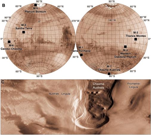
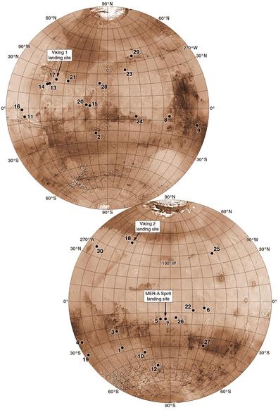
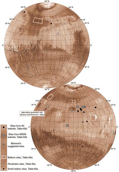
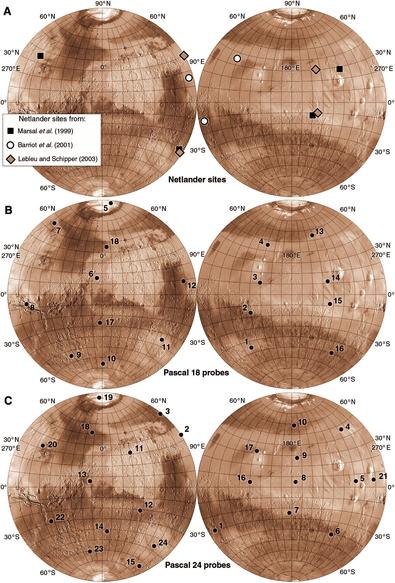
Those landers are supposed to lie on big circles, but they might not look like it because of the map projection. I like the 2 hemisphere look so I use it a lot but I admit it is not the best for these network maps. But other projections have problems too so we are staying with this one.

We've seen quite a few network ideas so you may be pleased to learn that we are going to look at some very different things now. I see you shiver with antici.......pation (I see all).

The first item in this set of Mars maps was the vast human exploration project of Wernher von Braun. Here is another, from Douglas Nash of JPL in 1989. Nash looked at human exploration of the Moon, Mars, Phobos and asteroids. He assumed Mars would come after new orbiters, sample return and a network mission. 7 sites were identified based on Viking-era images and geology, shown in this map. One of the sites is illustrated here, Chasma Australe on the south polar ice cap.
#maps #mars

This is a 1993 proposal from French space agency CNES, described by François Costard in 1993. A long range rover would land in Kasei Valles, one of the giant channels on Mars, and drive over 300 km northwards. It would drop off three instrument packages (fixed stations) and investigate several different geological features and rock types.

We have seen rovers before but tomorrow we will see something brand new.

#maps #mars #marsrover

Here are two Mars aircraft missions proposed in the 1990s for the Discovery program of small, less expensive missions. At left is the 1998 MAGE (Mars Aircraft for Geophysical Exploration) mission route (I only include missions with a route in the proposal - there were others). It zigzags over the Valles Marineris in a c. 3 hour, 1750 km mission with cameras and geophysical instruments, flying on the 100th anniversary of the Wright Brothers flight... so it was called Kitty Hawk.
#maps #mars
The second map shows the path of the AME (Airplane for Mars Exploration) mission proposed by NASA Ames in 1996. Its path is 3400 km long, flown over 2 days separated by long enough to transmit all the day 1 data, possibly up to 40 days. The first flight would start near Apollinaris Mons, fly around Gusev and land in it. The second would explore the highlands and a big valley. Alas, the only flight on Mars so far has been the plucky little helicopter Ingenuity.
#mars
This map shows sites considered for Mars 94, a Russian mission which didn't happen. We know very little about site selection for their earlier missions, but this was included in the Mars Landing Site Catalog and also discussed at a Mars Pathfinder landing site workshop in 1994. The mission history is complicated... it began as 'Columbus' or Mars 92, to fly in 1992 with orbiters, balloons, landers and rovers. When delayed to 1994 the Columbus name was dropped.
#maps #mars #mars94
Columbus was delayed to 1994 so the chance to commemorate the 1492 voyage was lost and the mission became Mars 94. It was downsized drastically - 1 orbiter, 2 small landers, 2 penetrators. Rovers would fly on a 1996 mission (Mars 96) which was soon delayed to 1998 - guess what it was called. Yes, Mars 98. Mars 94 was pushed into 1996 so it became Mars 96 - a trifle confusing. Be careful with the literature! Needless to say none of this happened.
#mars #mars94

Jack Farmer of NASA Ames chose sites from the Landing Site Catalog with exobiology potential - where remains of past life might be preserved. Mostly this meant sites with evidence of water such as channels or lake beds. The Viking sites were added for comparison but ranked low for exobiology potential. These were studied in 1995 to help plan future missions but not directed at a specific mission proposal.

After this we will see some more Russian plans.
#maps #mars #exobiology

Things were tough for Russian space in the 1990s, and several ideas emerged to work with them, including using ICBMs as launch vehicles - such as this:

https://marspapers.org/paper/Lusignan_2000_2.pdf

This report mentions a Marsokhod evolved from the Lunokhods. Another Marsokhod mission was described by the lead author (Bruce Lusignan of Stanford) in 1996. The rover might collect samples for later return to Earth. An orbiter would relay data and might drop penetrators...

#mars #marsokhod

... but where would Marsokhod go? (that is always my chief preoccupation). Nine sites were described, and are shown on this map. One was illustrated in more detail, on the plateau of Aurorae Planum south of Capri Chasma (and very close to some candidate Viking sites). It is site G on the global map. Site E is quite close to Viking 1, site D is near Viking 2. I wouldn't fancy driving a rover near Viking 2. Tomorrow, more Russia.

#maps #mars #marsokhod

We will look at recent lunar missions after this trip to Mars. This sequence is supposed to be about missions which didn't happen. This one did happen but only just... Mars 96 launched on 17 November 1996 but failed to leave Earth orbit and fell into the ocean near Chile a day later. Here I focus on landing site considerations, which are perhaps not well known. The mission had an orbiter, 2 landers and 2 penetrators, but versions with balloons were talked about early in planning.
#mars #mars96
This map collects various sites for different versions of the mission. Two are for balloons and date from the early 90s (the Blamont sites were balloons). Others are for the landers and penetrators but there were several versions of them. The sites labelled IKI (Institute for Cosmic Research, in Moscow) is the final plan for the mission. Tables of site data are in my book, which is the source for these maps.
#maps #mars #mars96

Our next mission which didn't happen is the Mars Reference Mission, a study done during the late 1990s of a human Mars mission. Infrastructure and supplies would be launched in 2007, 2009 and 2011, and a six person crew would fly in 2013. Sample return and resource utilization experiments would be done first. A return vehicle and fuel manufacturing hardware would go next and people would not leave Earth until everything was ready for them.

#mars #humanstomars

The focus was on Valles Marineris and Tharsis, and several university groups developed exploration plans. The top map shows a landing area in the canyon system where layered sediments suggested deposition in a lake. Another scenario involved a base camp (with several candidates around Tharsis) and long rover traverses to points of scientific interest during a 500 day stay before returning to Earth.

#mars #humanstomars

Stratigraphy - the study of strata or layers of rock, is an important tool for studying any planet's history. A 1999 JPL study for a Mars Stratigraphy Mission was directed at a large, well-exposed stratigraphic section in the walls of Valles Marineris, at the time the best imaged section of its kind on Mars. The maps show the site with an ellipse just touching the rim of the canyon. A rover would drive to the rim and anchor a tether at the top...
#maps #mars #stratigraphy
..., then the rover would descend on the tether, examining layers of rock on the way down. These were thought to be Tharsis lava flows. Planners lacked the modern compositional datasets which took us to places like Gale and Jezero, so past landing site suggestions can seem rather uninspiring today. But the views would have been sublime.
#mars #stratigraphy
Here are two mission concepts from 1998 and 1999 combined into one map. George James (University of Houston) et al. (1998) identified 3 potential ISRU (in situ resource utilization) sites marked as circles on the map. Antoine Mocquet (1999) (University of Nantes) mapped a geophysical network layout with a large triangle and antipodal point (white dots) and 3 less sensitive stations around each node to make 4 local networks.
#maps #mars #marsnetwork #isru
Life on Mars has always been a draw, so where should we look? 25 years ago a popular idea was hydrothermal sites. As the name suggests, they combine heat and water, so obvious candidates would be volcanic areas with evidence of water. James Dohm (then at U. Arizona) mapped two sets of them, shown on this map. 1998 sites were in Thaumasia where many channels indicate water. Sites in 2000 were more widely distributed around Tharsis. None of these have been visited yet.
#maps #mars #hydrothermal
We skipped Mars Pathfinder and Mars Polar Lander because they actually happened (though MPL crashed), so the next mission which did not happen was Mars Surveyor 2001. Its goal was to explore a site with a record of past water or even life, using a large rover. Soon it was downsized and would have carried a little rover called Marie Curie, similar to Sojourner. One workshop in 1998 looked at sites for the big rover, and another in 1999 looked at sites for Marie Curie.
#mars #mars2001 #mariecurie
This map shows the many sites considered at the 2 workshops. The top 2 maps are for the big rover, the bottom 2 maps for the little one. That's a lot of sites! Site selection was now making use of high resolution images and topography from Mars Global Surveyor (both much better than Viking data) and even the Termoscan infrared instrument on Phobos 2. We will see some possible rover traverses tomorrow.
#maps #mars #mars2001
A few of the many sites for Mars Surveyor 2001 were given suggested traverses for the mission's big rover (before it was downsized). Traverses are typically about 40 km long, about the scale we are seeing today for our big rovers. They are shown here with some geological annotation. The Thira crater lake site (41 on yesterday's map) might not sound familiar, but Thira is a small crater inside Gusev, its rim visible to the Spirit rover from the top of Husband Hill.
#maps #mars #mars2001
That site in Gusev was not the only current site in that old list. Gale crater was another, though no traverse was illustrated. There was no compositional data to identify the hematite on Vera Rubin Ridge, or the clay in Glen Torridon, so a traverse like Curiosity's would not be likely. Jezero was not on the list, and Mars Global Surveyor MOC images had not yet revealed its delta, but they would soon. Here are a few more sites to ponder.
#maps #mars #mars2001
The maps of all 2001 sites posted 2 days ago covered 2 workshops, the top for the first version of Mars Surveyor 2001 with a big rover, the bottom for the version with a small rover. A small rover implied a short traverse, 1000 m maximum, so sites which could be studied in a compact area were chosen for the second set. A subset of those sites were chosen by Jack Farmer (Arizona State University) et al. for astrobiology. The top map shows Farmer's sites.
#maps #mars #mars2001
Below the map of Farmer's sites are examples of sites drawn from the larger set mapped 2 days ago for the downsized mission. I won't show all of them. Of particular note here are sites in Meridiani near Opportunity's later landing site. Because the traverse would be so short these sites don't come with routes. Only one site was shown with a rover route (we'll see it tomorrow). For scale, 1 degree of latitude is c. 60 km, a handy thing to remember.
#mars #mars2001
A few more of the Mars Surveyor 2001 sites. Ellipses, circles, points - the different styles are just copied from the sources, abstracts for the workshop. Only site 58 (800 km east of Gale crater) had a traverse map. It's only a possible example because it would depend on the exact landing site, which could not be predicted. That's like Spirit and Opportunity, traverse planning only started when the team knew where they landed. Next: the shortlist.
#maps #mars #mars2001

All that work brought the Mars Surveyor 2001 mission to the point of drawing up a shortlist of preferred sites. But Mars Polar Lander crashed in 1999 and our plucky lander was cancelled. A few years later it was taken out of storage and used successfully for Phoenix. InSight was also the same design.

The shortlist of 8 sites had 2 in Meridiani and 4 in Isidis. The hematite site is close to Opportunity's location.
#maps #mars #mars2001

Wait - hematite? Haven't I been saying that composition was not available? It was just coming now, at low resolution, from Mars Global Surveyor's Thermal Emission Spectrometer. The background images in this map are from Mars Odyssey's THEMIS infrared instrument. Dark areas are warmed more by the Sun and are bright in THEMIS daytime images, but I have inverted the shading so dark areas look dark.

Tomorrow - Wobble! What if anything am I talking about?

#mars #mars2001

Wobble! Or rather WOBBLE (Water Observations from a Balloon Borne Light Explorer - you have to love a fun acronym). Mars Global Surveyor's MOC images showed us gullies on crater walls and some may have been active (though with what was not so obvious). But there was a hope that they might be cut by water seeping from an aquifer transected by the crater wall, so a good place to seek water. Bogdan Udrea (U. Washington in Seattle) et al. suggested this mission in 2002...

Here is the Wobble paper:

https://ntrs.nasa.gov/api/citations/20030020925/downloads/20030020925.pdf

The target was Sarh crater in the southern highlands. Gullies on its upper wall were the science target. A Pathfinder-like lander would release a 24 m diameter hydrogen balloon which would drift over the gullies with cameras, ground-penetrating radar and other instruments to try to detect water. It would be released when the wind was blowing in the right direction and could make several hops.
#maps #mars #wobble

Sarh was nicknamed Aerobraking Crater, not because the WOBBLE mission would use aerobraking but because Mars Global Surveyor did. This crater was seen in an early MOC image taken during the aerobraking phase of the mission.

The MOC image in map C shows dark markings inside Sarh. The infrared image in B makes them look bright. That's why I sometimes reverse shading in IR images. Why not here? it would invert shadows too, making light appear to come from the south - it can't at this latitude.

The next mission that didn't happen - the first from vol. 2 of my Mars trilogy (vol. 3 was just released) - is from the Vision for Space Exploration, President GW Bush's 2004 proposal. This concept was presented by Lockheed Martin in 2004 and shares something with the current lunar proposal called Endurance-A. Robotic rovers drive from 3 destinations to a human landing site in Chryse, gathering samples for the crew to return to Earth.
#maps #mars #visionforspaceexploration
The northern site is SE of the later Phoenix site. The northern and southern sites would be looking for water in places where orbital neutron data suggested hydrogen was present (implying water). This plan assumes rovers could travel vast distances, far exceeding the few tens of km our current rovers can drive. Also they would have to move a lot faster than our current rovers to accomplish the mission in a reasonable time. In 2004 this was impossible.
#mars #marsrovers

A 2005 presentation by Jack Jones of JPL at a planetary probe workshop described a Mars balloon mission using a Montgolfiere hot air balloon. The heat is from sunlight warming the balloon. It would enter the atmosphere, descend on a parachute and be dropped from that to inflate as it fell. It might have a lifetime of a month and could make several touchdowns to deploy instruments as it circled the sunlit summer pole.

#maps #mars #marsballoon

Here is the presentation:

https://www.cds.caltech.edu/~marsden/wiki/uploads/jplcdsmeetings/deploy/Jones_MontgolfiereBalloons_Inte.pdf

It was also considered for Titan.

Comparing my map with the one in the presentation, you will see that mine is considerably simplified from the original.

Next we will see a few more network designs before returning to airborne missions.

Hard to believe we have had so many plans for network missions, and no actual mission. Here are 3 more plans. At top is Netlander, a French (CNES) design which appeared in several variations. 3 or 4 landers would do geophysics and meteorology. Pascal was a proposal for NASA's Mars Scout program (and we will see others). It would have 18 or 24 small landers, globally distributed, to study meteorology for up to 10 Mars years.
Tomorrow we will slip the surly bonds of Mars.
#maps #mars #marsnetwork
Mars Scout was a program like Discovery, intended to fly competed small missions fairly frequently. Mars was excluded from Discovery while Mars Scout was in operation. Two missions flew - Phoenix and MAVEN. Now Mars Scout is over and Mars is back in Discovery. But while it lasted there were lots of proposals. I will only look at those for which I have landing site details. The first is a Mars aircraft called ARES (Aerial Regional-scale Environmental Survey).
#mars #marsscout

@PhilStooke
Maybe #KSR had seen such maps; he had made friends with young scientists studying in Boulder, CO, and calls one of them, Chris McKay, who later went on to work for #NASA, "my Mars guy". That's where he got those areoforming ideas conceived.

The map shows some places in the general area around Ophir Chasma, like the Transverse Highway which becomes the North Ophir Road as it reaches higher ground outside of the chasma.

Maybe mixing reality with #fiction is good for geology? 🙃 😀

@65dBnoise I think mixing reality with fiction is good for both of them.

@PhilStooke
In a parallel #SciFi universe, that first map is ~100km away from Libya Station, where residents of Borroughs escaped on foot after the dike built around it was breached by the Reds and the city flooded and submerged.

More about Borroughs:
https://www.kimstanleyrobinson.info/content/burroughs

#KSR #KimStanleyRobinson #Mars #Solarocks #Space

@65dBnoise Very cool. I have a longstanding interest in cartography for fiction, including the KSR and ERB versions of Mars.