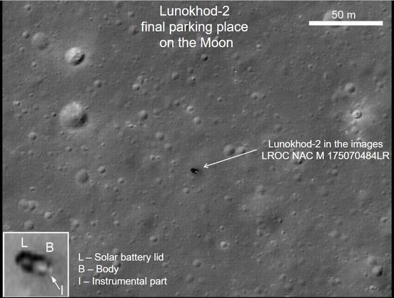
Where did I barge into this story? We have to go back to March 2010. LRO has begun releasing images of landed spacecraft on the Moon. Remember the map I showed earlier, an old map of the Lunokhod 2 route with LRO images showing that the rover ended further north than previously thought. Now - these LRO Narrow Angle Camera images are big - 5000 by 50,000 pixels, and at the time my software was limited to 30,000 pixels so I always cropped images.
#moon #luna21 #lunokhod2
So this particular image got cropped, but rather catastrophically I cropped off the actual rover. Luckily nobody noticed... until I spotted that dark marking and thought it might be the rover. I made this image. You can see the tracks, but in this view you can't really see the extra branch of the tracks running further east and north. I showed a few people, and the next thing I new it was being promoted by our university PR people.
#moon #luna21 #lunokhod2
#moon #luna21 #lunokhod2
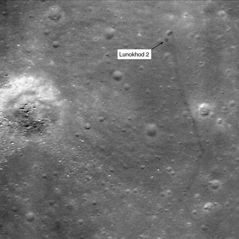
And that would not be so bad except that they had to promote it as 'our prof found a rover that had been lost for decades'. Suddenly this was picked up by other media and everyone knew about it. Obviously, VERY quickly, the correct story emerged and I had to deal with it. The next time I saw Sasha Basilevsky I apologised profusely, but he was very polite and forgiving about it. Memo to self - don't be stupid.
Tomorrow: back to reality.
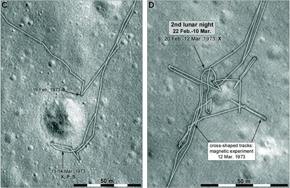
Here are two detailed maps of small parts of the Lunokhod 2 drive, this time from the 2nd lunar day, with the cross-shaped magnetic experiment tracks early in lunar day 3. The actual night position is a bit uncertain. It's great to have these wonderful images now, but the quest for something better never ends. Now it's 'we need 5 cm resolution to see details of the lander'. Oh, yes - and for geology.
#maps #moon #luna21 #lunokhod2
#maps #moon #luna21 #lunokhod2
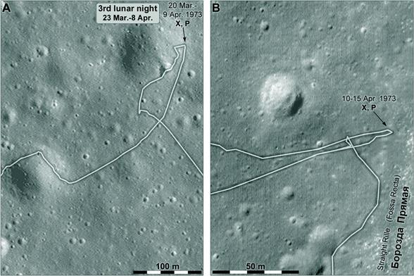
And 2 more maps like this. Here we see the third night location and the place where the rover arrived at the edge of Straight Rille, the long north-south trough.
We will have two more maps like these tomorrow.
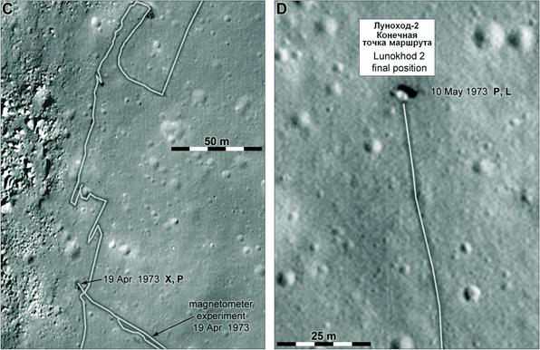
These are the final close-ups of this sequence of Lunokhod 2 maps. At left, a complex bit of driving along the edge of the trough. Some of the maneuvers may be for making stereoscopic pairs of panoramas showing the opposite side of the trough. At right, the last drive and final rover position. It seems the end was sudden and did not leave time for the laser reflector to be pointed at Earth. Its reflections are very weak. #maps #moon #luna21 #lunokhod2
Here is another look at the parked Lunokhod 2 rover, a slide from the presentation I linked to earlier in this thread. It shows the assumed orientation of the rover, though it's a bit of a puzzle still. I talked to the laser team, who are having trouble understanding how they get any reflection at all from the reflector in that orientation - it is part of the instrument section at the front (right end) of the rover. #moon #luna21 #lunokhod2
While we are talking about puzzles, here's another. At points marked 'S' on the maps a measurement of sky brightness was reported. Here's the citation:
Severny, A. B et al., 1975. The measurements of sky brightness on Lunokhod-2. The Moon v. 14, pp. 123-128.
They measured in visible and UV, both day and night. The UV sky was a bit brighter than expected, but the visible light sky was 'off-scale' bright and still quite bright after sunset...
Their conclusion: the lunar daytime sky is too bright for useful astronomy. Night would be OK. This is attributed to dust lofted electrostatically or by impacts, and scattering sunlight.
This might seem counterintuitive. Surveyor and Apollo observations show some apparent effects of dust but the LADEE orbiter did not find much. Maybe the new Firefly images will help. Was there contamination of the Lunokhod instrument? We don't know.
#moon #luna21 #lunokhod2
Early in our Lunokhod 2 sequence i gave a link to the Lunokhod 2 panoramas. Here is one of them:
https://www.planetology.ru/panoramas/images/big/lunokhod2_c/L2_D03_S05_P14m.jpg
Day 3, session 5, pan 14... it was taken at the south end of the triple traverse on 13 or 14 March 1973. One of my closeup maps shows that location with visible tracks around a crater. The crater is visible in this image. Across the crater are the day 2 tracks made on 19 February. My image here is a reprojection to show the tracks better. #moon #luna21 #lunokhod2
And with that I think we will close our examination of Lunokhod 2, a remarkable mission in many ways. This was only the second time any vehicle had been driven remotely on another world (the first being Lunokhod 1), and I would rank them and the sample return missions as the greatest achievements of the Soviet Union in lunar exploration, on a par with their Venus results and far beyond what they accomplished at Mars.
Tomorrow... another orbiter.
#moon #luna21 #lunokhod2
We move on to Luna 22, which was an orbiter similar to Luna 19. It was adapted from the design of the Lunokhod landing stage and rover, omitting landing legs, wheels and so on and adding various instruments and engineering tests. A basic description is given here:
https://nssdc.gsfc.nasa.gov/nmc/spacecraft/display.action?id=1974-037A
There was not a lot to say about Luna 19 but Luna 22 will keep us busy for a few days. We will see images, radar altimetry and bistatic radar data.
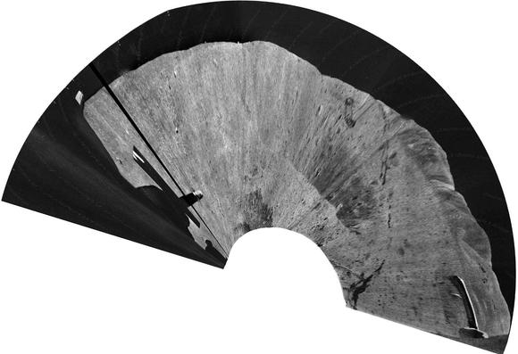
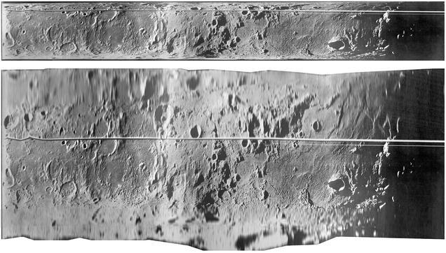
Let's look at the images first. They were produced by a scanner which scanned a line from horizon to horizon, successive lines being displaced by orbital motion. This image shows an example, with the raw scan above and a roughly projected version below, attempting to remove foreshortening towards the horizon. The area is in highlands south of Mare Tranquillitatis with Sinus Asperitatis at right. The line is an antenna or other object in the scanner field of view. #moon #luna22
How many Luna 22 images were there? We don't know. On the NSSDCA page for the mission (linked yesterday) there is a statement about what they have: "Panorama 1 consists of three sections and panorama 2 consists of five sections". When I was at the Sternberg State Astronomical Institute, Vladislav Shevchenko showed me what are probably the same negatives. If all published images are mapped we see what may be one section from a third 'panorama' or swath. #maps #moon #luna22
Actually there must be other panoramas merged into the overlapping area. Don Mitchell also has Luna 22 images here:
http://mentallandscape.com/C_CatalogMoon.htm
(near the bottom of the page) but they don't add any more to the map.
As with Luna 19, these images are not useful for studying the Moon and we can only make sense of them as tests of cameras designed for Mars or other places. Scanning imagers were flown on Mars 4 and 5. #moon #luna22
I scanned this map at MIIGAiK in Moscow in 2001. It had been annotated with landing sites and other information (C-5 is Surveyor 5, P-8 is Ranger 8). The L-22 lines are altimetry tracks but 2 of them end about 30 deg. south. The orbit inclination would not allow that. Then my hosts found an obscure paper:
Tyuflin, Y. C. et al., 1976. Nekotorie resultat radioprofilirovaniya s avtomaticheskoi stantsii Luna-22. Kartografirovanie Lune i Planet, pp. 54-58. MIIGAiK, Moscow.
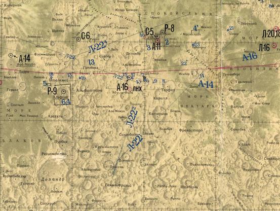
The paper cleared it up - some end-points of lines had been mis-plotted, not just in latitude but also confusing east and west longitude. The paper allowed me to draw the lines correctly. They match the pattern of images too, as you would expect. Only these tracks were made, again testing for planetary use. And we actually have the altimetry - which we will see tomorrow.
#maps #moon #luna22
#maps #moon #luna22
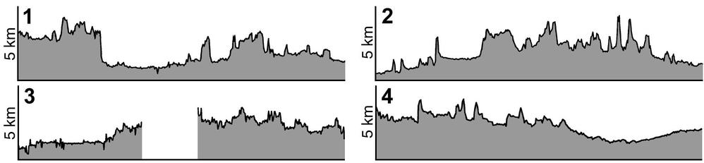
These are Luna 22 radar altimetry plots from that old Soviet-era publication. The vertical scale is shown, the same for each track. The plots match real features so we know they are correctly placed - number 2 crosses the large flat-floored crater Ptolemaeus, number 1 crosses Sinus Asperitatis and suddenly rises as it meets highlands to the west. Apollo altimetry was more extensive but did not cover this area (not until Clementine did we get our our first global topographic map). #moon #luna22
Here is another section of that Russian map I saw at MIIGAiK. The dots marked L-19 and L-22 are the important points here. At the time I didn't know what they were. Now I know they were radar observations made using the altimeters. I mentioned the Luna 19 points earlier - they are actually 2 contiguous tracks of radar reflectivity data. For Luna 22 we get actual bistatic radar images - we will see them tomorrow but don't hold your breath until then.
#moon #luna22
#moon #luna22
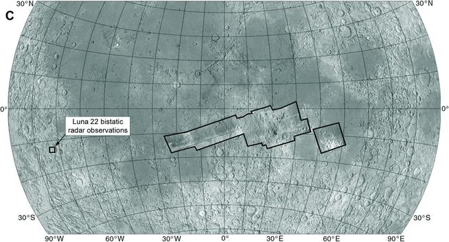
I will look at the Luna 22 bistatic radar observation in more detail than it probably deserves because it is so little known. It was made at a crater called Rocca, involving 3 observations as the orbiter passed overhead. Here is the citation:
Zaitsev, A. L. et al. 1977. Bistatic radar surveillance of the moon, using a modulated signal. Radiotekhnika i Elektronika, v. 22, Oct. 1977, p. 2097-2104.
A friend helped me find it in the Lenin Library. #moon #luna22
Zaitsev, A. L. et al. 1977. Bistatic radar surveillance of the moon, using a modulated signal. Radiotekhnika i Elektronika, v. 22, Oct. 1977, p. 2097-2104.
A friend helped me find it in the Lenin Library. #moon #luna22
This is what the 'pictures' look like. The black marks are bright reflections. The pattern drifts across a grid fixed to the spacecraft as Luna 22 passes over the crater. A-B is an axis of symmetry and the image is north-south ambiguous across it. You can't tell if a specific reflection comes from north of the line or south of it. What can we do with this? Let's look at the Rocca crater area. #moon #luna22
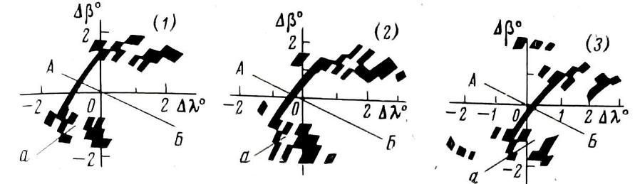
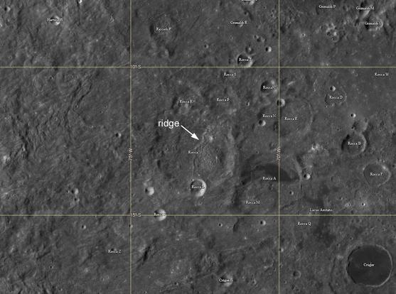
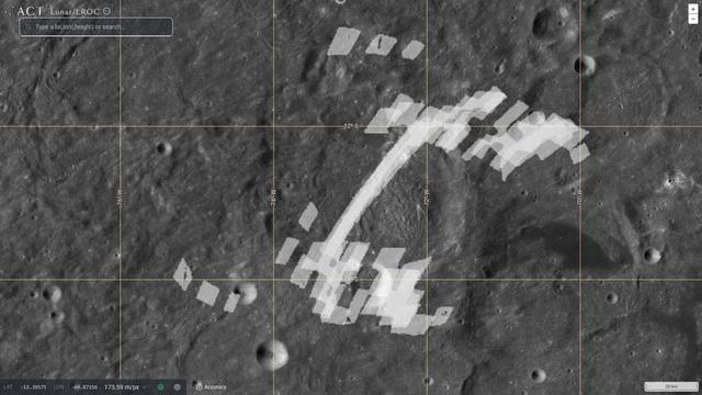
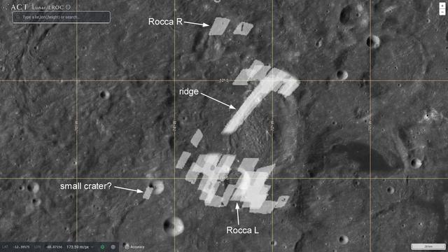
Here is Rocca, a c. 60 km diameter crater at 13 south, 72 west, mantled by Orientale ejecta. A ridge crosses its floor where Orientale ejecta has piled up against the downrange crater wall. A fresh smaller crater sits on Rocca's southern rim. The straight line in the radar image is that ridge, and strong reflections at the south end are from the rocky ejecta of the smaller crater. I made a composite of all 3 radar images to overlay on the crater... #moon #luna22
(My interpretations here are from the Russian paper). If the bright reflection at the bottom is that crater ejecta, we can remove its ambiguous 'echo' from the top (next post). Some reflections at upper left may be from the north wall of Rocca R so their echoes can be removed at bottom left. One bright spot at lower left might be from a small fresh crater, so it is retained but removed at top left. It's a bit ad hoc but the best we can do. #moon #luna22
This is the image with some of that ambiguity clumsily removed. It's not just images, we also get surface roughness estimates. But is it useful? The interesting thing that comes from this is that a year after Luna 22 did this, the method was used at Venus by Venera 9 and 10 (more famous for their surface images), where it was the only way to get such details of the surface. Again, these lunar orbiters were testing methods for planetary exploration. #moon #luna22
Time for a quick look at Luna 23, a failed sample return mission. Here are some details:
https://lroc.im-ldi.com/images/461
This starts with Luna 24 and looks at the earlier lander lower down the page. An annotated image shows what seems to have happened. The lander came in with some sideways velocity and toppled over... rather like some recent landings. It was able to communicate and even to operate its drill but couldn't collect a sample (also like IM-2). #moon #luna23
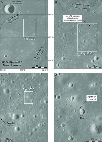
Here is a context map of the landing area in Mare Crisium. it is about 200 km south of the recent, very successful, Firefly Blue Ghost 1 landing site. Highlands about 50 km south of the site might have been visible but there was no camera on the lander. #moon #luna23
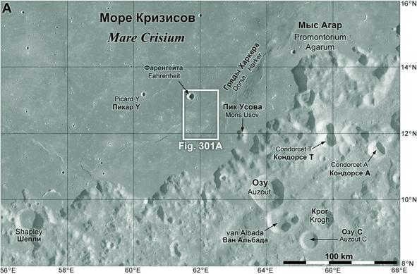
This detail from my lunar sites map shows the Firefly site as well as the nearby Luna missions. As noted earlier, the Luna 15 site is very uncertain with several suggested locations. After the Hakuto M2 landing attempt I will release a new version of the whole map. #moon #luna23 #fireflyBGM1

These maps zoom in on the landing site of Luna 23. I think I am repeating myself here, as we did cover this in the lunar landing site sequence. Speaking of.. I guess that will need updating later this year. I am hoping Hakuto M2 'Resilience' will land safely in 4 weeks and there could be 2 more attempts later this year.
#moon #luna23
#moon #luna23
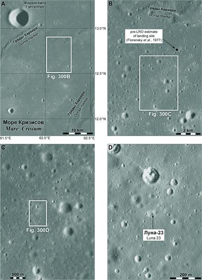
Here is a close-up of Luna 23. It toppled and lies on its side with the return capsule at the upper right end. When LRO images first showed this the white object was interpreted as possibly a rock which the lander grazed while landing, damaging the drill. I think the fallen lander interpretation is probably correct. The area brightened by the landing rocket is hard to see on the south side and I may have taken it too far out. #moon #luna23
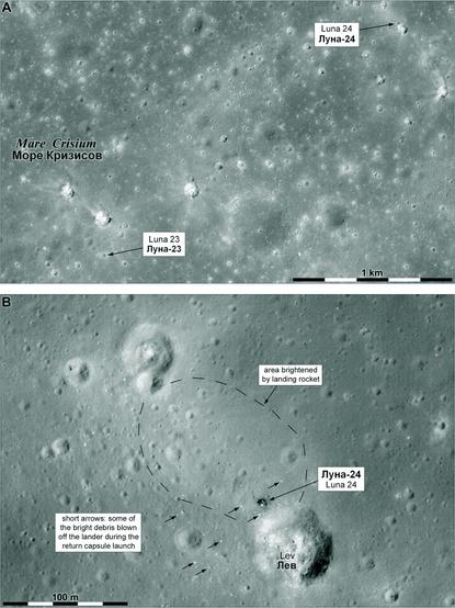
Only 2 km northeast of Luna 23 is Luna 24, the last of the Soviet-era missions (but I will end this with Luna 25 and a look ahead). It was a successful sample return mission. The samples didn't quite seem to match the remote sensing data for the area and the LRO image suggests why - Luna 24 landed on the rim of a fresh crater called Lev, whose ejecta is not space-weathered (by micrometeorites and solar wind) like the average surface. There is still some uncertainty... #moon #luna24
Some Russians have argued that 23 and 24 are transposed in the interpretation I have given:
Kaydash, V. et al., 2013. Landing of the probes Luna 23 and Luna 24 remains an enigma. Planetary and Space Science, 89, pp.172-182.
Velichko, S. et al., 2022. Photometric analysis of the Luna spacecraft landing sites. Planetary and Space Science, 216, p.105475.
I don't find the argument convincing but it should be acknowledged.
Wrapping up Luna 24 with a zoom in to the landing site. This was a different design than the Luna 16/20 landers and it had no camera. The drill was fixed to the side of the lander to improve its ability to push down into the ground, so there was no need to view the sampling area to look for hazards. As an imaging person I can only say - tragic! I want pictures...
Tomorrow: Luna 25, and then I will look at Russian plans for future missions. #maps #moon #luna24
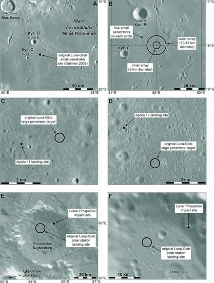
We don't know much about landing site selection for Soviet-era landers, and what little I know I have mentioned already. That changes with modern landers, where many studies have been reported. Luna 25 is an interesting case. The mission went through several iterations and names, beginning with Luna-Glob. Glob = 'globe' and this was supposed to be a global geophysical network mission:
Galimov, E.M., 2005. Journal of earth system science, v. 114, pp.801-806.
The next mission was going to be Luna-Resurs (= resource), which would study potential lunar resources such as polar volatiles. Later Luna-Resurs was taken as the name of a sequence of landers and Luna-Glob was the first of them. Later still the sequence took the names Luna 25, 26, 27 and so on to show continuity with past missions. India joined for a while with an Indian rover on a Russian lander so the name Chandrayaan was used too.
#moon #Luna25
#moon #Luna25
These are the first set of sites for Luna-Glob. Two circles of small penetrators and two large penetrators carry geophysics instruments (proximity to Apollo sites is to match new data to old more easily). A polar lander goes to a shaded site in Shoemaker crater near the pole. The polar resources became the most important part of this later.
#maps #moon #Lunaglob
#maps #moon #Lunaglob
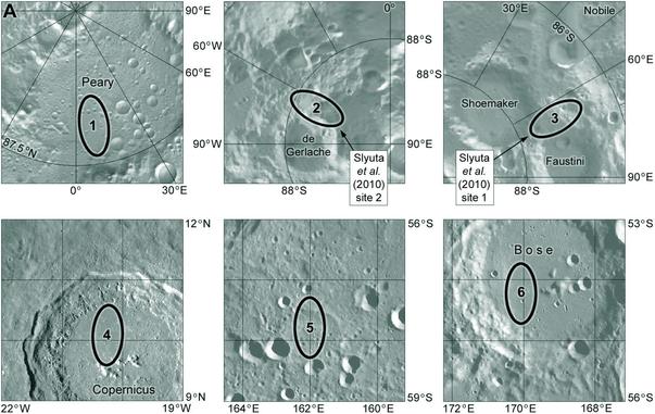
By 2009 the next lunar mission was called Luna-Resurs (resource) and site selection was moving towards the poles. Landing sites were described by Evgeny Slyuta and colleagues in 2009 and 2010. The 2009 set of 6 sites had 1 near the north pole, 2 near the south pole and 3 at low to mid-latitudes if polar sites were too challenging (Copernicus, and 2 in the South Pole-Aitken basin). The 2 south polar sites were preferred in 2010.
Then in 2011 two international workshops were held in Moscow - with presentations still online today:
http://www.iki.rssi.ru/conf/2011-lg/
(open page in something that will translate it for you if necessary, but many of the presentation PDFs are in English).
They included proposals for sites at north and south poles. These maps show both sets as well as some later additions. All the modern datasets and GIS analytical tools are used, a big change from the old days!
#maps #moon #lunaglob
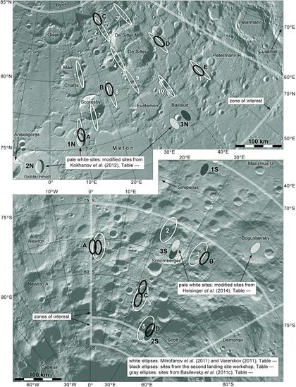
One very important data source for this site selection work was the Russian LEND neutron detector flown on Lunar Reconnaissance Orbiter. Its results can be interpreted to reveal hydrogen in the surface materials. Most or all of these landing sites are in areas of higher hydrogen content. Some are too rough or steep and would be dropped later.
In 2015 our mission was still being called Luna-Glob, and site work had converged on one place, the 90 km wide crater Boguslawsky at 73 south. This map shows two ellipses described by Ivanov et al. in Planetary and Space Science. They are in view of Earth all the time and are in the smoothest parts of the floor. Craters with flat floors like this should have central peaks, so in this case any peak is buried under the material of the crater floor. #maps #moon #lunaglob
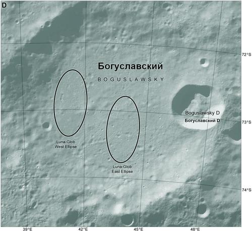
Here's a bit of a problem. The crater floor is thought to be made of debris thrown in from other impacts, so we don't really know where it came from. But the East Ellipse would sample ejecta from a smaller crater (Bog. D) which has excavated the wall and rim of Boguslawsky itself. So we do know where that came from and that ellipse was preferred.
#moon #lunaglob
#moon #lunaglob
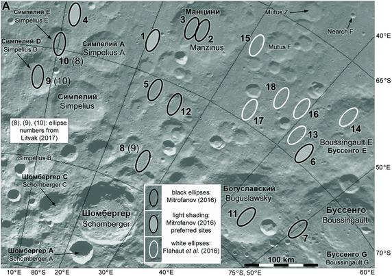
That landing site in Boguslawsky was not the end of the story. This map shows 2016 site study results by Russians and by a group led by Jessica Flahout. It might seem similar to the last few posts but check the latitudes. The 2010 sites were around 88 south. The 2011 sites were at 75-85 south. The Boguslawsky sites are at 73 south. These are 65-75 south and the preferred ellipses are about 68-69 south. The poles are tricky.
#maps #moon #lunaglob
#maps #moon #lunaglob
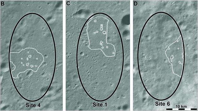
I'm showing these maps to illustrate the number of sites suggested over the last 15 years for Luna 25 and its precursors. By about 2018 the mission name was settling on Luna 25. The 3 sites shown as preferred are the final sites, shown in this map in more detail. Site 6, north of Boguslawsky, was the primary landing site for Luna 25. White outlines show safest areas in the ellipses from a 2021 study. Now we can move on to the actual mission.
#maps #moon #luna25
#maps #moon #luna25
At last we get to Luna 25 itself. It would have been an interesting mission. Here is the NSSDCA page for it:
https://nssdc.gsfc.nasa.gov/nmc/spacecraft/display.action?id=2023-118A
A robotic arm would collect a sample from a small workspace close to the lander and deliver it to the lander for analysis. This would be repeated once a month for a year. But it was not to be. Flight control issues caused a braking overburn which caused a crash northeast of the target site. This map puts it into context.
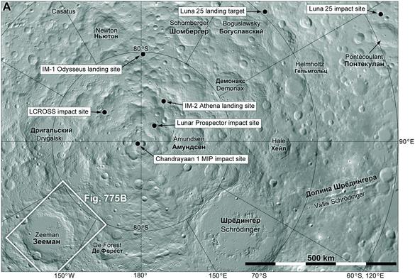
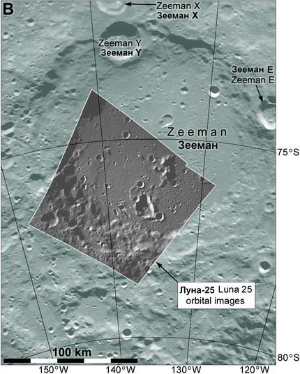
This map shows the crater Zeeman, location of the only images known to have been taken from orbit. Surface composition was measured by one instrument but I have not located the observation site yet. A dust detector collected data in orbit 2 days before the crash. So there was some small science return from the mission.
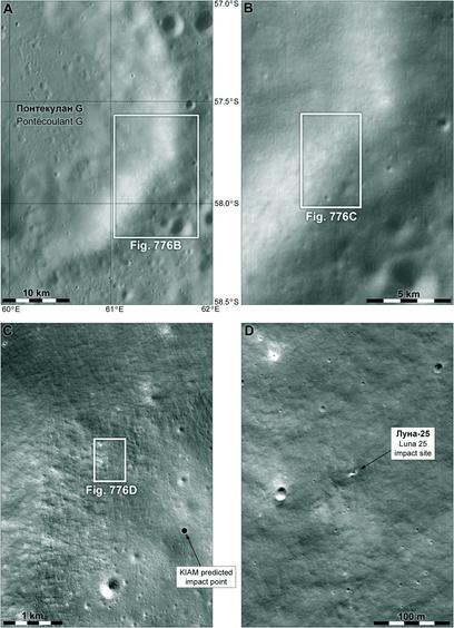
Here we zoom in on the Luna 25 impact site. The location was shown in the context map yesterday. How do we know this is the impact site? Here is the LRO camera page on it:
https://lroc.im-ldi.com/images/1311
The location was predicted by mathematicians at the Keldysh Institute, and 2 km away is a small crater with a south-facing spray of ejecta which was not there 2 years earlier. It's what we expect, close to where we expect, so very likely to be the impact.
#maps #moon #luna25
Luna 25 Impact Crater
During the descent to the surface, the Russian spacecraft Luna 25 experienced an anomaly that caused it to impact into the southwest rim of Pontecoulant G crater on 19 August 2023 11:58 am UTC (14:58 Moscow time). Image is 1100 meters wide, north is up, LROC NAC M1447547309R [NASA/GSFC/Arizona State University].
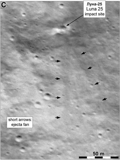
Here's a closeup of the Luna 25 impact site. All these impacts from orbit show a faint downrange ejecta fan, not the roughly symmetrical bright ejecta expected for a natural hypervelocity impact. One very important factor here is LRO which has imaged basically the entire surface of the Moon multiple times, so there is pretty much always going to be a pre-impact image, often with similar lighting.
Tomorrow - a quick look ahead to Russia's future lunar plans.
We are up to date with our Russian lunar missions, but let's look ahead a bit. The next mission is likely to be Luna 26, an orbiter bristling with instruments:
https://www.russianspaceweb.com/luna_glob_orbiter.html
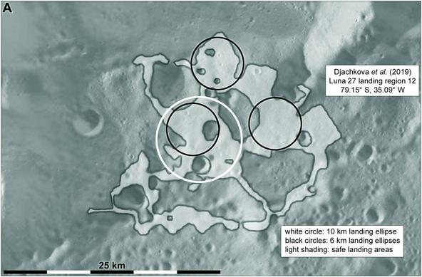
It might fly in 2027 but timing is very uncertain. After that there two landing missions (possibly 3 landers), Luna 27 and 28. The attached map shows a 2019 version of a set of Luna 27 landing sites by Maya Djachkova et al. It illustrates an important point...
#maps #moon #luna27
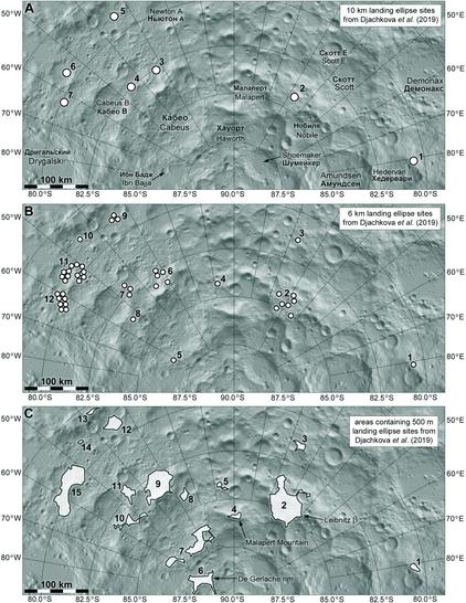
... and that point is, smaller landing ellipses are easier to locate. The basic pattern is controlled by hydrogen abundance, and in H-rich areas the big (10 km) circles only fit in a few locations. Smaller circles (6 km) are easier to fit in low slope areas. Drop to 500 m diameter and hundreds of sites might work, so they are mapped as irregular areas containing many sites. Precision landing is a game-changer for future missions.
#moon #Luna27
#moon #Luna27
Here's an illustration of this point about smaller circles, using an example redrawn from Maya Djachkova's presentation on Luna 27 at a symposium in Moscow in 2020. The irregular light area is mostly safe to land in, a few small craters excepted. Lots of 500 m circles could be squeezed into it. But only 3 spots can take a 6 km circle (and they are not perfect), and only one 10 km circle is possible.
#moon #maps #luna27
#moon #maps #luna27
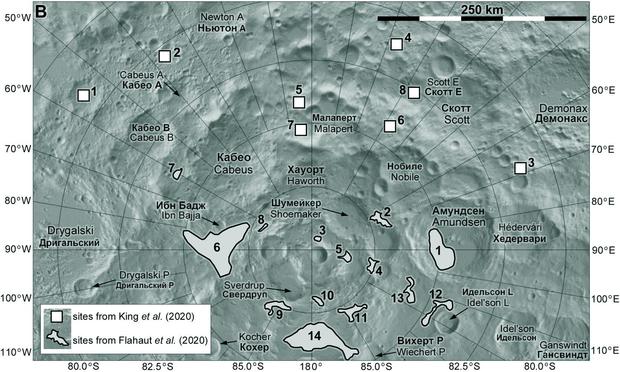
Other people also studied Luna 27 landing sites. This map shows two sets of sites from 2020 papers. King et al. studied Luna 27 sites on a list provided by ESA, which was to fly a payload called PROSPECT to look for volatiles. ESA cancelled that after the Ukraine war started, and it will now fly on a CLPS lander. Flahaut et al. looked at many sites and identified some suitable for Luna 27. They preferred site 6 near Ibn Bajja crater.
I want to give a view into the complexity of site selection work for these missions. The datasets are amazing, the mapping tools magical to someone like me who trained with ink pens on mylar. And to follow the story you need to spread the net wide - journals, conferences and workshops, social media. It's a full-time job trying to record it all! Here is the next step for Luna 27, M. Djachkova's paper - updated from the 2019 symposium. Similar but not identical.
#maps #moon #luna27
#maps #moon #luna27
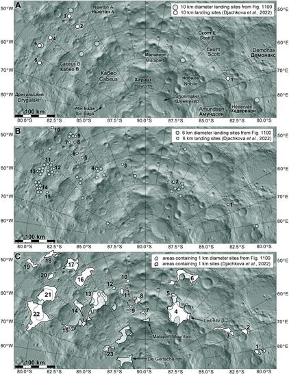
Sharp-eyed readers will note a discrepancy - the bottom panel mentions 1 km diameter sites from Figure 1100 (that's a placeholder figure number from the 2019 iteration). But that map mentions 500 m circles - is it radius or diameter? Now I have to resolve this contradiction.
Meanwhile, here is a 2024 study with completely different results. 5 big ellipses, 10 small circles (this time 500 m radius). Who knows where the lander will actually go? Even more tomorrow...
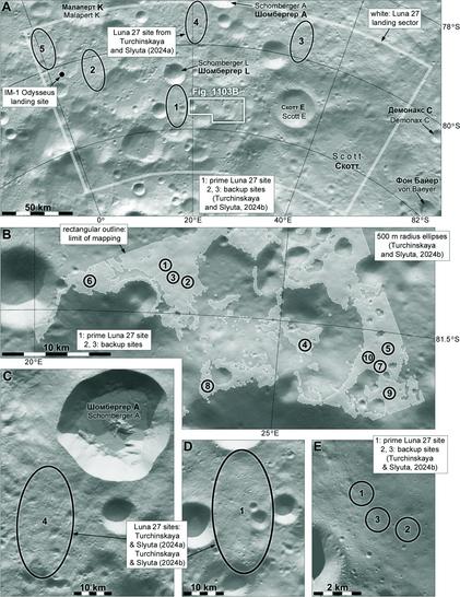
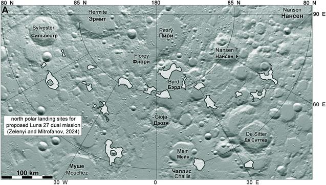
The latest version of the Luna 27 mission involves two identical landers, so if one fails there is a second chance. If a south polar landing is successful the second lander could go to the north polar region. This map shows sites considered for this purpose, from a symposium in Moscow in October 2024. I'm not sure the second lander is approved but planning is proceeding.
With that I will end this look at Soviet and Russian lunar exploration. I hope you have found it interesting, and perhaps found something new in it. Tomorrow I will start a new topic, and I think it's time to go back to Mars. Later in the year I will do a special sequence looking at the recent moon landers.
@PhilStooke very interesting, thank you!
@PhilStooke Impressive coverage of decades of lunar missions. Will this be part of your next book?
@GeoffRichards Hi, Geoff. It is indeed taken from my new project, which will be distributed as a series of free PDF downloads, beginning about the end of this year. Still some details to work out on hosting.
@PhilStooke Looking forward to seeing them.
@PhilStooke May I gently ask whether '2029' is a typo?
@birchbirch It's a good job somebody is factchecking me! I corrected my mistake.