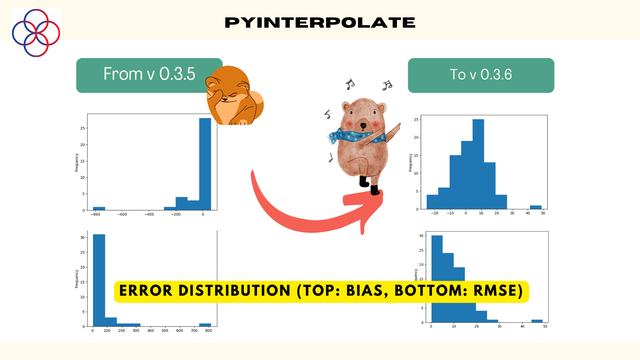
The new release of #pyinterpolate for #spatial, #geospatial, #gis, #mapping is out. It has been a significant change in Poisson Kriging algorithms used for areal data interpolation and transformation, and now interpolation errors are an order of magnitude lower than in the past releases. Release 0.3.6 closes some chapters of development, and release 0.3.7 will be devoted mostly to CI/CD, dependencies, and documentation, then we skip to version 0.4 with indicator kriging.
A new tutorial is available for users with detailed instructions on how and why to use ExperimentalVariogram and VariogramCloud classes. It is the most critical step of data exploration before modeling and interpolation. Thus, a good understanding of API and theoretical background is required, and this tutorial fills the gap.

The next minor release of pyinterpolate is out! Version 0.3.7! There are many enhancements that have been implemented. You may check a complete list here: https://github.com/DataverseLabs/pyinterpolate/blob/main/changelog.rst

For now, I'm working with features that will be introduced in the next release (0.4):

- gridding (aggregating) points,
- cross-validation function,
- cluster detection,
- spatial dependency index,
- indicator kriging.

When it's done, the new MAJOR release will be introduced.

pyinterpolate/changelog.rst at main · DataverseLabs/pyinterpolate

Package with spatial analysis and spatial prediction tools - DataverseLabs/pyinterpolate

GitHub