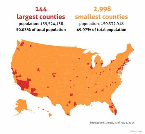
Half of all Americans live in the red counties, half live in the orange counties
@conradhackett just as our founders envisioned!
@conradhackett for those who are not hip on the SIZE (in total area) of some of the counties in SoCal... there aren't people spread all through that area, all that red just reflects one or two cities in those HUGE counties. But yeah, it still is really amazing how it all "maps out"
@conradhackett As we say in the red counties, 'dirt doesn't vote'.
@conradhackett this is very enlightening, thanks for sharing it
@conradhackett Two of three Orange Counties
are red, the third orange.
@conradhackett wow that's got to be a big blow to proponents of "land don't vote"
@conradhackett
J'aime bien les cartes géographiques qui signalent des phénomènes qu'on ne voit pas d'habitude. Celle-ci explique assez bien la domination des Républicains malgré leur nombre inférieur.
@conradhackett we can obviously fit many more people
@msignorile @conradhackett My thought exactly. Imagine if we could learn to share resources.
@msignorile @conradhackett Can, but probably shouldn't. It takes a lot of land equivalents to support a modern human. Shooting for the replacement rate with healthy immigration would likely be our best position.
@conradhackett and the big red area in the southwest doesn't have enough water to sustain that many people, let alone grow enough food for the rest of the orange area. 😦
@conradhackett once again a good reminder that land doesn't vote, people do.
@conradhackett and the superposition of average and top wealth and political sides would be interesting
@conradhackett Woah... I read that half of America lives in Orange County 
@conradhackett So, a sixth of a billion people live in the red area. Impressive!
@conradhackett a bit too dated, aren't we?
@conradhackett I find this visual depressing every time I see it.
@conradhackett I was confused by this because usually when I see maps like this, they're coloured red and blue and have way different subtext
@conradhackett And yet...every State gets 2 Senators....doesn't seem quite fair to me.
@conradhackett The Russian Federation, and the United States of America, are very similar.
@conradhackett All my immediate family lives within one of those red spots, but scattered from east to west coast.

@conradhackett I love what @owillis wrote about the political ramifications of geography this week. His messaging is really on point. I urge everyone to read it.

https://oliverwillis.substack.com/p/republicans-are-out-of-touch-with?r=173pk&utm_campaign=post&utm_medium=web

Republicans Are Out Of Touch With Urban And Suburban America

The GOP Is Simply Not A Contender In The Areas Where Most Americans Live

Oliver Willis Explains
@conradhackett I've never quite understood why those in rural counties are more likely to vote for the GOP

@markrvickers

I've moved back and forth between those kind of areas for decades, and have wondered.

I've got some idea as to why, now.

@conradhackett

@conradhackett How many of the various Orange County are orange?
@conradhackett

Some of the red areas are going to be completely unlivable due to climate change by 2050. How do we convince everyone to move?
@HaplogroupNews @conradhackett SoCal shouldn't even exist as it does now in a "normal" climate
@conradhackett The political implications are mindboggling
@conradhackett Impressive map. I think I counted 13 states that do not have counties with large populations, and yet they get 2 senators each just like the populous states.
@conradhackett I see you've left out the 1% of us who live in Puerto Rico, which might have one or two of your red counties, not sure what the population cutoff is. But Bayamon or Santurce municipios might make the cut.
@conradhackett
Your daily reminder that land doesn't vote.
@conradhackett Now tell us why there are so many counties to begin with.
@conradhackett and yet all that dirt is able to control the Senate and block all American progress in favor of a white nationalist fascist state.
@conradhackett and if this were mapped at the census tract or block level, the red area would be even smaller (and show slightly different places)
United States census geography—Related Concepts | Documentation

Fundamentals of United States census geography.

@conradhackett it really does help one's perspective to drive across the country once.
You realize "we're out of room" is a specious slogan.
Our constraint is water
@conradhackett And fascinating how 13 states don't even make the cut at all
@conradhackett That big red blob between LA and LV is why the Colorado River and Lake Mead are dry AF. #overpopulation
@conradhackett dang I live in an orange one and there’s already too much traffic. 😭