Openstreetmap is reaching the point that it is just more information rich and beautiful than google maps and that is awesome
@Alonealastalovedalongthe the only thing thats really missing now is a good Openstreetmap app
@Sentry @Alonealastalovedalongthe On Android I have been using OsmAnd for some time now and it's just amazing - the full-featured app at least :)
@phel @Alonealastalovedalongthe thanks for the info, I am suprised I never found OsmAnd
@Sentry maps.me is ok-ish.
@mondstern @Sentry what's its full name? "maps" is too generic for me to find it
@mondstern oh yeah! that's actually the one I use
osmand is good and is getting better and better over time
the only missing feature compared to gmaps is real time traffic
https://osmand.net/
install from fdroid recommended
@Sentry
OpenMultiMaps https://f-droid.org/app/app.fedilab.openmaps
By @tom79 créatif of #fedilab
@Sentry @Alonealastalovedalongthe
#OsmAnd is a great App. It has a lot of features, works offline and has easy Lat/Lon input.
I used it for my one year trip around Europe. In many countries the quality of information is much better than Google, e.g. Georgia.
Privacy wise it seems good, too.
@Alonealastalovedalongthe I've added two benches along the beach and slightly tweaked the bend of a road. No idea why but I'm glad others are doing it too. 😊
@Alonealastalovedalongthe My issue with #OpenStreetMap is that the search is so poor.
I can enter, say, Lat/Lon coords into Google Maps, and get a pindrop on that spot. OSM has NFC what I'm talking about.
Searching by location name is similarly disappointing. Google does get context and relevance in ways OSM doesn't.
And for the record: I'd vastly prefer to entirely replace Google Maps. Not entirely yet.
OSM's overlays are noice though.
I 100% agree, I get fuming mad everytime I search for something and get sent all the way across the world
The data seems like it is there though, it just needs better search
@dredmorbius @Alonealastalovedalongthe
I have also noticed the search function on openstreetmap.org is not always the best. Are there any projects to improve the algorithm?
I have also noticed the search function on openstreetmap.org is not always the best. Are there any projects to improve the algorithm?
@hinton @dredmorbius @Alonealastalovedalongthe The software behind the search box on OpenStreetMap.org uses software called Nominatim ( https://wiki.openstreetmap.org/wiki/Nominatim ). “Searching addresses” is called “geocoding”, there aren't many tools that do that ( https://wiki.openstreetmap.org/wiki/Search_engines ).
The search box on osm.org first goes through a few local processing, if there's a bug you can file issue there ( https://github.com/openstreetmap/openstreetmap-website )
@hinton @dredmorbius @Alonealastalovedalongthe BTW I've never tried putting a geo coordinate into the search box on osm.org. You might be able to get inspiration on how to fix/improve it from a controversial suggestion add OLC to the search ( https://github.com/openstreetmap/openstreetmap-website/pull/1818 ), it's the first thing that comes to my mind
@Alonealastalovedalongthe Actually, trying lat-lon search just now: it's *really* inconsistent.
Several coordinates landed precisely on the intended spot. Then suddenly I'm a thousand km off. For no apparent reason.
check Osmand (for Android)
lat/lon searches and pindrop as you like
location searching is not as advanced as in gmaps
but still gets most of the cities,towns, streets
plus thousands of useful Point of Interest
and all of this while offline
very useful when traveling to other countries with poor or no internet connection
@essenne
As written above: Location sin Google are incomplete. Many named, small places I visit are not in Google maps at all. @dredmorbius @Alonealastalovedalongthe
As written above: Location sin Google are incomplete. Many named, small places I visit are not in Google maps at all. @dredmorbius @Alonealastalovedalongthe
@dredmorbius @Alonealastalovedalongthe If ever I need to go a specific lat/lon I just change the URL e.g. https://www.openstreetmap.org/#map=18/34.33937/-78.71000 Does that not work for you?
@rory It does, and I've resorted to doing that. It's not a great UI, and being able to paste lat/lon into the site's search bar *really* should Just Work.
@dredmorbius @Alonealastalovedalongthe yeah it should work. Do you want to file and issue for ths search box to support that? I can help if you'd like?

@dredmorbius
Many small places I visit are not in Google Maps at all. OSM knows them and I can search them perfectly.
@Alonealastalovedalongthe
Many small places I visit are not in Google Maps at all. OSM knows them and I can search them perfectly.
@Alonealastalovedalongthe

@Alonealastalovedalongthe I think some of what you're seeing is bc google and osm style things differently at different zoom levels. Eg parcels/buildings show up when u zoom further down on google. But, it is pretty awesome that the two are even comparable!
@Alonealastalovedalongthe the funny thing is that, through Osmand, OSM users can switch from one map style to the other at the tap of a button
@Alonealastalovedalongthe They've always been the closest thing to Ordnance Survey paper maps I could find.
@Alonealastalovedalongthe I use #openstreetmaps and contribute data to it. I'm an advocate for all #GNU #FREE and #Opensource software and use as much of it as possible. Visit http://openstreetmaps.com and download the app for your phone.
Wtf is this
Is this a bot?
@Alonealastalovedalongthe no I'm human
@Alonealastalovedalongthe
What is to prevent Google from using osm data updates to update its own data? Or even shift to osm hypothetically? Users wouldn't care about a ©osm in some corner.
@devurandom
What is to prevent Google from using osm data updates to update its own data? Or even shift to osm hypothetically? Users wouldn't care about a ©osm in some corner.
@devurandom
At the very least that would be very embarassing for google
@Alonealastalovedalongthe map shouldn't be information-rich, it should be readable. For example, cars don't need pedestrian pathways. OSM default render style is way behind than commercial apps on that.
Good point, but there in lies the problem. There isn't necessarily money in making and maintaining an information rich, beautiful map for purposes other than navigation.
One of the reasons I see so much potential in openstreetmaps is there is so much more potential in maps than just navigation and search. Yes those are the main commercial opportunities in mapping (that we know of now) but I think we are just scratching the surface of what digital maps can be.
1/2
The act of a community crafting a map that represents it reaches down into the roots of the creation of that community itself.
I see a little kernel of this in how parks, the most literal of community spaces, are often very precisely mapped on openstreetmap whereas on google maps they are more of a background feature.
From google's perspective parks are the spaces between businesses but to openstreetmap mappers they are an obvious valuable thing to map.
2/2
@Alonealastalovedalongthe I've love the cartographical quality, reminds me of Ordnance Survey, so detailed and clear.
@Alonealastalovedalongthe It has been much better for me in most cases for years.
I use the map on my Garmin GPS where at least in the places I have been it has been hugely beneficial as it shows most small tracks and detailed information where Google Maps only shows roads.
For more general desktop use it depends, but it tends to show more information and detail.
It lacks behind for routing (osm.org) and stuff like current traffic reporting.
House numbers are often off no matter what.
@Alonealastalovedalongthe Please don't confuse the OpenStreetMap project with the default map layer displayed on osm.org (or any other map). I agree it's not obvious from outside, and the name might be a bit misleading, but OSM really is a database which can be used to create maps, but not a map itself. It has more information than you can display on a map, therefore a lot of different maps for different purposes exist.
@Alonealastalovedalongthe this one (from the default web editor) shows the points and lines present in the same area as your screenshots, but doesn't show all the attributes each of them have.
@Alonealastalovedalongthe this wiki page has a very incomplete list, yet still over 360 maps:
@Alonealastalovedalongthe also note that the different map layers / design of the map, search, routing, displaying information, and other map tools are separate things and often done by entirely different pieces of software. It uses the OpenStreetMap data, but none of those software pieces "are" OSM.
@Alonealastalovedalongthe the osm.org website hints at this by showing search "Results from OpenStreetMap Nominatim" and "Results from GeoNames"and giving you 6 different options for routing software when you use directions on the website.
Hope this helps, feel free to reach out if you have questions. Or start improving your area (from your couch!) at https://www.openstreetmap.org/edit :)

Oooh that makes a ton of sense, but I hadn't thought about it. Thanks for pointing that out!
@Alonealastalovedalongthe @FreePietje I have a really hard time using it though. When I try to navigate to a restaurant or so with it, (1) it never knows about the restaurant of course, but fair enough, (2) multiple times when I write the full address verbatim it can't find it (#OsmAnd vector maps).
Any suggestion for a restaurant searching app that can open in OsmAnd or another #OSM app directly?
Any suggestion for a restaurant searching app that can open in OsmAnd or another #OSM app directly?
@stevenroose @Alonealastalovedalongthe If you have an 'address' that starts with 'geo:' (and then lat/long values), you should get an option to open it in osmand.
With searching I have mixed results. Sometimes no problem, but other times it has problems. Usually I try to place commas to see whether that helps.
I could very well be that I'm doing it wrong (as I'm not doing it often). You could try asking on IRC #osm on oftc.net
With searching I have mixed results. Sometimes no problem, but other times it has problems. Usually I try to place commas to see whether that helps.
I could very well be that I'm doing it wrong (as I'm not doing it often). You could try asking on IRC #osm on oftc.net
@FreePietje @Alonealastalovedalongthe I know about the geo: URIs, but I believe Google is heavily pushing for them to not be used. Many companies/websites just give you either Google Maps links or even an embedded Google Maps frame you have to click on. I could try searching in DuckDuckGo next time, but they might give me an Apple Maps frame. Perhaps the link is geo:. Just a good index like Yelp doing geo: would be so awesome.
@Alonealastalovedalongthe I find myself having trouble finding things on google maps, just because the rendering is often so bland with little distinction for different kinds of features. Sure, you can get simpler OSM renderings too, but most of them have more differentiation, still.
@Alonealastalovedalongthe flip side: I wanted to get OSM attribution on a presentation I'm doing to push it at work - and the data is probably the best, too.
But: the data that OSM hold is pretty poorly sliced, and the only way to get "all roads in Europe" is to download tens of GB of world data and filter it myself.
OSM would do well to make a point of producing common datasets ahead of time and making it easy for people to use them.
@Alonealastalovedalongthe (In the end, the European Union had the best data, so they'll be the ones getting their name on the attributions slide  )
)
)For general browsing or when just trying to get a sense of "place", I agree. It's impressive how far it comes.
Unfortunately, I don't know of a good iOS app for mobile use and haven't had a chance to investigate OSM's navigation features.
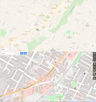
@Alonealastalovedalongthe Here is an example where Google Maps fails terribly:
The destination marked on the left map (OSM) is at a small street, just across the railway track. Try to spot it on the right map (Google). Barely a chance since the railway track is hard to get, no houses and no names.