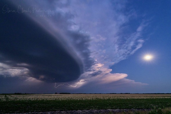
Laura Hedien - Storm photography gallery

Photographer, stormchaser and nerd from the U.S.

EXTREMEWEATHER.CLUB

An older photo from May 2018 (somewhere in #Oklahoma). It was one of the most beautiful #Mammatus displays. We didn't want to stop photographing as the appearance of the clouds and the atmosphere were in a constant state of change.

#PhotoMonday
#SupercellSunday
#StormChasing
#Photography
#Clouds
#Weather

Sometimes the hours after a severe weather outbreak are the more photogenic ones. So it was on May 27 this year in South Dakota.

#SupercellSunday
#WxMastodon
#FediWx
#Photography
#Sunset
#Rainbow
#StormChasing

For #SupercellSunday, here's a shot of the Tescott (2018) supercell 1.25 hours before it became tornadic.

On today's #SupercellSunday, I'm showing you the long-lived #Supercell of May 23, 2022 in NW #Texas. It produced the legendary #Morton #Tornado as a classic supercell. At the time of both shots, the cell had already transformed into a huge HP. The conditions for taking pictures were very bad: the inflow storm blew hard and drove huge amounts of dust towards the storm - and in our faces, camera bodies and cars ;-). But it was worth it!

#StormChasing
#WxMastodon
#FediWx
#Photography
#Nature

On today's #SupercellSunday, I'm sharing a photo the May 14, 2018 Arkansas City, #Kansas tornadic #Supercell. We were very lucky to follow the cell from birth to death. The photo shows the funnel cloud of the first tornadic cycle. It was followed by several more in the hours after.

#Tornado
#StormChasing
#Photography
#WxMastodon
#FediWX

Front and back of a classic #supercell near Walsh in southeastern #Colorado. The cell was dying, but nevertheless a very special atmosphere revealed itself to us. Including a decent dust storm on passage of the RFD.

#supercellsunday
#StormChasing
#Photography
#WxMastodon
#FediWx

Hooray! It's #supercellsunday!
Today we are heading to #Dalhart, #Texas. On May 15, we were able to intercept an HP #supercell that had an extremely high #lightning frequency. The CG flashes were striking every second from the shelf cloud towards the ground. Thus, a discharge made it on almost every photo. However, we were constantly on the run from a dusty outflow boundary. In the end it drove us all the way to southwest #Kansas.

#WxMastodon
#Wxtoots
#StormChasing
#Photography

Der @al_meteo hat vorhin mit dem #supercellsunday angefangen, also habe ich auch mal gekramt.

Das letzte große Highlight bei mir in der Wetterau (ich komme ja nicht in die Plains) war abends am 7.6.2019 - vermutlich nicht lange genug, für die Superzelldefinition, aber immerhin mit Rotation über ein paar Termine hinweg und optisch ziemlich eindrucksvoll.

Radar dazu: https://kachelmannwetter.com/de/regenradar/wetteraukreis/20190607-1740z.html

Radar HD+, Regenradar vom 07.06.2019, 19:40 Uhr - Wetteraukreis

Regenradar Wetteraukreis - Wetterradar-Bild vom 07.06.2019, 19:40 Uhr - So gut aufgelöst, dass man Strukturen von Superzellen erkennen kann.

Kachelmannwetter - Jetzt Lesezeichen setzen

It's time to revive an old #hashtag trend. Under #supercellsunday I will show a photo from my #StormChasing tours every Sunday starting today. I would be very happy to share photos with you. :)

Today I want to start with my highlight of this year, the LP #supercell from May 14, taken not far from "Twister"-#Wakita, #Oklahoma. Just in time for the blue hour, this isolated cell unfolded its full beauty and gave us an unforgettable moment.

#Photography