A Different Kind Of Holy Stone
https://fed.brid.gy/r/https://theorkneynews.scot/2026/05/13/a-different-kind-of-holy-stone/
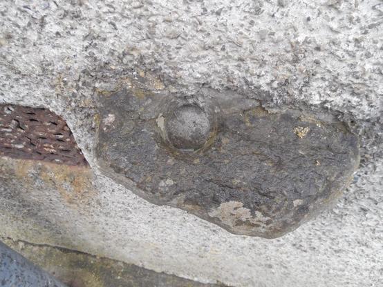
A Different Kind Of Holy Stone
https://fed.brid.gy/r/https://theorkneynews.scot/2026/05/13/a-different-kind-of-holy-stone/
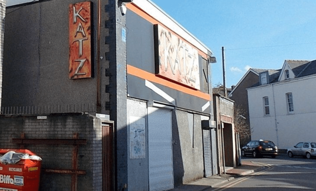
NEATH: Fire damages derelict Katz nightclub — weeks before it was due to go under the hammer again
A derelict Neath nightclub that has been empty for years was damaged by fire in the early hours of Tuesday morning — just weeks before it was due to go back under the hammer at auction.
Crews from Neath, Morriston, Pontardawe and Port Talbot were called to the former Katz nightclub on Queen Street Back Road at 3.11am on Tuesday after fire broke out at the rear of the two-storey building. The blaze affected the first and second floors.
A spokesperson for Mid and West Wales Fire and Rescue Service said: “Crews utilised eight breathing apparatus, three hose reel jets, a 10m ladder, three thermal imaging cameras and small tools to extinguish the fire. The turn table ladder was used to gain access to the building.”
Fire crews left the scene at 6.53am — more than three and a half hours after being called out. A road closure was put in place on Alfred Street and Queen Street Back Road during the incident but has since been lifted.
South Wales Police, who were also in attendance, said the cause of the fire was yet to be determined and is under investigation.
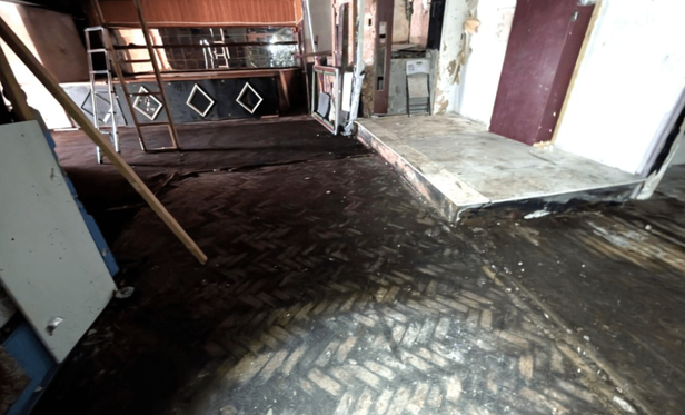
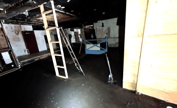
The building has been empty for a number of years since the nightclub closed. For those who remember it, Katz was a fixture of Neath’s night-time economy — a sizeable two-storey venue with a prominent bar, raised stage, and a large dancefloor with original parquet wood flooring that survives inside to this day.
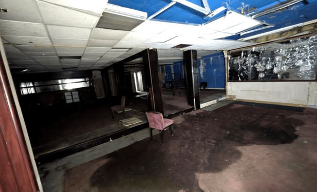
The original parquet dancefloor and the bar with its distinctive diamond-pattern detail, still visible inside the abandoned building (Image: Seel & Co Auctions)One of the first-floor bar areas, with mirrored panels and suspended ceiling still in place (Image: Seel & Co Auctions)The property failed to sell when it went to online auction with a guide price of £145,000 in March. It is currently listed for auction again with a reduced guide price of £85,000, with bidding closing on May 12. The listing describes it as a building “in a state of disrepair” with potential for conversion into flats, a gym, boutique cinema, restaurant or creative studio space, subject to planning permission.
The rear of the building, where Tuesday’s fire is understood to have started (Image: Seel & Co Auctions)The full extent of the damage caused by Tuesday’s fire is not yet known, and it is unclear what impact — if any — it will have on the upcoming auction.
Related stories from Swansea Bay News
Gowerton fire: dramatic scenes at LMS Club on Sterry Road
Our coverage of another significant fire in the area.
Gowerton road remains closed and building assessed for collapse risk after Easter Monday fire
The ongoing aftermath of the Sterry Road fire.
The entrance to a Baroque style former warehouse on Queen Street in Glasgow. Designed by David Barclay, it was originally built for Hunter, Barr and Co. The site on which it was constructed was previously the location of an ornate and imposing branch of the National Bank of Scotland, the first in the city, designed by John Gibson in 1847. Rather than simply demolishing this building, it was moved to the Southside of Glasgow, where it became Langside Halls.
Servitude: the thread about why James Craig’s New Town isn’t as regular as he would have liked
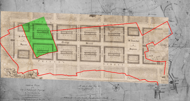
Have you ever wondered why at the far western end of Queen Street, where it meets North Charlotte Street, the regular, right-angled Georgian grid of the First New Town does something odd and has a bevelled corner? You have? Great! Lets find out why that is.
The junction of Queen Street and North Charlotte Street – with the continuation of the block if it followed the grid of the New Town plan in greenNo, the Georgians weren’t future-proofing the street corner here for a 20th century traffic engineer’s filter lane. This has to do with something much more predictable than that – land ownership disputes!
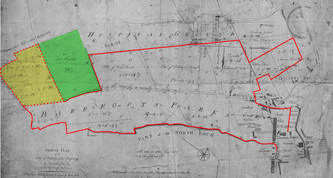
1893 OS Town Plan of Edinburgh, showing the bevelled end to the north western block of the First New Town. Reproduced with the permission of the National Library of ScotlandYou see, when Town Council first had a plan of land ownership drawn up for the planning of the New Town, they didn’t actually yet own all the land on which they intended to build. In fact, they only owned about three quarters of it. Standing in the way to the west was “Allan’s Park“, owned by Dean of Guild Allan (Thomas Allan), and “Barjarg’s Feu” – owned by James Erskine, Lord Barjarg of Drumsheugh House.
John Laurie. Plan of lands for the New Town of Edinburgh, 1766. Allan’s Park is highlighted yellow, with the dashed red boundary, Barjarg’s Feu in green. The land owned by the City is surrounded by the red boundary. Crown copyright, NRS, RHP6080/1Allan’s Park was relatively easy to acquire, and was done so by the time the above plan was released to James Craig and other prospective architects for the design competition in April 1766, but Barjarg’s Feu still formed a salient into it. But planning proceeded on the basis that the Council hoped to acquire the land anyway and James Craig’s winning entry therefore drew the western town blocks over it.
Craig’s winning New Town plan (Copy of 1768 as presented to King George III) overlaid on the above land ownership map of James Laurie. Reproduced with the permission of the National Library of ScotlandBuilding commenced at the eastern end within short order and by the late 1760s or early 1770s, the New Town was creeping westwards. By the time it reached the boundary of Barjarg’s Feu in 1785, in the vicinity of Castle Street, the the owner – by now styled Lord Alva having inherited that estate – agreed to sell to the council and the plan could continue uninterrupted (although it took until 1820 to conclude, and was not on entirely favourable terms for the Cityand subsequent proprietors). But if we look closer at the western edge of Craig’s plan, and compare it with what is on the ground, we notice that Queen Street should meet North Charlotte Street on a regular grid (it doesn’t) and both Queen Street and the city grid should extend for another block west from where it does (it doesn’t!). Something else stood in the way. (P.S. Charlotte Square was originally to be St. George’s Square)
North western end of Craig’s 1768 New Town plan. Reproduced with the permission of the National Library of ScotlandSo what went wrong? Well, it wasn’t just Lord Alva’s land in the way. In 1782, the Trustees of Heriot’s Hospital (who had sold much of the land for the northern portion of the New Town to the city) had sold a portion of land to Francis Stuart, 9th Earl of Moray and on this he had built for himself a mansion, Moray House, and laid out extensive gardens. And Moray wasn’t for selling, so the New Town plans had to be hurriedly altered to build around his land.
Moray House, based on Robert Kirkwood’s 1819 elevation. CC-by-SA 4.0 StephenCDicksonAinslie’s 1804 Town Plan of Edinburgh showing Moray’s land, highlighted in yellow, at the end of Queen Street. Reproduced with the permission of the National Library of ScotlandThis explains why the north western corner could not be completed as planned, and why Queen Street stopped short at North Charlotte Street, but not why they build that awkward and incongruous bevel on the corner? Well that’s because of a little legal thing called “servitude”. What does servitude mean? “A right that an owner of heritable property has over property owned by another. A servitude runs with the land and not the owner“. The Earl of Moray and Lord Alva had servitude over each other that neither could built within 90 feet of their boundary. When Edinburgh bought the land from Alva, Moray maintained his servitude over it. And can you guess what the distance from the bevelled façade on the corner of Queen Street and North Charlotte Street is from the boundary with the Earl of Moray’s land? Yes, that’s right, it’s *exactly* 90 feet.
Ainslie’s 1804 Town Plan of Edinburgh with a measured distance to it from Moray’s land. Reproduced with the permission of the National Library of ScotlandExcerpt from “Block plan of Moray Place” of 1825, showing the boundary of the Moray Feu and how the bevel of the end of Queen Street aligns with it. RHP83734 © Crown copyrightThis old boundary cut through what is now Glenfinlas Street and explains why the pavement suddenly changes width about 1/3 of the way down – it was built at two different times.
Glenfinlas Street, showing the width in pavement change.It wasn’t until the intransigent Earl of Moray’s son began to be feu the ground in 1822 that the owners of the properties on the north side of Charlotte Square got the change to buy the rest of “their” gardens. The maps below show 1817 compared with 1849 (slide to compare). You can see at this time, a garden wall still existed on the old boundary at the very west of these gardens, and that the formal portions (marked out by the perimeter paths) also conform to the boundary.
Comparison of Ainslie’s 1804 Town Plan (l) and 1849 OS Town plan (r). Reproduced with the permission of the National Library of ScotlandYou can find the result of this boundary dispute in other places too. It is the reason for instance that Randolph Lane takes an odd, irregular form if you follow it northwards.
North end of Randolph Lane. The lane is aligned with the Edinburgh grid behind the camera, but follows the alignment of the Moray Feu boundaries beyond it.Amazingly, the last of the legal niceties over this portion of land weren’t resolved along this boundary for almost 170 years! Those nicely cleaned and restored “Georgian” townhouses at 1-3 Glenfinlas Street? They were only built in 1990 to finally finish this corner of the New Town (almost) as planned.
The south portion of Glenfinlas Street – the three “townhouses” built from the cleaner stone date from 1990.There’s actually a few more of these incongruous and awkwardly non-right angles scattered through the New Town – it’s always about old boundaries. This thread details the Gabriel’s Road boundary and the line it still cleaves across the New Town. If you want to understand why any New Town street in Edinburgh isn’t on a right angle – overlay an old land boundary plan on it (in this case, the eastern end of John Laurie’s 1766 plan) and it will probably reveal the answer. Broughton Street and York Lane? Cathedral Lane and the foot of Leith Street? St. James Square and Gabriel’s Road? Truncated southern side of Abercrombie Place? Property boundaries are your answer.
Boundaries highlighted on John Laurie’s 1766 plan (l) overlaid and georeferenced on the modern streets as seen on aerial photograph (r).Note to readers: unfortunately in April 2026, a third-party plug-in more than exceeded its authority and broke many of the image links on this site. No images were lost but I will have to restore them page-by-page, which may take some time. In the meantime please bear with me while I go about rectifying this issue.
If you have found this site useful, informative or amusing then you can help contribute towards its running costs by supporting me on ko-fi. This includes my commitment to keeping it 100% advert and AI free for all time coming, and in helping to find further unusual stories to bring you by acquiring books and paying for research.
Or please do just share this post on social media or amongst friends and like-minded people, sites like this thrive on being shared.
Explore Threadinburgh by map:
Travelers' Map is loading...These threads © 2017-2026, Andy Arthur.
NO AI TRAINING: Any use of the contents of this website to “train” generative artificial intelligence (AI) technologies to generate text is expressly prohibited. The author reserves all rights to license uses of this work for generative AI training and development of machine learning language models.
#Lochend #Logan #Restalrig #StMargaret

Kenneth studied architecture at Glasgow School of Art between 1889 and 1895, which was around the same time as a number of Glasgow's better known architects, including Charles Rennie Mackintosh, James Salmon Junior and John Gaff Gillespie, and from this building, it's clear Kenneth, too, was relatively talented.
Cont./
#glasgow #architecture #glasowhistory #architecturephotography #queenstreet
An 1899 warehouse on Queen Street in central Glasgow. Designed by George S. Kenneth, it bears the crest of the Clan Buchanan, and the monogram C.B., indicating it's a Clan Buchanan Society building, the oldest clan society in the world.
Cont./
#glasgow #architecture #glasowhistory #architecturephotography #queenstreet
Love the grandeur of this building on Queen Street in central Glasgow. Built in the 1910s, it was designed by Thomson and Sandilands in a free style, with Art Nouveau influences and Edwardian Baroque details, that seems to be edging towards Art Deco.
#glasgow #architecture #architecturephotography #queenstreet