Burze i grad pod koniec maja? Taka pogoda na Cyprze może zaskoczyć wielu mieszkańców i turystów. Synoptycy ostrzegają przed niestabilną aurą oraz temperaturami niższymi niż zwykle o tej porze roku. #Cypr #Cypr24 #Pogoda #Burze #Cyprus

https://www.cypr24.eu/burze-wracaja-na-cypr-mozliwy-grad/?utm_source=mastodon&utm_medium=jetpack_social

Burze wracają na Cypr. Możliwy grad

Burze na Cyprze wracają. Meteorolodzy ostrzegają przed ulewami, gradem i chłodniejszą pogodą. Najgorsza sytuacja możliwa w weekend.

Cypr24 – Na Cyprze po polsku

🌩️ PROGNOZA ESTOFEX

Storm Forecast
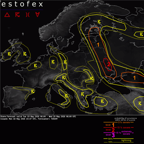
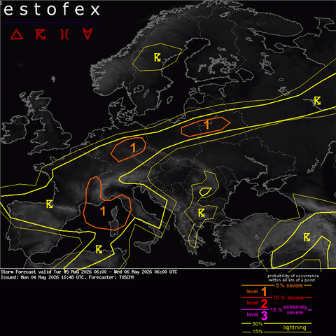
Valid: Tue 19 May 2026 06:00 to Wed 20 May 2026 06:00 UTC
Issued: Mon 18 May 2026 14:37
Forecaster: TUSCHY

A level 2 was issued for parts of the Ukraine mainly for large to very large hail and severe to damaging gusts.A level 1 surrounds the level 2 with similar hazards but lowered probabilities.A level 1 was issued for SE Finland mainly for large to isolated very large hail and strong to severe gusts.A level 1 was issued for parts of SW Russia mainly for large hail and gusts.SYNOPSISA filling trough over CNTRL into SE Europe breaks up into a progressive wave, which crosses the Aegean Sea E and numerous lifting waves over NW Europe. A new digging trough over the NE Atlantic and attendant WAA increase thickness over SW Europe with a building ridge, which amplifies into a new blocking feature for the following days. Blocking persists over NW Russia.The main synoptic-scale boundary of interest is the one, which affects far NW Russia and bends S/SE towards Belarus/Ukraine, spearating an hot and well mixed airmass to the S/E from a more humid and cooler one to the N/W.DISCUSSION...Far E Europe and adjacent areas ...Rising heights/MSLP over W Russia pushes the boundary deeper into the Ukraine whereas a lifting depression over NE Europe causes some eastbound motion over/E of the Baltic States. The inflection point evolves over E-CNTRL Belarus and lifts also N.Constantly improving mass flux convergence over the CNTRL Ukraine and adjacent areas pushes mixed BL moisture in excess of 10-12 g/kg beneath mid-level lapse rates approaching 8K/km. Resulting MUCAPE resides in the 1000-2000 J/kg range with a confined belt of robust CAPE in the 2000-3000 J/kg range next to the boundary itself. Shear improves from E to W and initiating cells pose a large to very large hail risk with 5 cm hail reports (and more) anticipated. DCAPE in excess of 1 kJ/kg also indicates a severe downburst thr...

Pełna treść: https://www.estofex.org/cgi-bin/polygon/showforecast.cgi?text=yes&fcstfile=2026052006_202605181437_2_stormforecast.xml
#estofex #burze

🌩️ PROGNOZA ESTOFEX

Storm Forecast
Valid: Mon 18 May 2026 06:00 to Tue 19 May 2026 06:00 UTC
Issued: Sun 17 May 2026 12:59
Forecaster: TUSCHY

A level 2 was issued for N Belarus into E Latvia for large hail, strong to severe gusts and a few tornadoes. A level 1 surrounds the level 2 with similar hazards including heavy rain.A level 1 was issued for parts of NE Italy mainly for some hail, gusts and an isolated tornado.A level 1 was issued for E-Armenia into Azerbaijan for large hail and gusts.SYNOPSISA negative tilted trough gets entrenched between blocking anticyclones over NW Russia and SW Europe and fractures into numerous confined upper vortices.A NW-ward surging warm front, which evolves into cold/warm fronts next to a structuring depression becomes the main area of concern for DMC activity over NE Europe. DISCUSSION... N Belarus into E Latvia and adjacent regions in W Russia ...A substantial short wave lifts NW into the Baltic States and distorts an accompanying warm front into warm/cold front next to a rather strong 1005-1010 hPa LL vortex, which is well clustered in IFS-ENS data. Strongest CAPE build-up occurs downstream of the wave, as cooling mid-levels overspread a plume with maximized BL moisture near the apex of the distorted front (narrow but well defined warm sector). A meridionally elongated warm sector evolves betimes with a quasi-stationary (shear parallel) cold front and a lifting warm front. This increases residence time of updrafts in the unstable airmass as convection shifts N/NW.A confined overlap of strong CAPE and shear evolves in the highlighted area with only the afternoon hours left for near uncapped/slightly capped conditions. MUCAPE in the 1000-2000 J/kg range and 15/20 m/s 3/6 km shear with strongly looped hodographs highlight a rather volatile environment for organized multicells/supercells. Any cell, riding the warm sector to the NW poses a large hail and severe to damagi...

Pełna treść: https://www.estofex.org/cgi-bin/polygon/showforecast.cgi?text=yes&fcstfile=2026051906_202605171259_2_stormforecast.xml
#estofex #burze

🌩️ PROGNOZA ESTOFEX

Storm Forecast
Valid: Thu 14 May 2026 06:00 to Fri 15 May 2026 06:00 UTC
Issued: Wed 13 May 2026 21:24
Forecaster: PUCIK

A level 2 was issued across N Italy mainly for large to very large hail, severe wind gusts and tornadoesA level 1 was issued across the E Adriatic coastline mainly for heavy rainfall and to a lesser degree for severe wind gusts and tornadoesA level 1 was issued for Sardinia and central Italy mainly for heavy rainfall and to a lesser degree for severe wind gusts and tornadoes.A level 2 was issued for central Turkey for damaging wind gusts and large hail.A level 1 was issued for Turkey mainly for severe wind gusts, heavy rainfall and large hail.A level 1 was issued for southern Russia mainly for large hail.A level 1 was issued for northwestern Russia mainly for heavy rainfall.DISCUSSION... N Italy ... Q-vectors suggest that synoptic-scale lift, associated with an approaching trough, will overspread the area in the late morning to afternoon hours. Towards the surface, a well-defined convergence zone is forecast by all the models to run from the Apennine foothills towards Veneto region. Cyclogenesis is forecast along this zone and mesoscale lift will be provided by either this convergence or local orography. Further cyclogenesis and convergence is anticipated to develop over Lombardy in the late afternoon hours. Airmass around the convergence zones will be characterized by modest low-level moisture with specific humidity between 8 and 10 g/kg and 7 to 7.5 K/km lapse rates, yielding MLCAPE values of 500 to 1000 J/kg. Conditions will deteriorate towards northeast and anywhere south of the Apennnine convergence zone. The first storms will fire on the Apennine convergence zone probably already by 12 UTC. Combination of intense 0-6 km bulk shear up to 30 m/s and 0-3 km shear up to 20 m/s with isolated storm formation will favour supercells. Right-moving supercells will tra...

Pełna treść: https://www.estofex.org/cgi-bin/polygon/showforecast.cgi?text=yes&fcstfile=2026051506_202605132124_2_stormforecast.xml
#estofex #burze

🌩️ PROGNOZA ESTOFEX

Storm Forecast
Valid: Wed 13 May 2026 06:00 to Thu 14 May 2026 06:00 UTC
Issued: Tue 12 May 2026 16:02
Forecaster: TUSCHY

Numerous level 1 areas were issued for S-CNTRL into SE Europe mainly for hail and gusts with a low-end coastal tornado risk over CNTRL/S Italy.A level 1 was issued for parts of Benelux into W-CNTRL Germany for isolated hail and gusts.SYNOPSISWe're in the recharging process of the persistent negative geopotential height anomaly atop N-CNTRL to CNTRL Europe. A new trough approaches from the NW and settels down over CNTRL Europe with a new burst of cool air from the NW. This trough gets framed by blocking anticyclones over the NE Atlantic and N Africa. Another deepening trough affects SE Europe, whereas a quasi-stationary positive tilted trough still impacts the Iberian Peninsula and the offshore areas to the SW.Frontal-wise we still deal with a wavy and slowly eastward shifting boundary over NE into E Europe with more fronts moving in from NW to CNTRL Europe. In addition, geopotential heights/surface pressure lowers over N Italy during the forecast with an evolving diffuse lee vortex. DISCUSSION... CNTRL Italy towards Albania ...Morning convection occurs over far NW Italy and Corse/Sardegna with isolated severe possible (e.g. heavy rain and a coastal tornado event). Rapid weakening during the morning precludes a level 1 upgrade.A passing trough advects cool mid-levels towards the level 1 area, where seasonable moisture from the Mediterranean resides. The net result will be 400-800 J/kg weakly capped MUCAPE with lowering values onshore due to shrinking BL moisture. A confined CAPE/shear overlap exists with long/straight hodographs and up to 15-20 m/s DLS. Organized multicells and a few supercells (e.g. deviating updrafts near the coasts) bring strong to severe gusts and hail in the 2-4 cm range (hail size hampered by thin CAPE profiles and lowered EL heights). An is...

Pełna treść: https://www.estofex.org/cgi-bin/polygon/showforecast.cgi?text=yes&fcstfile=2026051406_202605121602_1_stormforecast.xml
#estofex #burze

🌩️ PROGNOZA ESTOFEX

Storm Forecast
Valid: Tue 12 May 2026 06:00 to Wed 13 May 2026 06:00 UTC
Issued: Mon 11 May 2026 10:53
Forecaster: TUSCHY

A level 2 was issued across parts of SE Romania, Bulgaria into NE Greece and NW Turkey mainly for large to very large hail, severe gusts and regionally enhanced for heavy rain.A level 1 surrounds the level 2 for similar hazards with lowered probabilities. In addition, a regionally enhanced tornado risk exists (e.g. Slovenia/far NE Italy during the morning).A level 1 was issued for NE Spain mainly for hail, gusts and heavy rain.A level 1 was issued for parts of W Russia mainly for hail and gusts.SYNOPSISA blocking anticyclone is placed over the NE North Atlantic/N-Africa and both steer a longwave trough into CNTRL Europe. This through gets sheared apart as jet phasing occurs in its S quadrant and it acquires a negative tilt from E-CNTRL into SE Europe. During the night, a new impulse of low geopotential heights approaches from NW Europe and re-charges another longwave trough over CNTRL Europe for the following days.At lower levels, a wavy boundary runs from NE towards E-CNTRL Europe before bending W towards the N Adriatic Sea. A more diffuse boundary extends towards NE Spain with only marginal S movement betimes. More fronts approach NW Europe during the forecast period but marginal moisture content precludes more substantial thunderstorm activity.DISCUSSION... NE Spain towards the NW Mediterranean ...The passage of a short wave, coupled with cyclonic mid/upper flow and placed in the left exit of a 110 kt H3 jet create a favorable environment for scattered thunderstorms during the forecast. Cooling mid-levels atop modest low-tropospheric moisture assists in 400-800 J/kg MUCAPE onshore, increasing to more than 1 kJ/kg offshore. EFI MUCAPE highlights the offshore areas with anomalous values, whereas EFI CAPE/shear keeps the focus along the coast of NE Spain.Shear/C...

Pełna treść: https://www.estofex.org/cgi-bin/polygon/showforecast.cgi?text=yes&fcstfile=2026051306_202605111053_2_stormforecast.xml
#estofex #burze

🌩️ PROGNOZA ESTOFEX

Storm Forecast
Valid: Mon 11 May 2026 06:00 to Tue 12 May 2026 06:00 UTC
Issued: Sun 10 May 2026 22:58
Forecaster: PUCIK

A level 2 was issued across central part of N Italy mainly for large to very large hail, severe wind gusts and to a lesser extent tornadoes.A level 2 was issued across NE Italy, W Slovenia and Istria mainly for heavy rainfall, tornadoes and to a lesser extent large hail.A level 1 was issued for NW Italy mainly for large to very large hail.A level 1 was issued for SE France mainly for heavy rainfall and large hail.A level 2 was issued for E Croatia, N Bosnia, S Hungary and Serbia mainly for large hail, severe wind gusts and tornadoes.A level 2 was issued for Bulgaria for large hail and severe wind gusts.A level 1 was issued from Croatia to Romania and Bulgaria mainly for large hail and severe wind gusts.A level 1 was issued from Austria through Czechia, central and north Hungary to Slovakia and Poland mainly for heavy rainfall. Tornado threat will be elevated to some degree from NE Slovakia to E Poland.A level 1 was issued across Turkey and Caucasus mainly for large hail and heavy rainfall.A level 1 was issued for central west Russia mainly for heavy rainfall.DISCUSSION... N Italy to Slovenia and Istria ...A short-wave trough is forecast to cross the area during the day with synoptic-scale lift overspreading Piemonte in the late morning hours and shifting to NE Italy and Slovenia by 18 UTC. A cold front, located north of the Alps, is not expected to influence the region. Airmass will be characterized by specific humidity of around 10 g/kg combined with mid-tropospheric lapse rates of 7 to 7.5 K/km. MLCAPE values of 500 to 2000 J/kg are simulated with the highest values over Piemonte and just north of the Apennines. Several mesoscale lift mechanisms will initiate storms during the forecast period. First, the orography is forecast to trigger storms, especially over t...

Pełna treść: https://www.estofex.org/cgi-bin/polygon/showforecast.cgi?text=yes&fcstfile=2026051206_202605102258_2_stormforecast.xml
#estofex #burze

Jako że startuje sezon burzowy zmajstrowałem bota prezentującego prognozy burzowe ESTOFEX
https://mastodon.com.pl/@estofex
#storm #estofex #burze #meteo
ESTOFEX bot (@[email protected])

1 Post, 0 Following, 0 Followers · #storm #forecast

Mastodon Poland

🌩️ PROGNOZA ESTOFEX

Storm Forecast
Valid: Tue 05 May 2026 06:00 to Wed 06 May 2026 06:00 UTC
Issued: Mon 04 May 2026 16:48
Forecaster: TUSCHY

A level 1 was issued for CNTRL/E-Germany mainly for heavy rain. Isolated hail/gusts are possible over E-CNTRL Germany.A level 1 was issued for SE France into the NW Mediterranean and far NW Italy mainly for some hail, gusts and heavy rain.A level 1 was issued for NE Poland into NW Belarus for some hail and a strong to severe gust threat.SYNOPSISWhile strong westerly wave flux persists over Scandinavia, a more blocked and NAO- alike pattern further S offers a quasi-stationary/sheared trough over the Bay of Biscay with another/filling one over far SE Europe. In addition, the trough over SW Europe transitions into another positive tilted trough W of Morocco, with both features creating a broad belt with enhanced W/SW-erlies over parts of SW-into CNTRL Europe.At the surface, an extensive wavy front extends from NW Russia SW towards N-CNTRL Germany, which is embedded within a structuring low pressure channel at the surface. Passing short-waves atop that boundary induce temporal BL responses with weak/transient MSLP minima. IFS-ENS has such a vortex over E-CNTRL Germany, which then shifts NE betimes.DISCUSSION... Germany ...The airmass S of the mentioned boundary offers meager mid-level lapse rates atop a moist airmass, which offers TPWs a bit above the background climatology. This is also seen in a low-end signal within EFI CAPE for E-CNTRL Germany, where mid-level lapse rates steepen somewhat. So we expect MUCAPE maxima over E-CNTRL Germany into NW Czechia with values in the 500 to locally 900 J/kg range.Final shear magnitude resides in the 10-15 m/s range, which is borderline strength for anything organized. However, dependant on the final MSLP geometry, we could see a rather helical SR-inflow with enhanced streamwiseness as BL wind field reacts to the potential/wea...

Pełna treść: https://www.estofex.org/cgi-bin/polygon/showforecast.cgi?text=yes&fcstfile=2026050606_202605041648_1_stormforecast.xml
#estofex #burze

Burze, grad i silny wiatr nad Cyprem! Służby wydały ostrzeżenie, a sytuacja może być groźna. Czy jesteś przygotowany na załamanie pogody? #Cypr #pogoda #burze #alert #Cypr24

https://www.cypr24.eu/zolte-ostrzezenie-pogodowe-burze-uderza-w-cypr/?utm_source=mastodon&utm_medium=jetpack_social

Żółte ostrzeżenie pogodowe. Burze uderzą w Cypr

Żółte ostrzeżenie pogodowe na Cyprze. Burze, grad i silny wiatr mogą powodować podtopienia. Sprawdź prognozę i zagrożenia na najbliższe dni.

Cypr24 – Na Cyprze po polsku