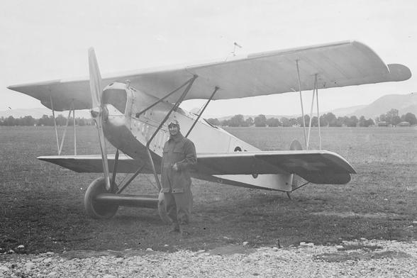
100 years of swisstopo Flight Service: In 1926, #swisstopo pioneered #aerialPhotogrammetry in Switzerland, taking to the skies when aviation was still in its infancy to map the country more precisely and efficiently than ground surveys could. A century later, the #FlightService remains...
https://spatialists.ch/posts/2026/06/07-100-years-of-swisstopo-flight-service/ #GIS #GISchat #geospatial #SwissGIS
100 years of swisstopo Flight Service – Spatialists – geospatial news

In 1926, #swisstopo pioneered #aerialPhotogrammetry in Switzerland, taking to the skies when aviation was still in its infancy to map the country more precisely and efficiently than ground surveys could. A century later, the #FlightService remains the foundation for swisstopo’s geodata and maps and thus an important basis for planning, research, defence, and everyday life.

Spatialists – geospatial news

@runspired.com Use case: People send me planned route on Strava. I want to check hour by hour weather en route (#Komoot), I want to check current snow levels (#MeteoSchweiz), I want to check avalanche risk (#WhiteRisk), I want to check trail closures (#SwissTopo), I want to have it on a phone in an app that has actually useable maps (#Locus).

None of those use-cases can be fulfilled by Strava.

For each of them I need a GPX.

Just noticed that the surroundings of Blatten has been newly measured and published. Most of the hiking trails in the valley have been opened as well. The satellite view still shows the situation from before the disaster.

https://swisstopo.app/poi?lat=46.41972045620123&lon=7.821051449823709

#Blatten #SwissTopo #Map

New OpenRefine Geocoding Extension https://gitlab.com/geometalab/openrefine-geocoding-extension by TihanMo.

The Extension geocodes unformatted addresses to coordinates (Latitude/Longitude) and provides confidence scores using #photon #nominatim and #swisstopo APIs.

Geometa Lab at IFS / OpenRefine Geocoding Extension · GitLab

GitLab.com

GitLab

"The zero coordinate point of the Swiss National Survey LV95"... in Madeira.

A friend having some holidays in Madeira found this: a mark for the 0,0 of the Swiss CRS.
(Well, the zero is on the sea, but not that far ;)

https://www.swissinfopool.com/zero_LV95/

#swisstopo #madeira #switzerland

Some fellow mastodonians suggested I made my altimeter web app work globally. I did.

https://www.thomasweibel.ch/alt/

Now, all you testers out there: Does it work in your location? Is it accurate? Suggestions?

#geography #gis #topography #opendata #ogd #geodata #opensource #openglam #glamhack #digitalhumanities #webdev #webapp #html #javascript #swisstopo @spatialists @OpendataCH @geomob @clolsonus @JensWiesehahn @paulfoerster