Good news: the cool change has reached this part of Melbourne.
Bad news: for many rural parts of Victoria, the Bureau of Meteorology's rain radar is functionally also a bushfire map due to pyrocumulonimbus clouds.

#VictorianBushfires #Pyrocumulonimbus #MelbourneWeather #Melbourne #WeatherToot #Victoria #Australia

Shockingly rapid #bushfire spread and #pyrocumulonimbus development over Big Desert Wilderness Park, northwest Victoria, Australia today. Ongoing!

#GrandCanyon, #Utah #wildfires creating "#FireClouds" that can form their own weather systems

August 1, 2025

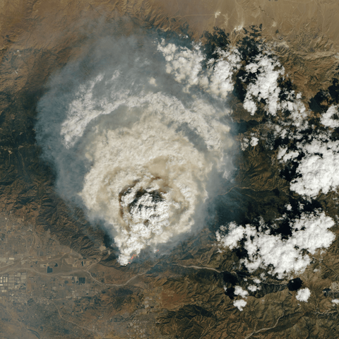
"Two wildfires burning in the western United States — including one that has become a '#megafire' on the North Rim of the Grand Canyon — are so hot that they're spurring the formation of 'fire clouds' that can create their own #ErraticWeather systems.

"In #Arizona, the wind-whipped #DragonBravoFire that destroyed the #GrandCanyonLodge is 9% contained and has charred more than 164 square miles to become the largest fire now burning in the continental U.S. and one of the top 10 largest in recorded Arizona history. Getting around it would be roughly like driving from New York City to Washington, D.C.

"Another large fire in #MonroeUT, has burned 75 square miles since July 13 and is 11% contained, officials said Thursday. Evacuation orders were issued Wednesday for several towns in the fire's path, and scorched power poles prompted the shutoff of electricity in other nearby communities in south-central #Utah.

"Utah Gov. Spencer Cox declared an emergency Thursday as #wildfires grew around the state and planned to visit Monroe on Friday.

"Towering convection clouds known as #pyrocumulus clouds have been spotted over Arizona's blaze for seven consecutive days, fueling the fire with dry, powerful winds, fire information officer Lisa Jennings said. They form when air over the fire becomes #superheated and rises in a large smoke column. The giant billowing clouds can be seen for hundreds of miles and can resemble an anvil.

"Their more treacherous big brother, a fire-fueled thunderstorm known as the #pyrocumulonimbus cloud, sent rapid winds shooting in all directions this week as a smoke column formed from the Utah fire then collapsed on itself, fire team information officer Jess Clark said.

" 'If they get high enough, they can also create #downdrafts, and that's something we really watch out for because that can quickly spread the fire and can be very dangerous for firefighters who are doing their work on the ground,' Jennings said.

"Multiple fire crews in Utah were forced to retreat Wednesday as the unpredictable climate created by the clouds threatened their safety, officials said. Fire crews in both Utah and Arizona had better control of the blazes, but containment has been slipping as the fires grow rapidly.

"The same type of cloud, which the National Aeronautics and Space Administration has dubbed the 'fire-breathing dragon of clouds,' recently formed a fire tornado that tore through an eastern Utah neighborhood with wind speeds estimated at 122 miles per hour."

Read more:
https://www.cbsnews.com/news/grand-canyon-utah-wildfires-creating-fire-clouds-that-can-form-their-own-weather-systems/?utm_source=firefox-newtab-en-us

#Firenado #ExtremeWeather #WildfireWeather #ClimateChange #GlobalBurning #USWx #ExtremeWx
#Utah #GrandCanyon

Grand Canyon, Utah wildfires creating "fire clouds" that can form their own weather systems

Wildfires burning at the Grand Canyon and in Utah are so hot that they're spurring the formation of "fire clouds" that can create their own erratic weather systems.

Today we take a look at the #wildfires in Alberta, Canada and check some dramatic #pyrocumulonimbus activity visible from satellites https://youtu.be/VvyKE_VglSY
Canada wildfires and pyrocumulonumbus - satellite look

YouTube

The intense heat from wildfires fuels updrafts, lifting smoke and vapor into the atmosphere. As the plume rises, water vapor cools and condenses around particles (including ash particles) to form cloud droplets. Eventually, that creates the billowing clouds we see atop the smoke. These pyrocumulus clouds, like this one over California’s Line fire in early September 2024, can develop further into full thunderstorms, known in this case as pyrocumulonimbus. The storm from this cloud included rain, strong winds, lightning, and hail. Unfortunately, storms like these can generate thousands of lightning strikes, feeding into the wildfire rather than countering it. (Image credit: L. Dauphin; via NASA Earth Observatory)

https://fyfluiddynamics.com/2024/10/when-fires-make-rain/

#cloudFormation #convection #fluidDynamics #physics #pyrocumulonimbus #pyrocumulus #science #thunderstorm #turbulence #updrafts #wildfire

Weather-Making Fire Burns in Southern California

Intense blazes, including the Line fire, supercharged afternoon convective clouds.

@LuckyetVous
Aussi je suis tombé sur cet article, ça parle de #pyrocumulonimbus du aux incendies géants.
https://www.nationalgeographic.fr/environnement/2021/08/comment-la-fumee-des-feux-de-foret-refroidit-elle-notre-planete

Je me dit aussi que vu l'ampleur et les durées de ces feux ça risque de changer la température de surface des océans sous ces panaches non ? et quels effets avec #lanina qui se prépare ?

Comment la fumée des feux de forêt refroidit-elle notre planète ?

Alors que la saison des incendies s’intensifie, les scientifiques se penchent sur l’un des impacts paradoxaux de la fumée des feux de forêt : le refroidissement, parfois mondial, de notre Terre.

National Geographic

In #Südkalifornien führte ein #Waldbrand am 9. September 2024 zur Bildung eines #Pyrocumulus, einer "#Feuerwolke", die später zu einem #Pyrocumulonimbus-Gewitter heranwuchs. Diese Wolken entstehen durch starke #Hitze und #Rauch von Waldbränden, die #Wasserdampf aufsteigen lassen. Evakuierungen wurden in mehreren Gemeinden angeordnet.

#LineFire #Waldbrand #Evakuierung #Klimawandel #Trockenheit #Dütte #GlobaleErwärmung

https://earthobservatory.nasa.gov/images/153300/weather-making-fire-burns-in-southern-california

Weather-Making Fire Burns in Southern California

Intense blazes, including the Line fire, supercharged afternoon convective clouds.

#LineFire has “room to grow now in essentially 3 directions & there are population centers & pretty dense, dry vegetation in between those population centers,” UCLA #climate scientist Daniel Swain said.

The fire sparked Thurs & burned ~3,800 acres by Sat AM, before ballooning thousands of acres through the afternoon. The blaze was so intense that it also formed a towering #pyrocumulonimbus cloud —a fire-generated thunderstorm— that was sending out its own lightning, erratic winds & brief rain.

Das Park Fire in #Kalifornien hat bereits 600 Quadratmeilen verbrannt und erzeugt gefährliche #Pyrocumulonimbus-Wolken (pyroCb). Diese #Rauchgewitterwolken können #Blitze erzeugen, die weitere Brände entfachen. PyroCbs entstehen durch intensive #Hitze und trockenen #Brennstoff und verstärken die #Feuer. #Klimawandel begünstigt ihre Entstehung, und sie beeinflussen das Wetter sowie globale Temperaturen durch die Absorption von #Sonnenlicht.

#ParkFire #Wildfire #PyroCb

https://grist.org/science/california-park-fire-spawning-smoke-thunderclouds-pyrocumulonimbus/

California’s Park Fire is spawning its own smoke thunderclouds

The wildfire has generated so much smoke and heat that it’s creating one of the strangest natural phenomena on the planet.

Grist
#Pyrocumulonimbus🔥⛈️ downwind of large wildfire on 14 Nov about 70 km NW of Miranda, Mato Grosso do Sul, Brazil🇧🇷 fire heat signatures and lightning, tilted 90 degrees. #pyrocumulus