Big Chico Creek looking big this morning after a night of heavy #rain. I reckon it’ll get more swole as the day goes on. Lots of silt and ash still washing down from the #ParkFire burn scar.

#CAwx #ChicoCA

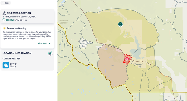
Modified (downgraded) evacuations for the Park Fire in Mono County. as of 11/16/25 11:28PT

"...An evacuation warning is now in place for your zone. You may return home but remain alert to warnings and be ready to evacuate should conditions change. Hwy 395 is open with escorts. ready.mono.ca.gov ..."

#ParkFire #wildfires #CAwx #evacuations

https://protect.genasys.com/location?z=10.181240264413825&latlon=37.59887791356506%2C-118.76165359876745

@MsMerope Lol #ParkFire burn scar threhold is 0.6 inches per hour for debris flow... Check out that forecast!
It’s The Wind Stupid

The effect of wind is seen in this photo from the 1988 Yellowstone fires. The charred trees marks the main direction of the fire as well as “spotting” showing how wind can advance a fir…

The Wildlife News
GISsurfer General Purpose Web Map and GIS Viewer | Surf GIS DATA

GISsurfer lets you surf a nearly endless amount of GIS data. Click a layer in the GIS server's table of contents and that data appears on the map.

Scenes from Oroville, CA
Firefighters staying at the hotel where I stayed in Oroville on 8/15/24. They were fighting the Park Fire, an arson caused fire that started on 7/24/24 and to date has burned 429,603 acres, the fourth largest in recorded California history. The trucks are from San Bernardino County Fire Department. #ParkFire #wildfire #handcrew #firefighters #SanBernadino #Oroville #ButteCounty #firetrucks #California

#CAwx #WAwx

Morning Status of fires followed by BakersRelay. Note: info may be several hours old.

#BoiseFire ACRES: 12,907 CONTAINMENT: 46%
#CoffeePotFire ACRES: 5,044 CONTAINMENT: 0%
#PioneerFire ACRES: 38,735 CONTAINMENT: 23%
#TenajaFire ACRES: 130 CONTAINMENT: 50%

Fires no longer relayed by BakersRelay except for community communications.

#ParkFire ACRES; 429,603 CONTAINMENT: 92%