Rails to Trails: the thread about how North Edinburgh got its cycle paths

On this day (June 1st) 40 years ago, to the tune of the pipes, a councillor cut the ceremonial ribbon and opened a section of cycle path in the north of Edinburgh. This was a rather special bit of cycle path; it was the result of direct action. Over the course of a single week it had been reclaimed from the trackbed of an old railway by a group of spade-wielding and wheelbarrow-pushing volunteers. Wind the clock forward four decades and from these humble beginnings has grown a network of almost 20km (12 miles) of such paths in this part of the city. The credit for this sits almost entirely with the relentless (and often thankless) hard work of a single, slightly anarchic organisation. This thread is the story of how the North Edinburgh Path Network came to be.

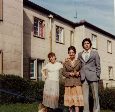
If the council won’t build your cycle path, build your own! Spokes volunteers of all ages hard at work on the Pilton Path in May 1986. Credit, Chris Hill via Spokes

Railways arrived in Edinburgh in 1831 with the Edinburgh & Dalkeith Railway (better known as “The Innocent”) which approached a terminus at St. Leonard’s from the south. In the following decade four other lines converged on the city from the points of the compass. In 1842 the Edinburgh & Glasgow arrived from the west as far as Haymarket and the first section of the Edinburgh, Leith & Newhaven approached from the north to link the city with the Forth ports and from there north to Fife. In 1846 the North British blasted its way through Calton Hill from the east and in 1848 the Caledonian arrived at Princes Street from the southwest. These last two companies came to dominance, the NB in particular on the east coast. Over the next fifty or so years they fought a protracted and at times exceedingly bitter war with each other for traffic, routes and rights of access and Edinburgh was just one of the battlefields of this war. In particular each sought to corner the lucrative dock and industrial traffic of Leith and Granton, sprouting a tangled web of rival lines and counter-lines as they vied for supremacy.

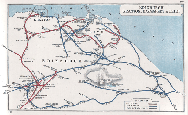
1905 Railway Clearing House diagram showing the competing Caledonian (red) and North British (blue) lines snaking their way around and through the city.

Most of these lines offered passenger services but many proved to be marginally profitable from the outset and as a result stations began to be closed as early as 1905. Wartime economies in 1917 saw further closures; some were temporary but others such as Powderhall were for good. These continued during the lean economic years of the 1920s. A few new suburban halts were built as the city began to sprawl outwards in the 1930s but in the years following WW2 closures began again. Most lines remained busy with freight traffic at this time but by the dawn of the ‘Sixties, the times were a-changin’. Shifting government priorities, industrial decline and the move of passengers from rails to the roads precipitated a rapid run-down and closure of nearly all the railways in the north of the city.

This left many miles of disused railway infrastructure in the north of the city, which for generations of local government and Scottish Office planners offered an irresistible blank canvas on which to build new roads. Much of it therefore found itself reserved in strategic plans for schemes such as the Western Approach Road or the Ferry Road Relief Road. Edinburgh Corporation and its successors began to acquire the land for this purpose. It is therefore ironic that it was this car-brained official thinking that would preserve these routes from other development until an alternative use presented itself.

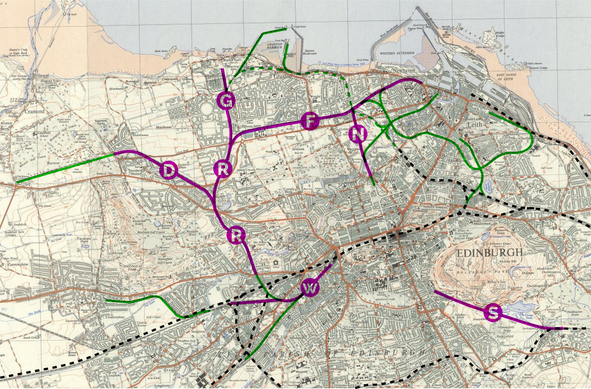
Abandoned railway trackbeds in Edinburgh in the early 1980s. The purple lines were those reserved as road corridors in strategic plans (W = Western Approach Road, R = Roseburn to Ferry Road Link Road, D = Davidsons Mains Bypass, G = Granton Spur, F = Ferry Road Relief Road or West Approach Road to Leith, N = Northern Spur, S = St Leonard’s Spur). The dashed green sections remained nominally open for rail traffic until 1984. The black, dashed lines are routes that remained open. Base map 1:25,000 OS map, 1959, reproduced with the permission of the National Library of Scotland

One such alternative use was first mooted way back in 1968 when Colinton Amenity Association approached both Edinburgh and Midlothian with a view to acquiring the abandoned Balerno Branch railway for conversion into a “unique walkway” along the Water of Leith. This would ultimately become part of the Water of Leith Walkway. The first such railway path – the term then in vogue for such schemes – in Scotland was an 860 yard route opened at Victoria Park in Glasgow in June 1970. Neither of these schemes were cycling routes however. The first planned from the outset as such in the UK was the High Peak Trail in Derbyshire, which began in 1971. In Edinburgh it was 1975 when such a proposal was first made as part of a £90m local development and regeneration plan for Leith. This referred to the formation of “footpath[s] and cycleway[s]” on former railway lines, suggesting routes between Warriston and Coburg Street and from Pilrig to Seafield.

Cover, City of Edinburgh, Leith Local Plan, Draft Final Report, April 1975. Volume Two. Schedules and Appendices.

The Leith Local Plan was published at a time of great change in Scottish local government. That year the old unitary authority of the Corporation of the City of Edinburgh was abolished (along with all the old burgh, town and county councils in the country) to be replaced by a two tier system – Edinburgh District Council and Lothian Regional Council. While the Region had transport within its remit (thus, in theory, cycle paths) the District was responsible for recreation and regeneration and therefore also had them within its remit.

Lothian Regional Council ghost sign on the former Leith Tramway Depot, 20 plus years after that authority ceased to be. Photo © Self

In 1977 Lothian Region published its first transport strategy in its inaugural Structural Plan. Detailed in its many pages there were multiple major road schemes but not a single mention of cycling. This mobilised members of Friends of the Earth in Edinburgh who formed SPOKES, the Lothian Cycle Campaign that year specifically to represent against the plan and to lobby in upcoming council elections.

To ensure that council policies actively encourage cycling and make full provision for it, as part of an overall strategy through which all members of the public can enjoy cheap, safe and efficient travel for work and leisure

The second of Spokes’ two founding objectives, from Spokes Newsletter no. 1, early 1978

The campaign group got off to a good start with the unlikely assistance of Conservative District Councillor Ralph Brereton. His irate letter to The Scotsman about their campaign to permit cycling across the Meadows provoked an unintended backlash that garnered significant free publicity and support for his intended target:

Parks are for quiet, decent people. SPOKES can get lost and take its Commie friends with it. Who wants a proletarian dictatorship anyway? Not me, and not Marchmont.

Ralph Brereton, “Conservative Councillor for Marchmont, and proud of it”. The Scotsman, May 8th 1978

In 1979 further campaign pressure was applied on the Region by the Scottish Association for Public Transport who recommended turning old railways in Edinburgh into cycle paths where there was not the money to turn them into a metro or tram system. This lobbying proved effective and in December 1979 council officials were instructed to investigate further. In 1980 a price of £305,000 was agreed with British Rail for former railways to Granton and North Leith (marked G and L in red on the map below). The overlapping remits of the two authority tiers for implementing cycle paths might have found them either either working in isolation or at cross purposes. But with remarkable foresight, Spokes had used the Structure Plan consultation to insert a policy on cycling that obliged the Region and District to co-operate in this area.

Principal abandoned (or soon to be abandoned) railway trackbeds in Edinburgh in the early 1980s, not including industrial or dock lines; blue lines are former North British Railway, red the Caledonian Railway. The letters correspond to the line and branch names in the table at the bottom of the page. The black, dashed lines are routes that remained open. Base map 1:25,000 OS map, 1959, reproduced with the permission of the National Library of Scotland

The District therefore separately began acquiring former railway routes in North Leith (marked N in blue on above map) and also between Easter Road and Seafield (marked W in red). This was financed by the Scottish Development Agency (SDA) which had jointly inherited the 1975 Leith Local Plan and its cycle path proposals. The SDA had actually been trying to get this land off of British Rail since 1976 but had found itself in the “ludicrous situation” of two public bodies squabbling amongst themselves over something of relatively inconsequential financial value. The SDA wanted a quick and cheap sale of the land valued as derelict, BR was holding out for the higher price it could get for industrial development sites.

With the two council tiers now dipping their toes deeper into path schemes, Spokes saw the opportunity to coordinate their efforts towards a coherent, contiguous, off-road cycling network for the north of the city. To this end in January 1981 they published the report Rails to Trails, which detailed a vision to “provide safe and convenient commuter links between the northern suburbs and the city centre“. This was the genesis of what would become the North Edinburgh Path Network (NEPN). Although its focus was obviously on cycling it was made clear from the outset that nothing should “conflict with the needs of pedestrians using the routes“.

Maps of former railways in North Edinburgh in the “Rails to Trails” report by Carol Crawford, published by Spokes, January 1981

In May 1981 the Secretary of State for Scotland, George Younger, gave Lothian Region permission to set aside £610,000 over five years to convert its railway trackbeds in Edinburgh into paths for cycling and walking. They also sought permission to formally abandon the road schemes planned for these same lines but the Secretary of State refused to allow them to be removed from the Structure Plan. A threat thus hung over these paths before they were even begun that they might find themselves turned into roads. On July 6th that year the Region formally adopted its cycling policy statement, one which was remarkably similar to the second of Spokes ‘ founding objectives!

It is the policy of the Regional Council to allow greater freedom of movement to pedestrians or and cyclists and to encourage more people to walk and cycle for work and leisure journeys (Structure Plan – paragraphs 76 and 13l4(a)).

Lothian Regional Council circular from the Director of Highways P. J. Mason, 1981

In October the Region put its proposals – which looked awfully similar to those sketched out by Spokes in Rails to Trails – out to public consultation. The race was now set between them and the District to complete Edinburgh’s first railway cycle path. The latter won, just, and on June 15th 1982 the mile and a half route between Warriston Crescent and Couper Street in Leith was opened by Lord Provost Tom Morgan. It had cost £250,000, a significant amount of money on account of the retaining wall of the river bank and four bridges needing to be repaired. John McCracken of the SDA handed the route over to the city and said it would “make a significant contribution to the agency’s environmental improvement programme which is rapidly transforming Leith“. A further £110,000 was spent on landscaping the old coal yard at Junction Bridge into the Coalie Park area and in the November the project was awarded a Civic Trust Awards commendation.

Coalie Park area and the new path in 1982. The housing of The Quilts is yet to be built on the derelict industrial land on the south (left) bank of the river here. Photo via Water of Leith Conservation Trust

From the outset this new route was part of the nascent Water of Leith Walkway and was signed as such. At this time it was strictly speaking two separate paths, the railway between Powderhall and Granton was still in active use and cut it in half at the Bonnington Level Crossing. This resulted in a detour through the allotments at Warriston, beneath the active line. As a result each half of the path got a separate name; from Coalie Park to the level crossing it is the Water of Leith Path and further west it becomes the Warriston Path. Initially the surface was compressed whindust and cycling was only officially “tolerated” at policy level rather than formally recognised by signage. In 1984 Spokes took the authorities to task over this ambiguity after one of its members was stopped by the police for daring to cycle here. Since then blue permission signs have appeared along these and other paths to this effect.

Coalie Park opening plaque at the entrance to the path from Coburg Street. Edinburgh and Scottish Collection, Edinburgh City Libraries

Lothian Region were not far behind and the first section of their Innocent Path in the southeast of the city opened on 11th August 1982, running about a mile between Duddingston Road West and the Wells o’ Wearie. Here it terminated at the entrance to the Innocent Tunnel which remained closed at this time. Again the surface was compressed whindust, making it suitable for use as a bridleway but rather useless for cycling in the winter, and as it was felt to be a rural setting no street lighting was provided. Information boards on the history of the railway here were provided, this is something has been widely repeated for other railway paths in the city. The £40,000 project budget included £27,000 provided as labour by the Manpower Services Commission (MSC).

The original 1982 information board for the Innocent Railway path

The ribbon was cut by Lynda Chalker MP, Under-Secretary of State for the Department of Transport. Spokes attended this ceremony “in force” to “confront the Minister” over the fact that Government policy towards cycling in Scotland was lagging far behind England and Wales. They charged that there were no central studies for turning disused railways into paths, the Scottish Office had no technical or policy documents in this area, had no cycling officer and made no grants available to Councils for cycling schemes. After a consultation in 1985 on options to extend this route into the city far as St Leonard’s work commenced in 1987 to refurbish the tunnel and it was reopened in 1989.

Dave de Feu of Spokes, right, forms part of the welcoming committee for Lynda Chalker at the opening of the Innocent Path. On the left, adjusting his tie, is Conservative Councillor Ian Cramond, Convenor of Lothian Region’s Transportation Committee at that time. Credit, Chris Hill via Spokes

The Innocent however can not be considered part of the North Edinburgh routes and it was September 1982 when the Region approved the laying of a whindust surface and adding street lighting for its two lines that forked north from Craigleith to Davidsons Mains and to Crewe Toll. The former section was opened on 21st November 1983 by Tony Gaffney of the Institute of Civil Engineers having cost £63,000, three quarters of it as labour provided by the MSC. The section to Crewe Toll followed the next year, as did work on the former Corstorphine branch from Balgreen. At this time Liberal councillor and Spokes member (the late) Donald Gorrie was able to push for the adoption of a 3 metre-wide tarmac surface as a standard for future work. This was best practice developed by the forerunner of Sustrans for the Bristol & Bath Railway Path, on which they had been working since 1979.

https://www.flickr.com/photos/127340508@N05/15255410973/

The District at this time began work on their path from Quarryholes on Easter Road to Seafield and Leith Links. They specified this as a “trim track“, with numerous pieces of wooden exercise equipment added along the route. The original 1975 plans connected this route all the way to Pilrig Park but the bridges that carried it across Easter Road and Leith Walk had been demolished in 1980. The Restalrig Railway Path has therefore always been somewhat cut off from the rest of the railway path network. Its surface was the usual whindust, seasonally impassable, it had no street lighting and most of its access points were narrow steps. This was a situation not improved upon until 2009.

https://www.flickr.com/photos/beqi/3282799986/

Meanwhile back in North Leith, the District Council and the SDA had been infilling the railway cutting that ran through Victoria Park and between Gosford Place and Connaught Place. As this work approached its conclusion a path was approved to connect with the new path along the Water of Leith. This scheme was adopted by the Leith Boys’ Brigade to mark their centenary in 1983 and they raised £1,000 towards the cost of the landscaping of this section. It would be named Stedfastgate in their honour (from the traditional spelling of their motto of Sure & Stedfast) when it was opened on October 8th 1983.

Plaque commemorating the opening of the Stedfastgate section in 1983. CC-by-SA 4.0 Mike Shaw via Wikimedia

In 1983 the Scottish Office, after continuous pressure from Spokes, started to play catch-up with what was happening in England. They commissioned a national feasibility study on re-opening old railway lines as cycle routes – the Scottish Railway Path and Cycle Route Project – led by John Grimshaw of Bristol-based Cyclebag (the direct predecessor of Sustrans, now the Walk Wheel Cycle Trust). Again the MSC provided the labour for this project; ten unemployed professionals were engaged as surveyors and draughtsmen and their tasking included photographing every disused railway bridge in the country! At the same time Grimshaw was also contracted by Lothian Region to undertake a similar exercise within their territory. The reports for both of these projects would be published in 1985 and would propose more than 800 kilometres of routes, 250km of which were in Edinburgh and the Lothians.

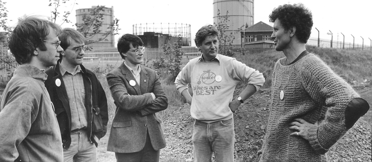
Discussing Spokes’ Pilton Path project in 1986. From left to right, Dave de Feu of Spokes; Labour councillor Donald Anderson and MEP David Martin; Ewen Jeffrey of Spokes and John Grimshaw of Cyclebag / Sustrans. Photo Credit: Chris Hill

1986 proved to be a very productive year for the path network in the north of the city. The Region had been pressing on with its projects and these were now coming to fruition. An extending of the path south from Craigleith, begun in 1984, was opened by Councillor Tom Ponton on May 5th as far as the former Murrayfield Station. The District Council contributed £14,000 in labour by youths on their Special Measures Programme. The viaduct over the Water of Leith here caused problems at first, with objects being thrown from it onto houses and parked cars below. Metal barriers were installed along the parapets but a proposal by local residents to completely enclose the bridge in a wire cage was rejected. Soon afterwards the section east from Crewe Toll to the former Granton Road station also opened. The latter site proved something of an obstacle to future progress however as the trackbed had become heavily flooded and turned into something of a quagmire.

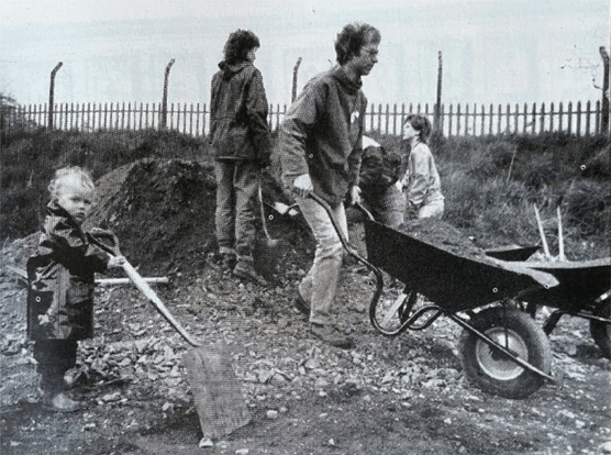
Spokes was not however content with the pace of change and decided to take matters directly into their own hands. In March 1986 they publicly announced a project to mark European Road Safety Year – they would clear and resurface a mile-long section of path north of Crewe Toll all by themselves. They gave themselves just seven days to complete this ambitious scheme, coinciding with National Bike Week from May 24th to 31st. Around fifty enthusiastic volunteers signed up to work under the supervision of John Grimshaw. Lothian Region provided a mechanical grader to strip the surface and 1,000 tons of hardcore and 250 tons of whindust dressing were laid, much of it moved by hand. These materials had been paid for by the Region who had also arranged the lease on the land from British Rail and committed to laying a tarmac surface and installing lighting within three years. Pupils from nearby St David’s R.C. Primary School helped to plant trees along the route with the Lord Provost.

Harry Henniker of Spokes on the overgrown trackbed that would become the Pilton Path just before work started, May 1986. Beneath the bridge that carried West Granton Road over the tracks.

Work was completed in time for the planned opening on June 1st and the ribbon was cut by Councillor Ron Muir, Vice-Chair of Lothian’s Transportation Committee, to the accompaniment of the Nor’ Loch Highland Pipe Band. However it very nearly didn’t happen: an administrative disaster almost befell the project at the 11th hour when council lawyers decide it required the same legal consent as a road project but that they were much too busy to deal with it. It took crucial inside assistance from long-time supporter Councillor Donald Gorrie for the necessary paperwork to be rushed through and the statutory neighbour notifications were delivered by bicycle in the nick of time. Completion of this route was seen as a missing link connecting the paths to the Silverknowes Promenade, a cycling ban on which had been lifted in 1985 after lobbying by Spokes.

Opening of the Pilton Path, June 1st 1986. Councillor Ron Muir, Lothian Region’s vice chair of the Transport Committee officiates, the Nor’ Loch Pipe Band ready to lead an inaugural procession. Various members of Spokes and some local councillors stand on the embankment beyond. Photo Credit: Chris Hill

That same May the Labour Party won a resounding victory in elections for Lothian Region and took majority control. One of the first actions of its new Transport Chairman – the late Alistair Darling – was to fulfil an election promise and cancel the Western Relief Road. On May 21st, just days before Spokes started work on the Pilton Path, a special meeting voted to cancel that multi-million pound road scheme once and for all. This finally removed the threat it had posed to a number of sections of recently laid railway paths. (Incidentally, the Roseburn Corridor has always remained reserved in planning as a potential public transport corridor and it was not until February 2024 where its status as an active travel path was also so affirmed.) The year was rounded off with a final victory for Spokes when both council tiers agreed in October to throw out a housing development proposed by Safeway behind their supermarket at Davidson’s Mains and to safeguard the railway trackbed there as a path (which was eventually surfaced with tarmac within the last few years).

An early Spokes rally in Holyrood Park in 1979; member Canon Bill Brockie of St Martin’s Church in Dalry addresses the crowd. The man left of centre back with his arms folded is the late Alistair Darling. Credit, Chris Hill

1986 was also the year that the final sections of abandoned tracks were lifted on the railways north of Powderhall; the last regular trains having run to an oil depot at Granton along the Lower Granton Road embankment in 1984. This delay in lifting the tracks had a knock-on effect on the timescale for the acquisition of the trackbed here by Lothian Region, something that would not complete until 1989.

https://flickr.com/photos/117983829@N03/13893423695/in/album-72157643950735923

While the growth of the path network in the north of the city had progressed reasonably well, Spokes remained critical of the Regional Council’s ability to deliver such projects in a consistent manner. This was due to a lack of dedicated resource they estimated up to £400k per annum, almost three quarters of the available budgets, was going unspent as a result. To remedy this, in 1987 another Labour Party manifesto commitment that Spokes had campaigned for was enacted and the authority’s Highways Department established a dedicated, three-member cycle team. This was headed by Richard Williams and with an annual budget of £300k maintained a centre of focus and knowledge within the labyrinthine, roads-focussed organisation. This team would prove remarkably adept at also making use of the underspends in other parts of the organisation at the end of the financial year; there was always tarmac to be laid somewhere.

Lothian Region’s dedicated cycling team. On the left is Matthew Simpson, centre is Rory Summerling and on the right is Richard Williams. This team found itself constantly under threat of disbandment due to cost-cutting, but survived through to April Fools’ 1996 when the Region was abolished and the City of Edinburgh Council came into being, a loss of expertise long lamented by Spokes. Credit, Spokes.org.uk

Come 1988 and there were now six sections of railway paths and the Region’s councillors sat down to agree on what to call them. It was decided they should be named after the neighbourhoods through which they ran and that they should no longer be called railway paths. Just paths was fine, Councillors Neil Lindsay and Donald Gorrie had felt the established practice was “daft” and so for instance the path between Roseburn and Craigleith became the Roseburn Path, etc. These remain the official names as adopted by Edinburgh Council in their statutory list of roads and paths. A fuller list of the various path names and their chronology can be found in Table 1 at the foot of this post.

Warriston Path signage. The red 75 marker refers to the National Cycle Network route. Photo © Self

The paths network in the north of Edinburgh city continued to grow in 1988. At Roseburn, the bridge over busy Roseburn Terrace was refurbished and the path extended south across it to a new access point down the embankment at Russell Road. £64,000 was also spent to improve walking and cycling routes around Trinity Academy, there having been a dozen road accidents in just 3 years involving its pupils. This resulted in the path through Victoria Park to Stedfastgate being improved and also in a westward extension from there towards the quagmire at Granton Road. A major issue began to impact cycling paths projects across the UK that year however when the MSC’s Community Programme was abolished by the Government. The sudden loss of access to funded labour precipitated a national crisis in the voluntary sector that had grown up around this resource.

“Fiveways Junction” c. 1995, showing the incomplete path branches leading south and the fingerprints of Lothian Regional Council’s Highways Department all over the painted road-style markings. To the top right the people are walking towards Granton Road Station, to the left is the route to Victoria Park and Trinity Academy. Bottom right leads to the Trinity Tunnel and the two incomplete forks are the beginnings of the Chancelot and the Goldenacre Paths south. Photo Credit: Chris Hill

In 1989 Lothian Region and Lothian Health Board published a booklet of sixteen runs and cycles across the city as part of a healthy living campaign. The Evening News commissioned Richard Peploe, Scottish 12 hour Mountain Bike champion, to ride one of these and report back. Richard cycled from Roseburn to Trinity and his observations give us an insight into what the paths were like to use almost thirty years ago – and to compare with how they are now. He commended the gentle gradients and segregation from traffic, but criticised that access was “through a jungle of metal” (at this time the access points had obstructive barriers designed to stop motorbikes; sometimes laid directly across the paths themselves), the graffiti, “bags of rubbish and abandoned sofas” and an “enormous amount of broken glass“.

You come across all types of people: families out on bikes, young lovers out for a stroll, a group of teenagers, people walking their dogs. And dogs. Lots of dogs – and lots of dog dirt.

Users of the Roseburn Path, described by Richard Peploe. Edinburgh Evening News, 29th July 1989

Peploe noted that the tarmac of his route ran east as far as Granton Road, beyond which it was passable by bike “only with great difficulty“. He finished with a call to the newspaper’s readership to go and explore the paths for themselves:

If you live anywhere near one of the many access points to the paths, you may have seen the blue and white signpost. Go and investigate them one day, and you will see parts of Edinburgh you’ve never seen before!

Users of the Roseburn Path, described by Richard Peploe. Edinburgh Evening News, 29th July 1989

It was not just the benefits of paths to human health that were being recognised. That same year a study by Lothian Region highlighted the biodiversity value of the wildlife that had made its home along the embankments. In 1990 a management scheme and annual budget was approved to fund volunteer groups to help maintain and improve this habitat.

Come 1991 Sustrans’ engineer in Scotland, Dave Holladay, told the Scotsman that “Lothian stands out in front of the whole of the UK“. There were by this time a total of thirty miles of railway paths across the region, although much of this was outwith Edinburgh. A survey that year found 100 cyclists a day were using the path between Craigleith and Crewe Toll, half during commuter rush-hour. In an effort to better publicise the growing network in October that year Spokes published the second, improved edition of their cycling map of the city. These maps continue to be updated and published to this day and have become an exemplar standard of the genre.

The cover of the first edition of the Spokes cycling map of Edinburgh published in 1987. Credit, Spokes.org.uk

Completion of the section between the “impassible” quagmire at Granton Road Station through to Victoria Park that Peploe had commented upon had been delayed by years – something blamed by Spokes on the intransigence of British Rail. The actual work itself took a mere couple of weeks in 1994 after the final bureaucratic obstacles had been overcome. The drainage situation at Granton Road proved so severe that a more pragmatic solution was found to just leave it flooded and to run the path up and over the old railway platform – something that endures to this day.

With this missing link completed, Spokes now felt that their vision of a traffic-free cycling route through north Edinburgh was sufficiently complete that it constituted a network, describing it at the time as “a 7km path almost half around the city… and on 3m width tarmac”. To celebrate this achievement they distributed 50,000 of their maps via the Herald & Post paper to all houses in Trinity and Leith. On May 29th the North Edinburgh Path Network was formally inaugurated in a ceremony during Environment Week. After the ribbon was cut by Malcolm Chisholm MP there was a novelty bike ride through Victoria Park. Spokes put its success in bringing its vision to reality down to “consistent pressure, year-by-year” and recommended that all its members who had spent the last 13 years lobbying and letter-writing should now get out on their bikes and enjoy riding these paths.

Fiveways Junction in 2026, the hub from which the various spokes of the North Edinburgh Path Network radiate. Behind the camera is the route through Trinity Tunnel to the McKelvie Parade and Lower Granton Road. To the left is the Hawthornvale Path towards Victoria Park. To the right is the Ferry Road Path all the way to Roseburn and beyond, and forwards are the Chancelot Path (left fork) and Goldenacre Path (right fork) towards Canonmills. Photo © Self

In the next few years incremental additions and improvements would be made to the network. In 1995 Spokes arranged for the path east of Craighall Road to Hawthornvale – passable only on foot and with some difficulty – to be opened up in conjunction with the arrival of the Cutty Sark Tall Ships in Leith. Over a long weekend, ten volunteers armed with a mini digger, roller and materials supplied by the Regional Council cleared and surface-dressed this quarter of a mile link.

The Hawthornvale Path clearance and surfacing by Spokes in 1995, at the former Newhaven Station. Photo credit, Chris Hill

The following year, 1996, the volunteers were again out in force on the Pilton Path to extend it along the trackbed all the way to Granton Square (although this section has now been largely built over by a new roads and paths, or fenced off and has become totally overgrown.) A significant setback had come on April Fools’ Day however when a new unitary system of local government replaced Lothian Region and its cycle team (and also Edinburgh District Council) with the new City of Edinburgh Council (CEC). With the cycle team went decades of combined professional experience. The organisational upset caused by such a huge restructure and the emergence of new political priorities would now substantially set back the pace of progress on the path network.

Two wheels good, four hoofs better. The Chancelot Path from the St Mark’s Park / Warriston Allotments in the mid-1990s heading north to Fiveways Junction, before it was surfaced – something which would not happen for almost 20 years. Photo Credit: Chris Hill

Inherited projects were initially continued with by CEC; in 1997 the path from Fiveways to Canonmills was surfaced, known as the Goldenacre Path for much of its length. This was followed in 1998 by the section north through Trinity Tunnel: the Trinity Path. New Council priorities however also soon brought a serious challenge to the continuity of the NEPN. In 1997 plans were announced to build a road over the Pilton Path (that built by Spokes back in 1986) and to demolish the bridge over the junction where it met Ferry Road, severing the Telford Path. This was to create a new access route for the Granton Waterfront regeneration. Initial plans replaced the bridge with a multi-stage road crossing and with these CEC was about to get its first real taste of Spokes’ ability to energetically apply political pressure. A vigorous counter-campaign ensued that would result both in a shared use path built alongside the new road and – most importantly – a new bridge being built across the junction. The Red Bridge as it has come to be known was opened in 1999 and the late Sandy Scotland, a Spokes stalwart, has been given much credit for this achievement.

Installing the Red Bridge in 1999. Photo credit, Tim Smith via Spokes

1999 was also the year that Sustrans launched its Millennium National Cycle Network (NCN). Sections of the North Edinburgh paths were incorporated and branded into the NCN at this time into Routes 1 (the North Sea Cycle Route along the entire east coast of the UK) and 75 (the Clyde to Forth Cycle Route from Edinburgh to Kintyre). This brought with it funding for improvements such as better access and signage, and of course Sustrans’ trademark ornamental fingerposts.

National Cycle Network millennium finger post sign for Route 75 on the Water of Leith Path. Photo © Self

With most of the former railways of north Edinburgh now converted to paths expansion naturally slowed in the 21st century. Further progress was not helped by shifting political priorities, allocation of resources by central government and endless pressure on council budgets. The mismatch between capital and revenue budgets continued to be a problem; maintenance went wanting but money was occasionally found for big-ticket items. In 2009 a substantial improvement was made by connecting the NEPN south to the New Town and Stockbridge by re-opening the blocked Rodney Street tunnel. This was something first suggested by Spokes over a decade before. The ceremony was performed on July 21st by then transport convenor Councillor Gordon Mackenzie.

The abandoned and impassible Rodney Street tunnel in 2006, looking south towards Scotland Street and King George V Park. Photo © Self

In 2011 the poorly-surfaced and unlit Chancelot Path was tarmacced, signed and given lighting, upgrading it from something of a dog toilet and vandalism hot-spot to a useful route. Along the foreshore towards Wardie, where the railway embankment along Lower Granton Road had been demolished in 1989, a proper crossing was provided to the McKelvie Parade promenade in 2014. The path was finally extended all the way along the foreshore to Granton Square in 2019, opened on September 4th by then transport convenor Councillor Lesley Macinnes.

The Chancelot Path in 2006, a very muddy and unsatisfactory surface to cycle on, even in summer, before tarmac was laid and street lighting installed. This bridge carries Ferry Road over the trackbed, looking north. Photo © Self

The last big addition to the NEPN was opened on December 9th 2024 when a long-campaigned-for link to (almost) the Union Canal opened; Roseburn to Union Canal or R2UC. This 800m stretch of 4m wide path had cost an eye-watering £17m due to substantial engineering challenges; a huge embankment had to be cut down, a significant new bridge laid across an active mainline railway, the embankment widened alongside the West Approach Road and a further bridge built across Dalry Road. A new crossing was installed on the West Approach Road to avoid the awkward Telfer Subway and environmental improvements such as a new park and planting were undertaken. As a result of all this work the NEPN was no longer isolated in the north of the city and the groundwork was laid to ultimately connect it to the city’s other key cycling corridors.

Transport Secretary Fiona Hislop MSP cuts the ribbon on the R2UC path, with city transport convenor Stephen Jenkinson to her right and Santa Claus behind. Credit, City of Edinburgh Council.

At the time of writing the NEPN has almost completely rehabilitated all former railway trackbeds in north Edinburgh, with one glaring omission. Until 2016 a section of railway (marked A in red on the previous map) remained in use as far as Powderhall, where the Council’s waste transfer station sent landfill by rail to East Lothian once a week. That depot was demolished in 2019 but beyond its security fences there still lies three kilometres of technically active railway track – and the opportunity for a significant extension of the path network to the southeast. This would provide a further bridge across the Water of Leith and take you through the most densely populated neighbourhood in Scotland all the way to Meadowbank (and beyond?) Despite regular political support (such as inclusion in the SNP’s 2026 election manifesto for the Scottish Parliament) and enthusiastic noises from the Council there has been disappointingly little progress in the decade since the last train ran. Not for the first time does an arm of local government find itself in Kafkaesque legal and financial wrangling with a state-owned railway agency over disused tracks in Edinburgh… And not for the first time has a group of interested citizens felt the need to try and get things moving again with this opportunity.

The end of the line… for now? Looking south at the former Bonnington Level Crossing towards Powderhall. The unsurfaced trackbed here ends at a security fence 200m ahead, where the abandoned railway tracks of the former Powderhall waste transfer station are met. Photo © Self

This thread would not have been possible without significant help from others. Chris Hill provided many of the photos and facts and months of motivation. Leslie Hills was most insistent on proof-reading it multiple times and gave much honest and constructive feedback. Dave du Feu trawled the back-catalogue of Spokes Bulletins to pin down missing dates. And of course Spokes, who have made a vast repository of almost fifty years of historical material freely available on their website.

Table 1. Chronology of Former Railways turned into Paths

Former RailwayPath known asRouteLengthOpened as a PathL – Leith North branchWater of Leith Path / Warriston PathCoalie Park to Warriston1,750m1982B – Barnton branchSilverknowes PathCraigleith to Davidson’s Mains1,780m1983G – Granton branchTelford PathCraigleith to Crewe Toll1,450m1983W – Leith New LinesVictoria Path / StedfastgateVictoria Park to North Leith Path250m1983W – Leith New LinesRestalrig Railway PathQuarryholes to Seafield and Leith Links2,450m1983G – Granton branchRoseburn PathCraigleith to Roseburn1,600m1986G – Granton branchPilton PathCrewe Toll to West Granton1,600m1986G – Granton branchRoseburn PathRoseburn to Russell Road300m1988G – Granton branchHawthornvale PathCraighall Road to Hawthornvale500m1995G – Granton branchPilton Path (extension)West Granton to Granton Square700m1996N – Edinburgh, Leith & NewhavenGoldenacre PathFiveways to Canonmills1,350m1997N – Edinburgh, Leith & NewhavenTrinity PathFiveways to Trinity Crescent650m1998N – Edinburgh, Leith & NewhavenRodney Street TunnelKing George V Park to Canonmills275m2009A – Abbeyhill DeviationChancelot Path Fiveways to North Leith Path800m2011N – Edinburgh, Leith & NewhavenMcKelvie ParadeTrinity Crescent to Lower Granton Road550m2014N – Edinburgh, Leith & Newhaven
McKelvie ParadeLower Granton Road to Granton Square600m2019G – Granton branchRoseburn to Union CanalRussell Road to West Approach Road800m2024Refer to following tableThe path names are as per the Council signage and formally adopted namesRounded to nearest 25mSurfaces and access varied when first opened, many were informally passable and in use long before officially surfaced and designatedTable 1 – chronological list of principal sections of railway cycle path in north Edinburgh

Table 2. List of principal closed former railway lines in Edinburgh

LineRailway (pre-1923)OpenedClosed (Passengers)Closed (Final)A – Abbeyhill DeviationNorth British188619642016B – Barnton branchCaledonian189419511960Y – CaledonianCaledonian184819651965C – Corstorphine branchNorth British190219681968I – Edinburgh & DalkeithNorth British183118471968N – Edinburgh, Leith & NewhavenNorth British184619471986G – Granton branchCaledonian1861196219681E – Leith Central branchNorth British190319521972W – Leith New LinesCaledonian1903n/a1973L – Leith North branchCaledonian186419621967Letters refer to the key of the map1923 was the year of “Grouping”, when North British passed to LNER and Caledonian to LMS. Both nationalised into British Railways in 1947The first opening date for passenger or goods trafficClosure may have been progressive, the date will reflect the last passenger station to close on the lineClosure may have been progressive, the date will reflect the last regular traffic of any form on the lineTable 2. List of principal former railway lines and their opening and closure dates in north Edinburgh.
  • The line closed progressively between 1960-68. A section to Granton oil depot remained in use until 1980, accessed from the former Edinburgh, Leith & Newhaven lines that were lifted in 1986 ↩︎
  • If you have found this site useful, informative or amusing then you can help contribute towards its running costs by supporting me on ko-fi. This includes my commitment to keeping it 100% advert and AI free for all time coming, and in helping to find further unusual stories to bring you by acquiring books and paying for research.
    Or please do just share this post on social media or amongst friends and like-minded people, sites like this thrive on being shared.

    Explore Threadinburgh by map:

    Travelers' Map is loading...
    If you see this after your page is loaded completely, leafletJS files are missing.

    These threads © 2017-2026, Andy Arthur.

    NO AI TRAINING: Any use of the contents of this website to “train” generative artificial intelligence (AI) technologies to generate text is expressly prohibited. The author reserves all rights to license uses of this work for generative AI training and development of machine learning language models.

    #Lochend #Logan #Restalrig #StMargaret

    Craigroyston: the thread about a wandering placename on the map of north Edinburgh

    This thread was originally written and published in July 2021.

    It has come to my attention that there is a football club in Edinburgh with a Gaelic phrase on their badge: Craigroyston FC having the motto ‘s Rioghal mo Dhream, meaning my people/kin are royal. Gaelic mottos are unusual in official use in Anglophone Scotland, another rare example being Neart nan Gleann of the old North of Scotland Hydro Board: power of the glens.

    Club badge of Craigroyston FC

    Gaelic is of course much more common in the clan mottos of Scotland, and ‘s Rioghal mo Dhream is that of Clan Gregor/ MacGregor. The Craigroyston FC club badge is adapted from the clan heraldry; a crowned lion’s head, an oak tree and a sword. Clan Gregor claims an ancient royal ancestry, hence the motto, and hence the crown on the lion’s head. The lion’s head is in addition a symbol of family strength and power, as is the tree and the sword.

    Coat of Arms of Clan McGregor

    So how did a football team in lowland Edinburgh come to have the badge and motto of a Highland clan ? The team grew out of the Berwickshire club of Eyemouth FC, whose Edinburgh-based manager and players formed a team closer to home in 1976. They played their first games at Craigroyston Community Centre in the north of the city, from where they took their name. As far as I’m aware, there isn’t some sort of ancient link between Berwickshire and the Gregor clan lands of Glenorchy. Rather, if we take the -roy- bit out of Craigroyston and join the dots we get to the most famous 17th and 18th century son of the Clan, Raibeart Ruadh MacGriogair – Rob Roy MacGregor – as popularised by Sir Walter Scott. And it just so happens that Rob Roy was at one time the laird of Craig Royston, near Inversnaid on the east bank of Loch Lomond.

    Rob Roy MacGregor, 19th century engraving “from an original drawing” produced for illustrating the Walter Scott book

    So it seems obvious that when the club was hunting around for a badge and a motto that it found the connection to the romantic rebel of Rob Roy and borrowed some of the clan symbolism. But that doesn’t explain how there was already a corner of Edinburgh called Craigroyston. Is there any link with that to Rob Roy and the Clan MacGregor?

    The Edinburgh Craigroyston we find is a relatively modern place name, coined in the 19th century for a house of the same moniker. The name is partly from the Scots Craig– (from the Gaelic, Creag), describing the rocky Granton shoreline below it. The -Royston part is rather older and is first recorded in 1611 as an alternative name for the lands of Easter Granton. The name etymology is obvious; -ton being from the Old English for an enclosure, estate or farmstead and Roy a landowner.

    25 inch Ordnance Survey Map of Edinburgh, 1892, showing Craigroyston House relative to Granton House. Reproduced with the permission of the National Library of Scotland

    Adair’s map of 1682 and Roy’s map of 1750 both show Royston (or Rauston on Adair) although confusingly it’s somewhat to the south and east of where Craigroyston House would later be built. Roy and Adair’s Royston is placed where the farmstead of Royston Mains was located – Mains being a Scots term for the principal (or “main”) farm of an estate. Notice also Granton Mains on the map below.

    6 inch Ordnance Survey map of Edinburgh, 1888 showing Craigroyston House to the west (left), Royston Mains to the east (right) and the ruins of an older Royston House to the north (top). Reproduced with the permission of the National Library of Scotland

    That Victorian Craigroyston House still exists, having been built in the 1850s for Rear Admiral Henry Dundas, the second son of Robert Dundas of Arniston, Chief Baron of the Exchequer. It is recorded in the Ordnance Survey Name Book for Midlothian of 1852-53 as “a good substantial building, 3 storeys high, attached in a small portion of ornamental ground, proprietor Captain Dundas”.

    Craigroyston House, © RCAHMS

    The older Royston House dates to 1585 and was rebuilt by its then owner (George Mackenzie, 1st Earl of Cramrtie and Viscount Tarbat) in the late 17th century in a modern style, with a distinctive ogee roof-line on the corner and central bays, apparently by diverting materials from the reconstruction of the Palace of Holyroodhouse which the owner and architect were involved in! It was purchased in 1739 by the Duke of Argyll who renamed it Caroline Park after his daughter, he confused things by having the old ruin of Granton Castle renamed to Royston House at this time. The name and locus of the estate farm of Royston Mains remained unchained this whole time.

    A print of Royston House

    And so things would remain for the best part of 100 years, until in 1936 the Corporation of Edinburgh purchased the estate farmlands of Muirhouse, Broomfield and Craigroyston for housing development. This included the farms of East Pilton, Granton Mains, West Pilton and Muirhouse Mains and Pennywell, areas that would later become synonymous with decades of council house building. The streets of the northwestern part of the council housing built before 1939, and its primary school, took the name of the farm of Royston Mains, on which they were built.

    Bartholomew Post Office Directory maps of Edinburgh, 1932 and 1939, showing pre- and post-development of the council housing estates of East Pilton, Royston and Wardieburn. Slide the arrow to compare.

    The Royston name is also present a few miles to the east on Royston Terrace at Goldenacre, a nursery here once having been a detached portion of the old estate before being feud for housebuilding in the 1870s.

    In 1957 the Corporation announced it was building two junior secondary schools of a new design, one each in the north and south of the city; these would come to life as Craigroyston and Gracemount. The Craigroyston school was quite close to the Victorian house of that name, but is strictly speaking located on the lands of Muirhouse Mains, some distance west of Royston Mains. This school was completed in 1963 as what was then called a Junior Secondary, but would later evolved into a Community High School under the pioneering headmaster Hugh Mackenzie who was instrumental in the abolition of corporal punishment in schools in Edinburgh and the Lothians..

    Craigroyston Community High School, 2009, prior to demolition of the old buildings. CC-by-SA 2.0 Denna Jones

    It was at the Community Centre attached to this school where the nascent Craigroyston FC played their first games, not long after one well known local lad and former pupil of that school made his move from the area to Dundee.

    Gordon Strachan, Scotland, Aberdeen, Manchester United and Leeds United legend.

    Craigroyston FC would later find a permanent home at City Park in East Pilton, one time home to Edinburgh City, Spartans and Meadowbank Thistle. They moved from here in 2009 to a new base in St. Marks Park between Powderhall and Warriston. Given how much the Royston and Craigroyston placenames have wandered around the map of north Edinburgh in the last 300 years, it’s probably quite appropriate that the team of that name no longer play their football there.

    Postscript: since I wrote this post, it turns out that the Craigroyston FC senior team has been wound up, however a youth team, formed in 2007, is still going under the same name and badge and plays closer to the team’s spirtual home, at Craigie Park in Muirhouse. The 2010s squad recently won the David Innes Cup on penalties.

    Note to readers: unfortunately in April 2026, a third-party plug-in more than exceeded its authority and broke many of the image links on this site. No images were lost but I will have to restore them page-by-page, which may take some time. In the meantime please bear with me while I go about rectifying this issue.

    If you have found this site useful, informative or amusing then you can help contribute towards its running costs by supporting me on ko-fi. This includes my commitment to keeping it 100% advert and AI free for all time coming, and in helping to find further unusual stories to bring you by acquiring books and paying for research.
    Or please do just share this post on social media or amongst friends and like-minded people, sites like this thrive on being shared.

    Explore Threadinburgh by map:

    Travelers' Map is loading...
    If you see this after your page is loaded completely, leafletJS files are missing.

    These threads © 2017-2026, Andy Arthur.

    NO AI TRAINING: Any use of the contents of this website to “train” generative artificial intelligence (AI) technologies to generate text is expressly prohibited. The author reserves all rights to license uses of this work for generative AI training and development of machine learning language models.

    #Lochend #Logan #Restalrig #StMargaret

    The rise and fall of high rise Edinburgh: the thread about multi-storey, public housing in the city

    Between 1950 and 1973, Edinburgh built a total of seventy-eight municipal, multi-storey1 housing blocks which contained 6,128 flats (give or take a few) across 977 storeys.

    Developers model of the Sighthill Neighbourhhod Centre by Crudens, from 1963. © Edinburgh City Libraries

    I’m interested in writing a few stories about some of these buildings, their histories, how and why they got built and attitudes to them at the time but wasn’t sure were to start. As a starting point I’ve made an inventory of them all; so let’s have a look at all of them in chronological order.

  • For this exercise I have only counted freestanding blocks of 7 storeys or more. Edinburgh traditionally had tenement buildings of this height and higher (up to 11 or even 13 stories in parts of the Old Town), however these were both built into a steep gradient and were not free-standing blocks, but supported by adjacent buildings. ↩︎
  • 1950-51 saw the first such building that meets the above criteria in Edinburgh, the 8 storey Westfield Court with 88 flats (and a childrens’ nursery on the roof!) It was constructed by local builders Hepburn Bros., better known for construction of interwar bungalows, with a steel and concrete frame clad in pre-fabricated concrete panels and an inner skin of traditional brick. Its design and facilities were heavily inspired by London’s Kensal House by Maxwell Fry. Although it was a starting point for the block that followed, it remains something of a one-off and is a rather unique, evolutionary dead-end in the city. I have written up its fuller story on this thread.

    Westfield Court flats

    Hepburns built their second and last multistorey block for the city from 1953-56. It is the 7 storey, 42 flat block of Maidencraig Court at Blackhall. It was constructed at a time of acute national materials shortages, and compared to Westfield it had to have its ceilings lowered and room dimensions reduced, and as much steel as possible removed. This led to the first use of cross-wall construction in the city’s public housing. This method uses load-bearing internal wall panels of reinforced concrete and offers economies of time and materials compared to traditional load-bearing external walls or the sort of internal steel and concrete framework employed at Westfield.

    Maidencraig Court flats

    After Westfield and Maidencraig there followed a series of experimental mid-height multi-storey blocks, which were variations on a basic theme, as a rather conservative local administration (headed by the Progressive Party) tentatively tried to work out what it wanted to do regards high-rise housing post-war. While there was a post-war housing emergency in the city, the authorities had purchased large volumes of temporary and permanent prefabricated housing (they were the most enthusiastic adopter of the former in Scotland) to meet immediate demands and the chairman of the Housing Committee, Councillor Matt A. Murray, was keen not to expand the city further on the outskirts but to focus on central redevelopments.

    The 10 storey, 60 flat Inchkeith Court followed in 1956-57, located on Spey Terrace, just off of Leith Walk. Billed by the local press as “Edinburgh’s First Skyscraper“, it was built adjacent to a slum clearance zone on Spey Street, atop 139 piles on an old sandpit; an experiment in building on a confined site. The contractor was the Scottish Construction Company – ScotCon. The city specified a pitched roof be added to the design and also settled on each flat having its own hot water and heating supply under the control of (and paid for by) the tenant. The experiments in communal supplies at Westfield and Maidencraig had stung the Corporation with unexpectedly dramatic fuel bills as residents made the full use of the provision.

    Inchkeith Court in 2023. Photo © Self

    A month later the identical pair of Inchcolm Court and Inchgarvie Court completed in West Pilton. These were by English contractors George Wimpey and were also of 10 storeys and 60 flats each and also had almost apologetic pitched roofs. They differed in having an offset H-plan with a central access and service core and were of a different construction method. As at Westfield and Maidencraig, each flat had its own private balcony, although these were removed in later refurbishments.

    Inchgarvie (r) and Inchcolm (l) Courts in 1982. Picture by Prof. Miles Glendinning, released under CC-by-4.0 licence through Tower Block archive

    The following year, 1958, a further pair of 10 storey, 60 flat blocks were completed; Moat House and Hutchison House at Moat Drive in the Slateford area of the city. These were by local contractors James Miller and Partners (a firm headed by the City’s former Lord Provost) and adopted another variation of a Y-plan. They are of reinforced concrete construction with this frame in-filled with brickwork and rendered over and have external balconies for most (but not all) flats. The pitched roof however was abandoned; it was an anachronistic design throwback that added unnecessary additional demands for materials and labour on buildings that were meant to be ultra-modern and simpler to construct.

    Moat House, with Hutchison House distant right

    The last of the 1950s experiments were the pair of Holyrood Court and Lochview Court at Dumbiedykes, which were also built by Millers. Construction was rather protracted and did not finally complete until August 1963. These are 11 storeys tall, with 95 flats arranged on an H-plan; regular flats in the side wings of the “H” but maisonettes and top-floor artists studios (with enlarged windows and heightened ceilings to improve natural daylight) in the central arm. Each block had communal laundries, reducing the size demands of flat kitchens and requirements for hot water provision, with the the ground floor containing lock-up garages. Construction is of reinforced concrete, faced in brick and rendered-over but with an unusual original feature (now lost behind re-cladding) of traditional sandstone masonry the whole height of the building in the staircase areas. The roofs are of an ultra-modern, inverted pitch and clad in green copper; to conceal the rooftop services and clothes drying spaces from the view of those gazing down from Salisbury Crags or up from Holyroodhouse Palace.

    Holyrood Court (r) and Lochview Court (l) in 1982. Picture by Prof. Miles Glendinning, released under CC-by-4.0 licence through Tower Block archive

    The 1960s saw a step-change in the volume of building, and also in scale. After the experiments of the 1950s, a lot of “bells and whistles” were trimmed off the specifications, use of traditional techniques abandoned and there was a move to taller blocks with industrialised construction in the name of building more and faster. After 1962, the city’s energetic housing commissioner, Labour’s Pat Rogan, adopted a policy of replacing the post-war, low-density, low-rise prefabricated housing estates around the city’s periphery with new high-rise, high-density schemes, again to built more and build faster.

    Between 1960-61, two different pairs of blocks were built at Muirhouse by Wimpey, in a scheme called Muirhouse Phase II. The first were the 9 storey slab blocks of Gunnet Court and May Court, with 48 flats apiece of reinforced concrete cross-wall construction with brick and pebble-dashed, pre-cast concrete panel infill. These blocks squeezed the build price down to c. £2,000 / flat from £2,800 of Westfield and all the flats were maisonettes; accessed from open “streets in the sky” decks to the rear. Such a layout, where the flats are all two storeys with their own internal staircases, did create initial engineering headaches, but meant that there only needed to be half the number of public passageways, lifts only had two stop at half the number of floors and sleeping and living areas of adjacent houses can be better spaced apart to reduce noise complaints.

    Gunnet Court in 2018, before subsequent modernisation and re-cladding. The identical May Court can be seen in the background to the left of the tower block of Fidra Court

    The other pair by Wimpey, at 15 storeys, were the city’s first real point blocks (i.e. buildings proportionally taller than they are wide or deep). These are Fidra Court and Birnies Court and have 56 flats each – however these proved to be 10% more expensive than the 9 storey slabs on account of the construction and engineering complexity of the extra height.

    Fidra Court (right) and Birnies Court (left, distant) in 2022

    The last multi-storey part of Muirhouse Phase II was a pair of 11 storey slab blocks by ScotCon; Inchmickery Court and Oxcars Court, with 76 flats apiece. The central part of the slab has deck-access maisonettes, with wings on each side of regular flats A flaw in the design of these blocks has the concrete load-bearing frames exposed, which forms cold bridges into the core of the building and resulted in endemic damp problems which are only now, 60 years later, due to be finally resolved in a renovation project.

    Inchmickery Court, with Oxcars Court poking out on the right. Notice the prominent vertical bands of the reinforced concrete crosswalls, which have caused cold and damp problems in the buildings

    Lastly in the 1960-61 construction programme were the point block trio of Allermuir Court, Caerketton Court and Capelaw Court at Oxgangs, a site known as the Comiston Scheme at the time. Their names reflected some of the nearby Pentland Hills, the preceding blocks in Leith and Muirhouse having used the names of islands in the Firth of Forth. These 15 storey blocks had 80 flats apiece, 20 of which were maisonettes (on floors 2, 5, 8, 11 and 14), and were constructed by London-based John Laing & Co. I have seen them referred to as the Comiston Luxury Flats but I suspect this may be because in the newspaper columns where their Dean of Guild Court approval was reported, the announcement was alongside approval for “luxury flats” at Ravelston, under the headline of “Permit for £3m Housing; Edinburgh to Clear More Prefabs; Luxury Flats“. The laundry rooms were on the ground floor, and there were novel outside drying greens arranged in a spoked wheel pattern from a single, large, central pole. The flats were initially very popular, but suffered from long-term lack of maintenance and run-down of facilities and were demolished between 2005-06 as an alternative to refurbishment after a community campaign.

    Allermuir and Caerketton Courts coming down in 2006. CC-by-SA 3.0 by 95469

    Another trio of point blocks were started in 1960 but did not complete until 1962 – Fala Court, Garvald Court and Soutra Court in the Gracemount Housing Scheme, a post-war, greenfield site development. These were named after hills and parishes in the Moorfoots; Garvald was originally to be Windlestraw, but the name was changed at the suggestion of housing chairman Pat Rogan who felt it was ambiguous in its pronunciation. These were constructed by the local firm Crudens and each had 14 storeys and 82 flats. They were not built with sufficient ties between the inner and outer wall skins and this had to be remedied at a cost of £100,000 in 1986. All three were demolished in 2009 as part of the wider redevelopment in area.

    Garvald Court with Fala Court beyond, emptied of life and stripped out in preparation for demolition. CC-by-ND 2.0 KaysGeog via Flickr

    Last of the 1960 starts did not complete until 1963 and marked a step change in scale and construction methods – the infamous pair of Cairngorm House and Grampian Houses in the Leith Fort Comprehensive Development Area (CDA). These 21 storey, 76 flat towers were built by Millers and designed by Shaw Stewart, Baikie & Perry (John Baikie was principal architect, and was assisted by Michael Shaw Stewart and Frank Perry, all were working for the firm of Rowand Anderson, Kininmonth & Paul). The whole building was made up of interlocking, three storey repeating units, with single-storey flats in the middle surrounded by maisonettes above and below. One assumes that the names were a double reference both to their heights (they were the tallest residential structures in Scotland when completed) and how far you could see from the top. The core of each building was poured, reinforced concrete cross-walls and floors, clad in a system of prefabricated concrete panel units. These storey-high panels, of three standard widths, had external ribs to improve their strength but this contributed to their spartan, blocky appearance with almost no redeeming features beyond the labour savings their construction offered; it was estimated by Millers that the fifty men and external scaffolding that they had needed for each storey at Dumbiedykes had been replaced by four men and a crane to lift the prefabricated concrete panels into place. They came down in 1997, having been largely empty of residents since 1991 after a long period of neglect and decline, with the local press referring to them as Terror Towers and Withering Heights.

    Grampian House (l) and Cairngorm House (r) in 1982. The rooftop “cages” contained drying “greens” and on the left is the brick and concrete block of Fort House (see below). Picture by Prof. Miles Glendinning, released under CC-by-4.0 licence through Tower Block archive

    The next phase of the Leith Fort CDA scheme was Fort House – a 7-storey deck access block of 157 mainly maisonette flats on a rambling, wonky X-plan built by J. Smart & Co to a design also by Shaw Stewart, Baikie & Perry. This block sat on 162 large diameter piles, 3 feet wide and 30 feet deep and its odd plan was to make the maximum use of the available space as it was confined within the historic but oppressively high walls of the old Leith Fort. It was a reinforced concrete frame infilled with brown bricks degenerated into some of the city’s most infamous housing in the 1980s. Despite a renovation which saw pitched roofs, awkward looking rooftop pediments and additional insulation added, it was demolished in 2012-13 and replaced by low rise Colonies-style housing, with those prison walls greatly reduced in height.

    Fort House, 1982. Picture by Prof. Miles Glendinning, released under CC-by-4.0 licence through Tower Block archive

    1962-64 saw another tall pair of point blocks erected by Millers in Leith as part of a redevelopment scheme variously known as Citadel Area Phase 1 or Couper Street Area. These are the 20 storey, 76 flat John Russell Court and Thomas Fraser Court were designed by Robert Forbes Hutchison. Now known as Persevere Court and Citadel Court, respectively, John Russell was an antiquarian and author who wrote some of the first, comprehensive histories of Leith, and Thomas Fraser was his schoolmaster. Each block is comprised entirely of maisonette flats (except for four, top floor penthouses), with two separate wings joined by a service and access core, although neatly packaged to appear as a single, point block. Originally finished in concrete panels dashed with Norwegian quartz chips, 1980s makeovers had them insulated and clad in colourful blue and yellow corrugation at the same times as the names were changed and tenancies were restricted to those over the age of 35 and without children under the age of 16.

    Persevere (left) and Citadel (right) Courts in 2011. Notice that the arrangement of yellow and dark blue panels on each building is inverted. Cc-by-NC-SA 2.0 by me!

    The multi-storey flat peaked, literally, in Edinburgh in 1965 when Martello Court in Pennywell, Muirhouse completed. This 23 storey, 88 flat point block remains the tallest residential structure in Edinburgh and has unusual with wrap-around external balconies all the way up to the top. These served a dual purpose; as the building had only a single staircase, they were to assist escape in the event of a fire, however were unpopular with residents who wanted them gated off. Built by local contractor W. Arnott Mcleod to designs by Rowand Anderson, Kininmonth & Paul, it was intended to showcase local skills in the field of housing but was ultimately over-budget and delayed; the final project cost approximated £3,571/ flat, almost 60% more than neighbouring multis that had completed just 4 years before. Corporation Housing Architect Harry Corner branded the building “a disaster“. This was the first high-rise block to dispense with communal laundries since they had been introduced, with each flat having laundry facilities in the kitchen, and each floor having an external drying area. In a superstitious move, there is no thirteenth floor, the floors being number 1 to 12 and then 12A to 23.

    Martello Court, towering over the neighbouring high rise flats at Muirhouse. It now has a dark red external cladding. Picture by Prof. Miles Glendinning, released under CC-by-4.0 licence through Tower Block archive

    There was no such qualms about the number thirteen with another block in the Muirhouse area, Thirteen Muirhouse Way was never formally named (and confusingly was actually 11 to 21 Muirhouse Way!) This nine-storey, 44-flat slab block was part of the Muirhouse Temporary Housing Area Phase II scheme to replace the post-war prefabs to the south of Pennywell. It was very similar to the earlier Gunnet and May Courts nearby. This block was part of a scheme completed 1963-1965. In 1982 the residents set up a Tenant’s Steering Committee to lobby for improvements to deal with the windows, dampness, heating and insecure entry. The council did eventually draw up plans for a refurbishment but in 1987 branded it “one of the worst in the city” and instead used new borrowing powers to have the block demolished and replaced by a low-rise scheme of accessible housing. Demolition came in 1988, just shy of its twenty-third birthday.

    The insipidly and threateningly named “13 Muirhouse Way” in the background. Picture by Prof. Miles Glendinning, released under CC-by-4.0 licence through Tower Block archive

    Also completing in 1965 was a large scheme on a greenfield plot at Sighthill, known as the Sighthill Neighbourhood Centre. This scheme was initially mooted in 1957 and in 1962 a scheme for two 23 storey point blocks and an 8 storey slab was approved, but was challenged successfully by the Civil Aviation Administration over the proximity to the flightpath of Edinburgh Airport. This resulted in a change to three lower 17 storey, 95 flat blocks – Glenalmond Court, Hermiston Court and Weir Court – and an increase in height of the slab block to 11 storeys; the 98 flat Broomview House. Construction was by Crudens. The entire scheme was demolished between 2008 and 2011, and replaced by a new estate of low and mid rise housing, which includes streets named after Glenalmond, Weir and Broomview (but not Hermiston; probably to avoid confusion with other nearby areas of that name.) These names were taken from the Robert Louis Stevenson novel Weir of Hermiston.

    Hermiston (l), Glenalmond (c) and Weir (r) Courts in 2011 just prior to demolition. Cc-by-NC 2.0, by me!

    Yet another completion in 1965 was the well known “Banana Flats” of Cables Wynd House in Leith; officially Central Leith Phase 1 or Cables Wynd Redevelopment Scheme. The architect in charge was Robert Forbes Hutchison and the contractor was J. Smart & Co. This vast, 10 storey slab block of 212 largely maisonette flats has a distinctive curving plan to accommodate pre-existing roads and tenements and was designed to house up to 800 residents. The building has a concrete frame – a ground floor of columns and crosswalls above that – with a cladding of pre-cast concrete exterior panels covered in quartz chips. To reduce the number of lifts and stairwells, entry to the houses is deck access along three internal “streets in the sky“, which give access to the flats on floors above and below also. Bedrooms are arranged so that none are adjacent to the deck, to reduce noise disturbance. It was Category A listed in 2017.

    Cables Wynd House, cc-by-sa 2.0 Tom Parnell

    Cables Wynd was joined nearby in December 1966 by Linksview House, an 11-storey, 96-flat block by the same architect and contractor as the former. It sits at the northern end of the Kirkgate and was officially the Central Leith Phase 2 or Tolbooth Wynd Redevelopment Scheme. Although it is a regular, straight slab and is significantly smaller than its bendy neighbour, its construction and internal layout is fundamentally similar. It has reinforced concrete columns on the ground floor and crosswalls above that, similar precast cladding panels and again three access decks to maisonette flats.

    Linksview House, at the end of Leith’s historic Kirkgate, CC-by-ND 2.0 KaysGeog via Flickr

    Between 1965-66, at the Greendykes Temporary Housing Area, a pair of 15-storey, 86-flat point blocks was constructed by Crudens – Greendykes House and Wauchope House. These were part of Pat Rogan’s policy of quickly increasing completion of new housing by replacing the life-expired, low-density, low-rise estates of post-war prefab bungalows with mixed mid- and high-rise schemes. Population density in these areas was more than doubled, from 60 to 140 people per acre, meaning the sitting prefab tenants could re-homed and there were more new houses too. This facilitated the clearance of slum housing in the inner city – still a huge problem at the time.

    Wauchope House (l) and Greendykes House (r), 1985. Picture by Prof. Miles Glendinning, released under CC-by-4.0 licence through Tower Block archive

    February 1966 saw the completion of high-rise buildings in the north of the city, with Northview Court at West Pilton – again a prefab replacement build, officially Muirhouse Area 3. It was something of an afterthought, replacing a smaller block on the plans at a late stage. Its 16 storeys contain 61 flats and the contractor was Wimpey.

    Northview court in 1982. Picture by Prof. Miles Glendinning, released under CC-by-4.0 licence through Tower Block archive

    The Moredun Temporary Housing Area was next, where a row of four 16 storey blocks was constructed on the only thin strip of solid bedrock in an area othewise riddled by mining and subsidence. The contractor was Wimpey and the 91 flat blocks are called Castleview House, Marytree House, Little France House and Moredun House.

    Left-to-Right, Castleview, Marytree, Little France and Moredun Houses.

    The next phase here was two identical blocks to the previous four, which also completed in 1967. These are Moncrieffe House and Foreteviot House and are further up the hill and in a more exposed position than the first four. As a result of this exposure, and the way the wind swirls around and between the blocks, they have long suffered with windows blowing in (and out).

    Foreteviot (l) and Moncrieffe (r) houses. The first phase of towers at Moredun is in the right distance

    In 1967, to the west of Greendykes, a 15-storey pair of towers was completed at the site of the Craigmillar prefabs; the 57 flat Craigmillar Court and Peffermill Court. They were built by Concrete (Scotland) Ltd. on the prefabricated Bison large wall panel system – as a result they were 10% cheaper than Wimpey at Moredun

    Peffermill Court (r) and Craigmillar Court (l) in 1967. © Edinburgh City Libraries

    Between 1964-67, a pair of 13 storey blocks was completed at Restalrig Gardens; Lochend House and Restalrig House. Constructed by Millers, these 76 flat, T-plan point blocks are reinforced concrete construction with brick infill and external harling. They replaced the old Georgian villa of Restalrig House, which had been requisitioned during WW2 to act as a headquarters for the National Fire Service. It was acquired by the city in 1945 to act as a hostel for homeless families but was damaged by a fire in 1956 and evacuated, being used as a store for surplus council equipment thereafter.

    Restalrig (r) and Lochend (l) Houses.

    1965-67 proved to be a busy period, with 21 high-rise blocks completed in total, the fruits of Pat Rogan’s efforts as housing chairman. His successor – G. Adolf Theurer – was a Progressive (Liberal / Unionist / Conservative political grouping), but something of an ally and continued his basic policies.

    In 1968, the Kirkgate Redevelopment Scheme was completed by the 64 flat Kirkgate House, built by the Token Construction Co. This had been intended to be a 25 storey crowning monument, but ended up being behind schedule, overbudget and only 18 storeys tall.

    Kirkgate House as seen from South Leith Kirkyard in 2023. Photo © Self

    A 1968 outlier, in geographical terms, is the 11 storey, 41 flat Coillesdene House at Joppa by Wimpey. It sits within the red brick walls of the villa of the same name. Like Restalrig House, this had been requisitioned during WW2 by the National Fire Service and acquired and ultimately demolished afterwards by the Corporation for housing, with some of its undeveloped garden land having been used for temporary prefabs.

    Coillesdene House – the red brick walls of the villa are prominent in the foreground

    Just along the road from Joppa, on Portobello High Street, Portobello Court completed in 1968. This 8 storey, 60 flat, T-plan block is the centrepiece of a mixed-rise housing scheme which replace the old tramway depot. It was built by J. Best.

    South elevation of Portobello Court.

    A further phase of temporary housing replacement completed at Sighthill in 1968, a scheme known as The Calders. This was another mixed height development by Crudens. The high rise element was three 13 storey, 136 flat slab blocks built on the Skarne large panel system. These are named after locations in West Linton parish; Cobbinshaw House, Medwin House and Dunsyre House (like the Sighthill Neighbourhood Centre, there may be a Robert Louis Stevenson connection here). The Ronan Point Disaster of May 1968 occurred while they were completing. This fatal partial collapse of a brand new large panel system tower block prompted an immediate national review of such structures, and an immediate halt was called on moving new tenants in to Cobbinshaw House and final construction paused on the other pair. Structural surveys and improvements were made, and the domestic gas supply was removed from Cobbinshaw and replaced with electric, with the other pair completing as all electric before they could be occupied. The buildings were renovated and re-clad in the early 1990s.

    Left-to-Right, Medwin House, Dunsyre House and Cobbinshaw House

    In 1968-69, two 15 storey, 85 flat blocks were completed at Hawkhill on the site of an old tallow melting works – Hawkhill Court and Nisbet Court. These used the no-fines poured concrete method – where there is no fine sand component in the aggregate, and therefore the end product is porous and has air pockets – to try and deal with the condensation and damp problems that plagued earlier concrete builds. The contractor was local firm J. Smart & Co. Nisbet is the name of an old local landowning family (Nisbet of Craigentinny), although not one that was ever specifically associated with Hawkhill.

    Nisbet Court (l) and Hawkhill Court (r). At this time, the Hawkhill Playing Fields in the foreground were still in use. © Edinburgh City Libraries

    The last pair of the blocks in the prefab replacement scheme, and the last residential point blocks built in Edinburgh were built between 1969-71 at Niddrie Marischal; the pleasant sounding Teviotbank House and Tweedsmuir House, names from the Scottish Borders. These were built by Hart Bros. and were 15 storey, 57 flat blocks using the Bison large panel system. As well as the last, they were some of the worst such houses Edinburgh ever built and they were devoid of residents by 1989 after only 18 years and were unceremoniously demolished in 1991. The blocks had the last laugh though and refused to collapse under controlled explosion, having to be carefully tipped over later by a giant hydraulic ram known as Big Willie.

    Tweedsmuir House (l) and Teviotbank House (r) in 1983. Picture by Prof. Miles Glendinning, released under CC-by-4.0 licence through Tower Block archive

    While Niddrie Marischal was still on the drawing board, Edinburgh’s public housing focus shifted away from the old Comprehensive Development Areas and Temporary Housing Sites to a grand new edge-of-the-city scheme at Wester Hailes. This was meant to be a “New Town within the town” for up to 20,000 people. However, despite the best of intentions, the Corporation was caught between price inflation and forced cost cutting by central government. As a result, it was forced to increase the housing density – putting multi-storey blocks back in favour again – and cut costs to balance the books. The cost cutting meant that construction quality was lacking, landscaping was bleak and that many of the facilities and public amenities that a growing community required were absent.

    The overall Wester Hailes scheme is comprised of multiple, distinct neighbourhoods, within which there were multiple development contracts. These included three big groups of multis, all of which suffered from bad design, bad engineering and bad workmanship. Group one, by Hart Bros, was at Hailesland, and was comprised of six 10 storey slab blocks using the Bison large panel system. These blocks contained between 67 and 107 flats and were finished in stark, pebbledashed concrete panels. They were also shoddily built, to the point of compromising their very structural integrity. In 1990, after a life of only 18 years and a long period of uncertainty and partial vacancy, three of the blocks were demolished. The remaining three were repaired and renovated as there were not funds to write off and demolish structures on which the construction debt had yet to be paid off; these were renamed Kilncroft, Midcairn and Drovers Bank and were given colourful, corrugated cladding and pitched roofs.

    Hailesland Bison flats. Picture by Prof. Miles Glendinning, released under CC-by-4.0 licence through Tower Block archive

    The two remaining high rise groups at Wester Hailes were all built by Crudens on a proprietary system using a concrete frame and floors, in-filled with brick cladding and covered in harling. They were so badly built the render was falling off in huge chunks from the get go, and much of it had to be pre-emptively chipped off. Its application had been so lacking in control that the thickness varied between half and two and a half inches, as a result these nearly new flats were left looking decrepit and piebald. The Westburn Gardens group got no names, just the ominous sounding Blocks 1-7. They were built between 1970-72 and comprised seven slab blocks of 9 storeys with 55 flats each, except the last which got 112. They came down in 1993, aged just 22 years old.

    Westburn Gardens, 1982. Picture by Prof. Miles Glendinning, released under CC-by-4.0 licence through Tower Block archive

    The other Crudens Group was on the same system at Wester Hailes Drive and Wester Hailes Park. They at least got street numbers instead of block numbers, but were just as badly built as Westburn. Constructed from 1971-73, they came down in 1994 at the tender age of 21.

    Wester Hailes Park (l) and Drive (r) flats in 1982. Picture by Prof. Miles Glendinning, released under CC-by-4.0 licence through Tower Block archive

    The year 1972 was both therefore both the peak and the swansong of multi-storey housing in Edinburgh; 12 blocks were finished at Wester Hailes, pipping the 11 of 1967, and the final 5 completed the following year. Such was the fallout from the multitude of scandals at Wester Hailes (and wider elsewhere, both in the city and nationwide) and also the rapid and terminal reputational damage they suffered in the 1980s that Edinburgh has never again built residential multis.

    Of the seventy seven blocks in this inventory, some forty four are still standing and thirty three have been demolished. Twenty of the latter were 22 years old or younger and the average age at demolition has been 30.3 years. The oldest block to be demolished was Fort House, aged 50, and the youngest were the Hailesland Bison Blocks, at only 18.

    Graph of total number of residential multi-storey public housing blocks in Edinburgh

    If you’d like to look at all these housing blocks on the map instead, just follow this link or click on the thumbnail below. This map is colour-coded by the number of storeys.

    Google My Map – “High Rise Edinburgh”.

    I have made much use of the reference of the Tower Block Archive of Prof. Miles Glendinning and team, including facts and photos, and I recommend this resource to you if you have an interest in the subject. I can also recommend his publications “Rebuilding Scotland, The Postwar Vision 1945-1975” and “The Home Builders. Mactaggart & Mickel and the Scottish Housebuilding Industry” by Miles Glendinning and Diane M. Watters, amongst others, for further reading.I am also much obliged to Miles for letting me read his interview notes with key movers and shakers in local authority housing in Edinburgh in the 1950s and 60s, which are full of invaluable details and insights.

    Note to readers: unfortunately in April 2026, a third-party plug-in more than exceeded its authority and broke many of the image links on this site. No images were lost but I will have to restore them page-by-page, which may take some time. In the meantime please bear with me while I go about rectifying this issue.

    If you have found this site useful, informative or amusing then you can help contribute towards its running costs by supporting me on ko-fi. This includes my commitment to keeping it 100% advert and AI free for all time coming, and in helping to find further unusual stories to bring you by acquiring books and paying for research.
    Or please do just share this post on social media or amongst friends and like-minded people, sites like this thrive on being shared.

    Explore Threadinburgh by map:

    Travelers' Map is loading...
    If you see this after your page is loaded completely, leafletJS files are missing.

    These threads © 2017-2026, Andy Arthur.

    NO AI TRAINING: Any use of the contents of this website to “train” generative artificial intelligence (AI) technologies to generate text is expressly prohibited. The author reserves all rights to license uses of this work for generative AI training and development of machine learning language models.

    #Lochend #Logan #Restalrig #StMargaret

    Glastonbury set times for you! Bringing the og Wessex Soundsystem Trad Folk Rave vibe once again, this time with a new expanded line-up. We're running on festival time, so hopefully you'll get that Saturday night 12.30am is technically Sunday morning. There's no easy way to put that is there ? Photo of one the stones in Metheral Stone Circle on Dartmoor. Pagan af, see ? See you inna field very soon!

    #Glastonbury @glastofest #Glasto #Pilton #festival #folk #trad #folkrave #live

    Blackburns, BISFs, Orlits and Whitson-Fairhursts. The thread about pre-fabricated, permanent, post-war housing in Edinburgh

    This thread is a bit of an A-to-Z of the different types of permanent, prefabricated, post-war housing built in Edinburgh between 1945-1950.

    In the aftermath of WW2, hundreds of thousands of temporary, prefabricated houses were built across the UK, as part of a national crash-building programme to ease urban slum dwelling, replace war losses and provide housing for men returning from war until the construction of permanent housing could catch up with demand. In Edinburgh, some 4,000 temporary prefabs were built, of four types; AIROHs, ARCONs, Tarrans and Uni-SECOs. But prefab housing wasn’t just temporary, it was also for permanent construction. It was hoped that by mass-manufacturing standard designs of modern houses in factories, they could be rapidly built with limited skilled labour.

    A is for Aluminium

    Some of the first permanent prefab houses ordered for Edinburgh were of the Permanent Aluminium or Blackburn Mk.II design. These were based on the AIROH (Air Industry Research Organisation for Housing) single-storey, temporary, aluminium cottages – of which some 54,000 were built – but with thicker walls and insulation, designed to last 60 years instead of the AIROH‘s ten. These were developed by the British aircraft industry as a way to find use for its skills and manufacturing facilities in the postwar environment, and to make use of a glut of scrap aluminium from surplus aircraft. This material has its advantages; it is light, strong, does not rust or readily corrode and – initially – readily available from scrapped aircraft. It took 2 tonnes of aluminium to build an AIROH house frame. So a single large fighter aircraft like a Typhoon give you all the aluminium for a house. The Blackburn Aircraft Company of Dumbarton got on board.

    Blackburn Aluminium House (Craigour)

    They have been described as an “airplane in house form“; manufactured in sections on an aircraft production line, in sections that could be transported by road, and assembled quickly on site by unskilled labour. They came pre-fitted with standard kitchens and bathrooms, all of which just needed connected together on site on a simple brick or concrete plinth. The problem for aluminium houses of all types was that the price of the material soon rebounded and they became very expensive to produce, but they filled a gap and were not the worst of the temporary prefabs by any stretch.

    Edinburgh purchased 166 permanent Blackburn Aluminium Houses; 145 for the Craigour Scheme in Moredun and 21 for Muirhouse.

    Aluminium House in Craigour, with a porch and extra wing added, re-roofed, insulated and re-clad.

    These houses are quite easy to identify, as they are small, detached cottages with 3 regularly-sized windows and an offset front door. The shallow-pitched roof has a small brick chimney stack and was originally aluminium sheeting. There were 3 overlapping joints on the façade where the 4 prefabricated modules were joined together. These houses were quite popular, they sit on large plots and have big gardens. They are detached and the frames have not been subject to corrosion. Many have been insulated, re-clad, re-roofed and even extended. Some have been demolished and new houses built on their plots.

    B is for BISF

    These houses were named after their manufacturer and designer, the British Iron and Steel Federation. The house is of a conventional, semi-detached design, but uses a steel frame with steel window and door surrounds and Critall-Hope steel framed windows. The lower storey was clad in render applied to a steel lath and the upper storey had steel sheeting formed to look like timber. Interior partitions were plasterboard or wooden fibreboard and insulation was glass fibre. Most have been stripped back to their frames, re-insulated and re-clad with pebble-dash, and given modern plastic double glazing units. The fibreboard walls were prone to damp and fire and most were replaced with plasterboard during refurbishments.

    In Edinburgh, c. 300 of these houses were built in Southhouse / Buirdiehouse (1947) and Moredun / Fernieside (1949) Schemes and most (if not all) remain to this day. They are somewhat unusual in that they were always intended to be permanent, and have not suffered from the usual structural degradation and corrosion that have plagued other non-standard houses. As such they are one of the few prefab designs that have never been designated as defective (which means you can get a mortgage on one).

    B.I.S.F. houses. That on the right is unusual in that it retains its original cladding (Southhouse / Burdiehouse)A “naked” BISF house showing the slender framework next to the completed house. There is a concrete block firebreak between the two houses in the block.

    Useful identification features for BISF houses are that they are always semi-detached; they have a single, squat, central chimney on a pitched roof; the re-clad houses often have a mix of brick and pebble-dash cladding; the main ground floor window extends almost to floor level; and they lack the heavy reinforced concrete door and window surrounds of the concrete houses.

    B is for Blackburn Orlit

    These houses were a collaboration between the Blackburn Aircraft Company in Dumbarton and the Orlit Construction Company (see under O). They were designed in 1949 and used an improved, simplified version of the Orlit reinforced concrete frame and wall panel system, combined with the lightweight aluminium roof structure and pre-fabricated internal partitions covered in plasterboard, by Blackburn. Kitchens and bathrooms were also prefabricated “pods” produced by the Scottish Myton Company, based on experience with the Tarran temporary prefab houses. Four houses were built as a prototype in Clydebank in 1949, followed by 214 in 1950-51 on the Saughton Mains Scheme in Edinburgh, as semi-detached and terraces. Around 1,300 were built in total across Scotland.

    Blackburn-Orlit (Saughton Mains South)

    These houses have the usual heavy, PRC door and window surrounds of Orlit houses and the irregularly-spaced concrete “quoins” on the corners. The ground floor front room window is deep (deeper than standard Orlits), but has often been in-filled with a shallower window. They have a shallow-pitched, gabled Blackburn roof (the roofs of Scotcon Orlits and those added to earlier Orlits are “hipped”) and lack the usual Orlit narrow, first-floor window over the front door. Instead they have 3 windows squeezed into the façade upstairs.

    B is for Blackburn Mk.IV

    Another collaboration between Blackburn and Orlit. These houses were of a more traditional construction, with walls constructed out of pre-cast “no fines” concrete blocks on a concrete slab foundation and Crittal steel-framed windows. I assume given Blackburn‘s involvement there were aluminium internal components used. You will find these in Edinburgh at the West Mains Scheme in Blackford,where 134 were built in 1951 as 4-in-a-block terraces. Nearly all have now been re-rendered, hiding their original concrete blockwork structure. Because they lack the Orlit‘s PRC frame and steel joints, they have not been classed as defective.

    Blackburn Mark IV (West Mains)

    Identification features are the blockwork walls (where you can see them); the lack of the heavy, PRC door and window surrounds of most Orlit houses; the door surround has as small concession to detail (usually absent from such houses) with a moulding line around it; the central bay windows at ground floor level originally had a copper-sheathed roof.

    B is for Blackburn Permanent

    Also known as the Blackburn Mk.III, as the name suggests, this was a permanent house making use of Blackburn’s prefabricated internal partitioning and shallow-pitched aluminium roof structure, which was originally covered in aluminium sheeting. The form was basically the same as the Blackburn-Orlit house, but without the heavy PRC window and door frames and walls are traditional blockwork. Edinburgh built these as semi-detached and 4-in-a-block terraces, at Moredun in 1949 and the then Midlothian County Council as semi-detached houses in Currie in 1950.

    Blackburn Permanent (Moredun)Blackburn Permanent (Currie)

    Identification features are the shallow roof pitch, squat chimneys, and the strip of 4 windows with brick infill on the first floor. Again there is a very deep sitting room window. These houses are usually harled or pebbledashed.

    O is for Orlit

    The Orlit System was developed by the Czech architect Erwin Katona, a Jewish refugee who had come to London in the late 1930s. He developed a modular, pre-cast reinforced concrete (PRC) system of construction that could be built in a factory and rapidly assembled on site with limited and unskilled labour. PRC columns and beams slotted together to form the structure, in-filled with an interlocking system of concrete tiles. Floors and roofs were of concrete channels. The roof could be a flat concrete slab covered in bitumen paper or a traditional wooden, pitched structure with tiles. Windows were Critall steel-framed, set within PRC concrete frames of standard sizes. The Orlit System could build a range of buildings, from single-storey cottages and municipal buildings to tenement flats. Usually they were semi-detached houses though.

    An Orlit Type 1 House with its original windows and flat roof on Mountcastle Drive South, now demolished. CC-by-NC-SA via Thelma.

    The System was meant to be for permanent houses, with a 60 year lifespan, but was unfortunately riddled with flaws and weaknesses. Over time, PRC deteriorates, particularly at construction joints and junctions between components, with a gradual reduction in structural effectiveness. It suffers from inadequate thermal insulation, as well as thermal bridging – making houses cold and prone to condensation on the walls. As early as 1949, people in Edinburgh were writing to the newspapers to complain about the flaws in brand new Orlit houses. The original Type 1 system was replaced with the Type 2 to try and remedy the deficiencies. By 1950, they had abandoned the pre-cast frame system almost entirely (except for the window surrounds) and moved on to modular concrete block construction, which eliminated the structural weaknesses at least! All Orlit houses built to the original Type 1 or 2 systems have been designated defective.

    Orlits were popular with Scottish local authorities and set up a subsidiary the Scottish Orlit Company – with its headquarters and factory in Sighthill. Around 6,000 were built across Scotland, of which half have been subsequently demolished. Edinburgh built around 668, 410 of which have been demolished. These were a mix of the usual 2-storey semis and tenement flats; all of the latter were built at Bingham and were demolished in 1985. 134 semis were built at Saughton Mains (in 1948) and 80 at Southhouse / Burdiehouse (in 1947), all of which remain. This post does not cover the later 1950s-built Orlits at Ratho Craigpark, Oxgangs Farm and Gilmerton Dykes.

    One of the last remaining Orlits in Scotland in its original state (excepting windows), at Fintry in Dundee in 2016The Orlit (Southhouse/ Burdiehouse)Orlit (Saughton Mains North)

    The Orlit System evolved over time, and has a large amount of variety available due to the flexibility of the system, however the best things to look for are the heavy outlines of the pre-cast concrete window surrounds, the narrow windows over the front door and to the side, and the bulky outline of the original concrete flat roof slab to which the later hipped roofs were added to remedy the deficient nature of the structure. I believe all Orlit System houses built in Edinburgh were originally flat roofed.

    S is for Scotcon Orlit

    Scotcon (from Scottish Construction Company) were a subsidiary of the Scottish Orlit Company, formed expressly to undertake local authority housebuilding in Scotland. While much of their work was prefabricated tower blocks, they also built on the standard Orlit system. 296 Scotcon Orlit houses were built in Edinburgh in 1950-51, a mixture of semi-detached houses and 3-storey tenements. 126 have since been demolished, but 170 remain; in the Niddrie Marischal Scheme (tenements and semis); at Saughton Mains (only 3 semis, perhaps built as demonstration models given their proximity to the Scottish Orlit Co. factory at Sighthill); Dunsmuir Court in Corstorphine (tenements) and at Easter Drylaw (tenements).

    Because they use the Orlit system of PRC beams and columns, with pre-cast interlocking concrete block walls and PRC window and door surrounds, they are designated defective. They have traditional timber-framed, pitched roofs.

    Scotcon Orlit (Niddrie Marischal)Scotcon Orlit (Saughton Mains)

    Scotcon Orlits look like other Orlits, with the heavy PRC window surrounds, but that of the ground floor front room is much deeper. They have the trademark narrow window over the front door, and (where they haven’t been covered up with pebbledash), irregular concrete “quoins”. The “hipped” roofs were built as pitched timber and tile structures, so they lack the heavy slab of the early Orlits built with flat roofs (to which a pitched structure was later added).

    Scotcon Orlit Tenement (Drylaw Mains)Scotcon Orlit Tenement in the originally finished state, before later pebbledashing

    The tenements can be recognised by the heavy PRC window surrounds, with the usual wide and deep front-room window, and narrow windows over the front door. All the Scotcon Orlit tenements in Edinburgh are 6-in-a-block. The ground floor houses have their own entrance doors to the side.

    S is for Swedish Timber House

    The Swedish government sold 5,000 flat-pack timber houses of a standard design to to the British Government after WW2. Half went to Scotland, particularly for rural housing, and the first 350 arrived as early as October 1945. Similar houses had been built in Glasgow in 1937 by the Swedish Government to demonstrate them to Scottish local authorities. 100 were gifted to Edinburgh Corporation by Sweden as a gesture of post-war good will, with 50 each erected in West Pilton and Sighthill under the supervision of Swedish foremen, as a mix of semi-detached and 4-in-a-block terraces. An additional handful were built by the SSHA at their Sighthill Demonstration Site.

    Because they are of traditional timber construction with pitched, slate roofs, they have never been designated defective. Most have been externally insulated, and re-clad with harl or render, but some retain their original timber cladding.

    Swedish Timber House (West Pilton)The Swedish Timber Houses at Sightill not long after they were built Cc-by-NC-SA Bill Lamb via Thelma

    The original tongue-and-groove timber cladding of thin strips, with those of the first floor overlapping the ground floor, are the best identification feature. They have a large front room window on the ground floor and a small canopy over the door. Most of those that still retain their timber cladding have been treated with dark brown or red preservatives, but originally they were brightly painted in cream. The roof is tiled and well pitched, with a single, central chimney to the front.

    W is for Whitson-Fairhurst

    These houses are named after their designers, W. A. Fairhurst and Melville, Dundas & Whitson Ltd. They were of a modular, prefabricated concrete system built by the Scottish Housing Group, a post-war conglomerate of housing builders who had pooled their resources to meet government and local authority contracts for mass construction. They use a system of PRC columns and beams to form the structure of the house, which are in-filled with an outer skin of brick and an inner skin of breeze blocks. Window surrounds and door frames are relatively heavy PRC structures. A traditional timber roof structure was covered in concrete roof tiles and they were harled or pebbledashed. 3,400 Whitson-Fairhurst houses were built in Scotland,. In Edinburgh they were only built in the Southhouse / Burdiehouse Scheme, where 100 semi-detached houses were built. They are designated defective.

    Whitson-Fairhurst (Southhouse / Burdiehouse)

    At first glance they could be confused for an Orlit house, with heavy PRC window surrounds. The biggest difference is that the roof is of the gable-type (when seen from the front, the sides of the house are flat all the way to the top of the roof), not “hipped” as in Orlits (when seen from the front, the sides of the roof are pitched towards the top) The front window is much deeper and they lack the Orlit‘s signature narrow window above the front door.

    Note to readers: unfortunately in April 2026, a third-party plug-in more than exceeded its authority and broke many of the image links on this site. No images were lost but I will have to restore them page-by-page, which may take some time. In the meantime please bear with me while I go about rectifying this issue.

    If you have found this site useful, informative or amusing then you can help contribute towards its running costs by supporting me on ko-fi. This includes my commitment to keeping it 100% advert and AI free for all time coming, and in helping to find further unusual stories to bring you by acquiring books and paying for research.
    Or please do just share this post on social media or amongst friends and like-minded people, sites like this thrive on being shared.

    Explore Threadinburgh by map:

    Travelers' Map is loading...
    If you see this after your page is loaded completely, leafletJS files are missing.

    These threads © 2017-2026, Andy Arthur.

    NO AI TRAINING: Any use of the contents of this website to “train” generative artificial intelligence (AI) technologies to generate text is expressly prohibited. The author reserves all rights to license uses of this work for generative AI training and development of machine learning language models.

    #Lochend #Logan #Restalrig #StMargaret
    North Edinburgh Community Festival Open Public Meeting

    NECF Open Public Meeting - Come shape the future of YOUR festival

    Eventbrite

    I #support #women & their #families in #EdinburghNorthSmall #Muirhouse #Drylaw #Pilton #Granton #Royston #Wardieburn
    We offer #food at all of our #groups #activities

    Everyone needs to #eat & food is a great #gateway to other #Wellbeing activities & helps #ReduceIsolation

    While #FoodBanks might have their place, not all that are #hungry & #broke can get a #referral

    I put this document together for our area #PleaseShare

    #FoodSharing
    #FoodShare
    #CommunityFood #CommunityMeals
    #Dignity