People share 20 everyday things from the 90s and early 2000s that are now considered ‘luxuries’
https://fed.brid.gy/r/https://www.upworthy.com/1990s-2000s-everyday-luxuries-ex1/
People share 20 everyday things from the 90s and early 2000s that are now considered ‘luxuries’
https://fed.brid.gy/r/https://www.upworthy.com/1990s-2000s-everyday-luxuries-ex1/
Take the “High Line”: the thread about Leith’s unbuilt park through the rooftops
I found something very interesting hidden away in a cardboard file in a corner of Leith Library. The title – City of Edinburgh, Leith Local Plan, Draft Final Report, April 1975. Volume Two. Schedules and Appendices. – was so snappy that I couldn’t help but start reading it. This was the plan for a £90 million redevelopment and rejuvenation of Leith, which by this time was suffering badly from industrial decline, urban depopulation, poor housing stock and a general lack of public amenities. As part of this plan it was proposed that the Edinburgh Corporation as it then was (after 1975 it was Edinburgh District Council) would purchase the abandoned trackbed of the Caledonian Railway which ran from Pilrig Park to Seafield via Restalrig, over Leith Walk and Easter Road. This would be converted into a landscaped walkway through the area, what nowadays we might term a linear park.
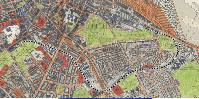
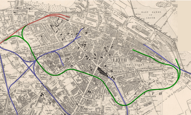
Line of the Pilrig to Seafield section of the Caledonian Railway, traced over a 1971 OS land use survey map on a 6-inch to the mile base map, 1966 survey. CC-by-NC-SA via National Library of ScotlandThis section of railway, formally known as the Leith New Lines, was one of the last to be built in the city and did not open until 1903. Its purpose was to give the Caley access from its existing line into Leith Docks from the west to the expanding eastern portion of the docklands. It would cut its way through the dense industrial heartlands of Leith and Bonnington, serving these with large and convenient new goods stations.
Ordnance Survey 6-inch scale map of Leith, 1906. The North British Railway is highlighted blue, the Caledonian Railway in red and the Leith New Lines in green. Reproduced with the permission of the National Library of ScotlandOn paper this was a sound proposal but by this time the best potential routes through Leith were already well built on, therefore it had to take a winding and circuitous route requiring substantial and expensive engineering. There were numerous cuttings and viaducts required plus skew girder bridges over thoroughfares at Bonnington Toll, Leith Walk and Easter Road. As if that wasn’t enough, it also had to cross three different North British Railway lines, the Water of Leith and cut beneath Ferry Road.
https://www.flickr.com/photos/127340508@N05/40040319893/
This railway never fulfilled its potential, a planned passenger service was never introduced and its twin tracks soon singled. The western section between Newhaven and Bonnington closed in 1965. In 1968 the low bridge over Bonnington Toll was removed and the goods station off Leith Walk at Stead’s Place (Leith Walk West) was closed. For a few years the eastern section at Seafield lingered on giving access to the Leith East goods yard at Salamander Street but this too closed in 1973, making the entire line redundant. British Rail gave notice at this point that it intended to demolish its monumental girder bridges over Leith Walk and Easter Road plus a smaller one over Halmyre Street to reduce their maintenance burden.
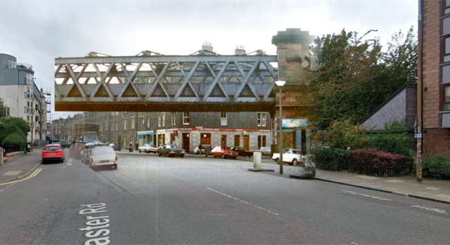
Easter Road #NowAndThen image overlay showing the Caledonian Railway bridge in 1974 and the modern Google Streetview background. Original from Edinphoto. This bridge was removed between January and February 1980.The 1975 path scheme saw the opportunity to purchase the route from British Rail before they proceeded with demolition and proposed to replace these large, expensive structures with lightweight footbridges and to retain the smaller bridge over Halmyre Street. This would give an elevated walkway from Pilrig Park, across the arches of the viaducts at Jane Street, Manderston Street and Gordon Street and from there along the embankments and cuttings all the way to Seafield.
Cover, City of Edinburgh, Leith Local Plan, Draft Final Report, April 1975. Volume Two. Schedules and Appendices.Proposal diagram for the Leith Walk Sawmills and Caley railway yard land off of Pilrig Park.The bridges at Easter Road and Manderston Street would be removed in early 1980, with that over Leith Walk following in September that year.
It have assumed that because the bridge over Halmyre Street was to be retained that the viaduct between there and Easter Road, which cut its way rudely through the back greens between Gordon Street and Thorntree Street would have been kept too.
1929 aerial photo showing the trackbed of the Leith New Lines between Easter Road (bottom right) heading west towards Leith Walk (top left). The large roof to the top right of the photo is Leith Central Station. That building along with the tenements along the line of Manderston and Gordon Streets have since been demolished. The large white roof belongs to the Capitol cinema, until recently a bingo hall. SPW027351 via Britain from Above.This ambitious urban realm scheme of course never came to pass. By the time an updated version of the Final Plan was published in 1980 it had been quietly dropped. One assumes this was because of the disruption caused to local government when the old unitary Corporation of the City of Edinburgh was replaced in 1975 and split up into the two-tier system of Edinburgh District Council and a combined Lothian Regional Council. Instead there was a cut back scheme to purchase the trackbed between Seafield and Easter Road and to landscape it as a pathway with funding from the Scottish Development Agency (SDA). While this at least did come to pass, the word “landscape” is doing a lot of heavy lifting and in reality this path was really just a strip of compressed dirt covered in dog mess and rubbish, with obstructive barriers to try and stop you cycling it without getting off and pushing. This would not be remedied until around 2010 when it was properly surface, the barriers were removed, new access points were added and lighting was provided.
Excerpt from 1980 report.Item 26 on the above list, the railway embankment through Pilrig Park, did also ended up being achieved although the link through to Leith Walk never happened. The viaduct from Pilrig Park to Leith Walk remains fence off, although recent redevelopment on the site of the former Leith Walk West goods yard means there is now a rather roundabout connection some 45 years later through an access road.
Looking along the viaduct above Jane Street towards Leith Walk on a very grey day in 2021. Photo © SelfItem 27, the second walkway which was planned in both 1975 and 1980, along the old North British Railway trackbed alongside the Water of Leith, from Coburg Street to Warriston, would come to pass. This opened in June 1982, making it the first old railway track to formally be converted to a foot and cycle path in Edinburgh, and the first of many more miles to come.
Line of the Coburg Street to Wariston section of the North British Railway, traced over a 1971 OS land use survey map on a 6-inch to the mile base map, 1966 survey. CC-by-NC-SA via National Library of ScotlandThe opportunity to do something between Pilrig Park and Easter Road is one that has never been properly grasped. In more recent times (although over 10 years ago now!) there was a semi-serious attempt to drum up interest in reviving the idea, with a connection between Pilrig Park and Halmyre Street achieved by building a show-piece timber and cable bridge across Leith Walk. How serious this actually was I do not know, I don’t recall any funding ever being in place even for planning, and providing level access to street level at the Thorntree Street end remains a difficult proposition. Even if it had been approved, like other schemes such as the section of Railway between Powderhall and Meadowbank, there’s a very good chance that it would still find itself in development limbo.
Renderings by Biomorphis of their engineered timber and cable bridge structure they proposed over Leith Walk.But if you happen to find yourself walking along past the garages which occupy the Manderston and Gordon Street arches, it’s easy to forget that there’s actually a railway station platform up there above your head, one which was built over 120 years ago but never actually opened. Although some lucky souls in the path have at least had the chance to get off a train there and head down its stairs to street level…
Note to readers: unfortunately in April 2026, a third-party plug-in more than exceeded its authority and broke many of the image links on this site. No images were lost but I will have to restore them page-by-page, which may take some time. In the meantime please bear with me while I go about rectifying this issue.
If you have found this site useful, informative or amusing then you can help contribute towards its running costs by supporting me on ko-fi. This includes my commitment to keeping it 100% advert and AI free for all time coming, and in helping to find further unusual stories to bring you by acquiring books and paying for research.
Or please do just share this post on social media or amongst friends and like-minded people, sites like this thrive on being shared.
Explore Threadinburgh by map:
Travelers' Map is loading...These threads © 2017-2026, Andy Arthur.
NO AI TRAINING: Any use of the contents of this website to “train” generative artificial intelligence (AI) technologies to generate text is expressly prohibited. The author reserves all rights to license uses of this work for generative AI training and development of machine learning language models.
#Lochend #Logan #Restalrig #StMargaret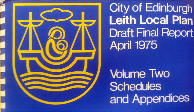
The thread about #NowAndThen photo montages of old railway stations, tramways and bridges around Edinburgh and Leith
This thread was originally written and published in December 2017 and a further part in May 2019.
This thread features #NowAndThen photo-montages of long gone railway stations, tramways and bridges in Edinburgh and Lieth; period photos overlaid on the current streetscape to show just how much or little things have changed over time.
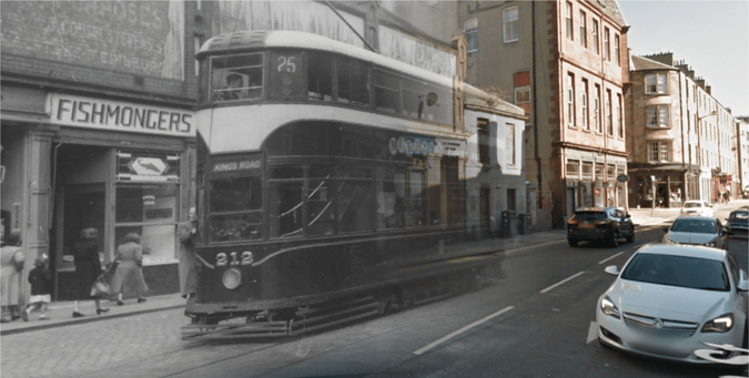
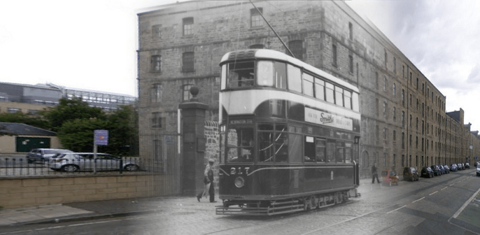
Duke Street in 1954 on the last day of service for the No. 25 tram. This service ran from Corstorphine to Portobello King’s Road via Leith Walk and the Links. Not much else has changed on this side of the road, although the occupants of the buildings certainly have. On the left was the Palace Cinema, with a snooker hall above. It is now a J. D. Wetherspoon pub.
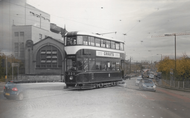
No. 25 Tram at Duke Street. Original image © Kenneth G. WilliamsonCommercial Street in 1955. The No. 17 tram from Granton passes the “Highland Queen” bonded warehouse of MacDonald and Muir. It is running across the railway lines that crossed into the docks from the former North British railway at North Leith / Leith Citadel station. The bond is now flats, through the West Dock Gate where the railway ran is the now the Scottish Government building – Victoria Quay. The Old West and East docks are infilled, unimaginatively used as car parks. The Victoria Dock is cut off from the harbour basin and is a sterile and bleak water feature in front of Victoria Quay.
No. 17 tram at Commercial Street. Original image © Kenneth G. WilliamsonKing’s Road at Portobello in the 1950s. The No. 12 tram from Corstorphine via Leith, it has just passed the ghost of a car heading the other way to Portobello. The background is dominated by the great red brick lump of Ebenenzer J. Macrae’s Corporation electric power station.
No. 12 Tram at the King’s Road. Original image © Kenneth G. WilliamsonTollcross in 1956. There was a tramway depot here – where the central fire station now is – and the route was also a junction where 3 routes from the suburbs converged and then split immediately into two to head into the city by different routes. As such this was always a busy place on the network and this scene is busy with shoppers and tramcars. The tenement on the right and the castle are all that remain of the original buildings in this shot now.
Trams at Tollcross. Original image © Kenneth G. WilliamsonTrinity Crescent in the 1950s. A no. 17 tram squeezes under the bridge carrying the railway from Trinity Station along Lower Granton Road to the docks. The low bridge and tight S-shaped turn of the road meant that the tramway here was single line in the middle of the road, with the overhead line lowered. A set of traffic signals allowed only 1 tram at a time into this short section and warned motor vehicles that a tram was about to pass as their route swung onto the right lane to make the turn.
No. 17 at Trinity Crescent.And Trinity again in 1986. A ghost train crosses Trinity Road on track removal duties. Click on the link to the EdinPhoto website to see more images of this series.
Trinity railway bridge in the 1980s. Original photo © Peter Stubbs.Moving on to animated transitions, here is Balgreen Halt station. A 1934 addition to the suburban railway network by the LNER (London & North Eastern Railway), it was closed in 1968. Estimate the old photo is early 1960s.
Balgreen Halt. Original CC-BY-SA Ben BrooksbankAnd at the end of the line at Corstorphine. Always a hard one to get your head around as no hint of the stations presence is left under the 1980s housing, beyond the name “Station Road”
Corstorphine Station, 1926. Original Image © Edinburgh City LibrariesSide fact, Corstorphine had extraordinarily long platforms for a suburban station (250m, sufficient for a 12 coach train of 60 foot stock), I believe this was because the railway company hoped that a new barracks to replace the Georgian cavalry establishment at Piershill would be built nearby. The new barracks were ultimately built at Redford instead but Corstorphine was left with its overly large station. There were 2 full platforms and 2 full length carriage sidings. As a result it was used to stable and clean coaching stock overnight and on occasions such as rugby and football matchdays.
Another overlooked Edinburgh suburban station; the awkwardly located Piershill at the foot of Smokey Brae, between Meadowbank and Restalrig. The road here running under the bridge is Clockmill Road, which connected to the Clockmill Lane. This was the ancient route from the Canongate to Restalrig, cut in two by the London Road when it was built in the early 1820s. The road was obliterated and the bridge cut off by the groundworks for the 1970s Commonwealth Games stadium, the velodrome being built on top of the road. The bridge is now blocked up as a garage, but may be re-opened as a through route in the future when the eastern end of the stadium site is redeveloped as housing.
Piershill Station. Original Image © CanmoreLeith Walk station – no, not the big one at the Foot, but the one called Leith Walk towards the top.The demolished tenements of Shrub Hill and Shrub Place are in the background, plus an intriguing belfry. I’m guessing it was the old school next to Pilrig Model Buildings, which later became the “Royal Caledonian Bazaar”.
Leith Walk station, 1890s. Original from The Story of Leith by John RussellNow the site of the Inchkeith House multi-storey flats, the Royal Caledonian Bazaar was a “posting and livery establishment”; basically a horse transport depot. The proprietor was one John Croall. The Croalls were established in the horse business and were pioneers of motoring in Edinburgh. They gave their name, unsurprisingly, to Croall Place, the tenement at the top of Leith Walk where it meets Macdonald Road. Croall & Croall later built car and bus bodies and had a number of works around the West Port and Lothian Road. They later became part of the SMT (Scottish Motor Transport) empire.
Granton Road, once an important suburban commuter station and tram route. It was much more conveniently located for the wealthy suburb of Trinity than the station of that name, and later for the big new housing scheme at Boswall.
Granton Road station, 1955. Original image © Kenneth G. WilliamsonThere’s an old cast iron column just outside where the station was, I always assumed it was a tramway pole for the overhead wires. This photo shows it supported no wires – there’s an actual tramway pole right behind it – and it had a crown-shaped vent cap. It’s not a pole or a lamp post at all, it’s actually a sewer vent – a stink pipe – which is why it has survived.
We move on to Granton station itself. One of the first in Edinburgh and originally the site of a pioneering train ferry to Burntisland before the Forth was bridged. It closed in 1925 as an economy as there was little need by this time for a passenger station in the middle of the docks – most people taking the ferry across the Forth found the electric tramway much more convenient to get into the city than taking the train.
Granton Station, pre-1925. Original image © Kenneth G. WilliamsonThe slip for the train ferries is still used by the Royal Forth Yacht Club. Thomas Bouch’s Floating Railway was an ingenious and effective solution to bridging the Forth before the technology allowed a permanent structure. Basically an early, steam-raised linkspan that lowered a ramp on to a special ferry boat, allowing wagons and carriages to be run aboard. The whole apparatus, rails and all, was on a great wheeled carriage, allowing it to move with the tides. The rails were in short sections, bolted together in such a way that they could flex.
Bouch’s “floating railway”, a rather ingenious solution to the problem of bridging the Forth by railThomas Bouch is an engineer remembered for his greatest and most infamous creation, the first Tay Bridge, but he had a long career in which he constructed many pioneering and innovative solutions to the problems of getting railways across obstacles.
I’m quite chuffed with this image, which shows the evolution of the Upper Drawbridge at Sandport Place. Not only is the river much higher now since the docks were dammed, but the deck was widened and the central arch of the current bridge replaced the lifting section.
The “Upper Drawbridge” over the Water of Leith. Original Image © Peter StubbsThe Water of Leith is no longer a tidal river, as in the 1960s a set of lock gates were installed at the mouth of the docks to keep the dock basin always filled with water to allow bigger and deeper ships to use the port, and not be so restricted by the tides when coming and going. The water level these days is frequently within a foot of the central arch but you can still see the “river bed” in the right conditions only a few feet below that, there must be a good 20 foot of mud and silt and sludge built up on the river bed, unable to be washed out by the tide.
The next image is the same spot as before but looking the other way, to St. Ninian’s Wharf (named for the old North Leith Kirk behind, with its distinctive Dutch tower). The site of a dry dock and boatbuilding yard in the 1850s and 60s.
St. Ninian’s Wharf, original image by Thomas Vernon Begbie, taken in the 1850s. © Edinburgh City LibrariesThe photo confused me for a good while, as I assumed that the ship must be in the dry dock, which was one of the first dry dock in Scotland so pre-dated the photo by about 100 years. I later realised that the ship being built in the picture is not in the dry dock at all, but on a building slip alongside, with a temporary coffer dam following the line of the river wall – marked in red on the Town Plan below.
OS 1849 Town Plan. Reproduced with the permission of the National Library of ScotlandThat ship may even be on a “patent slip”, a Leith invention.
Note to readers: unfortunately in April 2026, a third-party plug-in more than exceeded its authority and broke many of the image links on this site. No images were lost but I will have to restore them page-by-page, which may take some time. In the meantime please bear with me while I go about rectifying this issue.
If you have found this site useful, informative or amusing then you can help contribute towards its running costs by supporting me on ko-fi. This includes my commitment to keeping it 100% advert and AI free for all time coming, and in helping to find further unusual stories to bring you by acquiring books and paying for research.
Or please do just share this post on social media or amongst friends and like-minded people, sites like this thrive on being shared.
Explore Threadinburgh by map:
Travelers' Map is loading...These threads © 2017-2026, Andy Arthur.
NO AI TRAINING: Any use of the contents of this website to “train” generative artificial intelligence (AI) technologies to generate text is expressly prohibited. The author reserves all rights to license uses of this work for generative AI training and development of machine learning language models.
#Lochend #Logan #Restalrig #StMargaret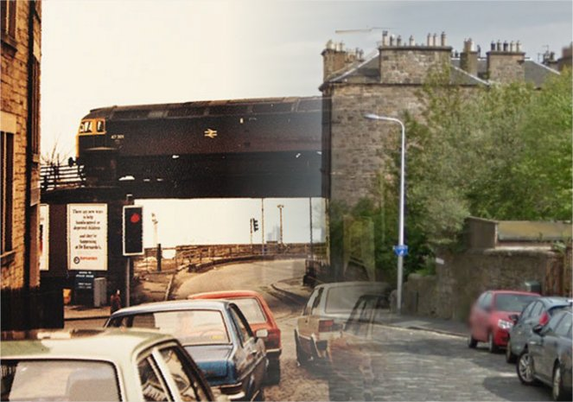
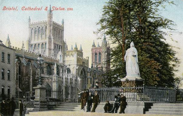
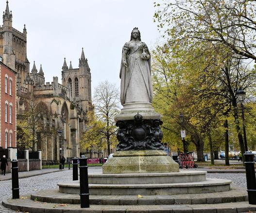
Bristol Cathedral & Statue, c.1910 & 2022.
The statue has moved slightly so the angle is different (and there's a busy street directly behind me that I was trying not to step into).
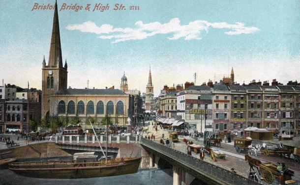
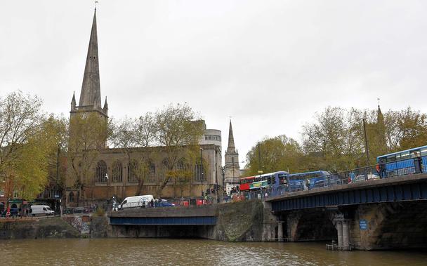
Bristol Bridge and High & Baldwin Streets, c.1910 and October 2022