#NWSWakefieldVA new Forecast Discussion model leads with the lay part and closes with forecaster inside baseball. The key points are usually clear statements of what is coming with the discussion explaining how forecasters arrived at the key forecast guidance.

The other place to look is for the local county forecast. Clicking on your county in the hazards map will take you there. These are the work of the operational forecast system.

#NWSWakefieldVA to be out of service June 10 - June 12 for software updates to the forecast product production system.

https://www.weather.gov/akq/WakefieldOOS

In the fine print, weather radio transmission will be interrupted during the work.

Moorehead city will be picking up warning duties during the outage.

NWS Wakefield Software Upgrade Jun 10-12

#NWSWakefieldVA just issued (1206Q) a flood warning for training rain cells. No thunder or wind, just rain with accumulation up to 5 inches in spots.

Checking out gadget, 21 mm rain has fallen since the start of festivities about 3 hours ago. Warning runs to 1515Q with an additional 50 mm accumulation possible. 25 mm is a skimpy inch. #VAwx

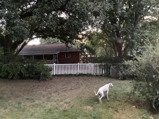
Ahoy all. Dismal Manor Gang has sallied forth briefly for comfort runs. Local conditions remain humid, overcast and breezy.

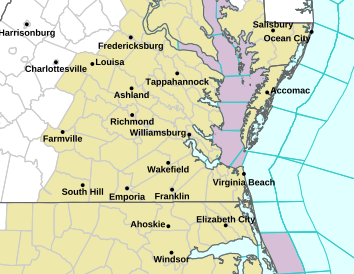
#nwswakefieldva writes …

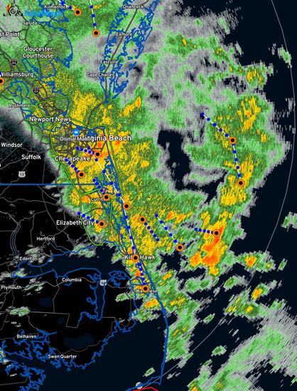
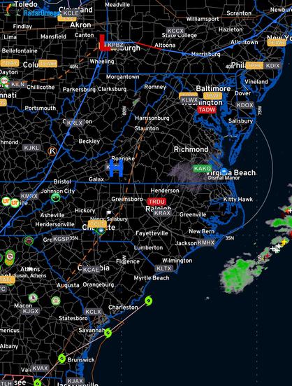
Impacts from TD Debby continue into tonight. Precipitation becomes a bit more showery in nature across central/eastern portions of the area as the remnants of TD Debby exits to the north.

- The tornado threat is waning but does persist early this morning mainly along the coast. A lower-end tornado threat remains for this afternoon into early evening, with a Day 1 Slight Risk from SPC. Also. tornado survey work from yesterday`s storms will begin later today. Findings will be posted as soon as is possible.

https://forecast.weather.gov/product.php?site=AKQ&issuedby=AKQ&product=AFD&format=CI&version=1&glossary=1&highlight=on

#NWSWakefieldVA Thursday evening forecast text. Remember them? Summary, more TD weather possible Thursday evening into Friday.

PS: I’m keeping my wheelie bins in!

National Weather Service

https://www.weather.gov/media/akq/briefings/LatestBriefing.pdf
1200Q Monday #NWSWakefieldVA boffins have the briefing for the week out. Teal leaves have settled sufficiently to permit a forecast

It appears Debby will be making a port call in some form bringing lots of rain, heavy at times.

Debby will exit rapidly Saturday and Sunday.

Yes, flooding is possible. In the usual places. And more if accumulation is rapid.

Plan to park in city garages. Have medications and plenty of pantry foods on hand.

#hurricanedebby #VAwx

#NWSWakefieldVA
Boffins have an official summary forecast advising that additional rain is possible Sunday with cooler temperatures. Weatherflow expects rain midafternoon
#NWSWakefieldVA #NWSNHC_Atlantic

Sunday sunrise greets a partially dismal day. Humidity is down some, 21.5 C down from 24 C. Morning temperature is 24c. 40% probability of afternoon thunderstorms. Yesterday’s drama stayed just to our west.

#NWSWakefieldVA boffins have issued a small craft advisory …

* WHAT...Southwest winds 15 to 20 kt with gusts up to 25 kt and waves 2 to 3 ft.

* WHERE...Chesapeake Bay from New Point Comfort to Little Creek VA and Chesapeake Bay from Little Creek VA to Cape Henry VA including Bay Bridge

This RadarOmega image captured circa 0810 shows the trough at the mountains like Friday evening.
#NWSWakefieldVA

Today’sforecast is more concerned about dangerous heat which is a sure thing.

Thursday thunderstorms were isolated. Like 4 in the AOR. None required warnings.

Friday conditions are similar, heat but no trough or front to initiate widespread storms.

#NWSWakefieldVA #VAwx