Who Smote Whom? The geography of Israelite Transjordan (I)
I’ve been trying to get a grip on the geography of two large-ish areas east of the River Jordan that the Hebrew Bible says were once populated by Israelites: Gilead and Bashan. The boundary between these two matches the modern border between Jordan and Syria pretty well, with Gilead corresponding to part of northwestern Jordan and Bashan to the Syrian region of Hauran. But there’s some issues. The use of Gilead is pretty inconsistent: sometimes it seems to refer to just a small part of the area, not all of the Israelite East Bank. There’s conflicting statements on which tribes lived where. And in the case of Bashan, there’s a special focus on the district of Argob: where’s that?
https://www.youtube.com/watch?v=8OsA1CSdgYY
The kind of average, overall picture we get from the canonical bible as a whole isn’t too complicated. Approaching Canaan after their desert wanderings, the Israelites are attacked, first by Sihon, king of the Amorites and then by Og, king of Bashan. The Israelites defeat them and certain tribes and subtribes settle in their lands, divided as follows:
- Gilead is divided between the tribes of Reuben, Gad, and half of the tribe of Manasseh.
- Other clans belonging to the same half tribe of Manasseh get Bashan.
- Some subregions get conquered by specific individuals, like Jair who names his portion Havvoth-Jair and Kenath, which is conquered by Nobah.
But zooming in on the actual texts, things get more complex. In this Part I post, we’ll mainly be looking at Numbers 32, Deuteronomy 3, and Joshua 13.
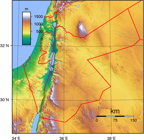
Map for reference, by Wikimedia user Sadalmelik. The river running into the middle of the Dead Sea is Wadi Mujib, the Arnon. The one running into the middle of the Jordan valley is the Zarqa River, the Jabbok. The western part of the Jordanian-Syrian border follows the Yarmuk. The River Jordan runs north to south along the modern kingdom of Jordan’s border, into the Dead Sea.Gilead: who goes where?
For starters, the different accounts of how the territories of Reuben and Gad relate to each other are hopelessly confusing, if not confused; Yigal Levin gives a much better overview here than I could.
Levin identifies three distributions:
After staring at Levin’s maps for a long time, the main disagreement seems to be about who controls the area between the Arnon and Wadi al-Hidan, with the towns of Dibon and Aroer: Gad in Numbers 32 (where they also hold the southwestern town of Ataroth), but Reuben in Joshua 13. Otherwise, there’s a disagreement about the border town and former Amorite capital of Heshbon, but the general picture is the same, with Gad in the north by the Jordan and Reuben in the south by the Dead Sea.
Interestingly, there’s another contender for the area south of Wadi al-Hidan: Moab.
I am Mesha, son of Chemosh[ît], king of Moab, the Dibonite
…
Omri had taken possession of the land of Madaba … but Chemosh restored it during my days. I built Baal-meon, and I made a reservoir in it; I built Kiriathain. The men of Gad dwelt in the land of Atarot from ancient times, and the king of Israel had built Atarot, but I fought against the city and took it; I killed the entire population.
…
Chemosh said to me: “Go, take Nebo from Israel!” I went in the night, and I fought there from dawn until noon; I took it and killed everyone
…
The king of Israel had built Yahaz, and he lived there while fighting against me, but Chemosh drove him out before me
…
I built Aroer and made the road in the Arnon
…
I (re)built Beth-Bamoth because it had been destroyed. I (re)built Bezer because it was in ruins.
We can divide the places that overlap between the Mesha inscription (ca. 840 BCE) and the biblical accounts of Reuben and Gad’s territories into three categories, based on what Mesha says about them:
Of the places in group 1, Beth-Bamoth/Bamoth-Baal has not been identified. If we connect it with Baalei-Bamoth-Arnon in Num 21,2 it would appear to lie on the Arnon. Dibon and Aroer are on the north bank of the Arnon. The location of Bezer has not been identified but most of the biblical mentions specify that it lies “in the desert”, which, like the rest, plausibly places it south/east of Wadi al-Hidan. This is the area where Num 32 and Josh 13 show the most disagreement.3
Of the places in group 2, Medaba, Baal-Meon, Kiriathaim, and Nebo all lie north/west of Wadi al-Hidan. The wonderful Ortsangaben der Bibel suggests Khirbet er-Rumel as the most likely location of Jahaz, which lies on Wadi al-Hidan. These places are never attributed to Gad, only to Reuben.4
Finally, Ataroth (group 3) lies north of Wadi al-Hidan, close to where it joins the Arnon. Both Mesha and Num 32 mention it as belonging to Gad, and it is never attributed to Reuben.
Together with the other places from Num 32 and Josh 13 that have been identified, I think this makes for a geographically plausible division that explains the disagreement between the biblical sources:
That gives us a satisfactory division of Gilead.
…
This is Gilead, right?
Where is Gilead?
Most of the story in Num 32 seems to be about Gilead (vv. 1, 26, 29). But then, right after Moses gives the territory in question to Gad and Reuben in v. 33,5 we read:
And the sons of Machir, son of Manasseh, went to Gilead and captured it. And he dispossessed the Amorites that were there. And Moses gave the Gilead to Machir, son of Manasseh, and he settled there. And Jair, son of Manasseh, went and captured their villages, and called them Jair’s Villages (Havvoth-Jair).
Num 32:39-41
(Havvoth-Jair is in Gilead according to Judges 10 and 1 Kgs 4, but in Bashan according to Deuteronomy 3 and Josh 13.)
OK, so Gilead is somewhere else? And Manasseh lives there? About that:
And [Jephthah] passed through the Gilead and Manasseh
Jdg 11:29
Gilead lies in between Ephraim and Manasseh.
Jdg 12:4
Josh 13 seems confused about this as well:
And Moses gave to the tribe of Gad … And their border was Jaazer and all the towns of the Gilead … the Jordan being the border, until the edge of the Sea of Kinnereth, the east bank of the Jordan.
Josh 13:24-27
And Moses gave to half the tribe of the Manassites … And their border was from Mahanaim … and half of the Gilead …
Josh 13:29-31
We also find seemingly contradictory statements right in the same passage in Deuteronomy 3, a more general statement about the division of Transjordan that we haven’t considered yet (Moses is speaking):
At that time, we took the land from the two Amorite kings that were in Transjordan, from the Arnon gorge to Mount Hermon. … All the towns of the Mishor and all the Gilead and all the Bashan, as far as Salcah and Edrei, Og’s royal cities in the Bashan. … At that time we took possession of that land. From Aroer on the Arnon gorge and half of Mount Gilead and its towns I gave to the Reubenites and the Gadites. And the rest of the Gilead and all of the Bashan, the kingdom of Og, I gave to half of the tribe of Manasseh … and to Machir I gave the Gilead. And to the Reubenites and the Gadites I gave from the Gilead until the Arnon gorge, the middle of the gorge being the border, and until the Jabbok gorge, the border of the Ammonites.
Deut 4:8-16
Here, we see a threefold division into the Mishor, the Gilead, and the Bashan. Gilead is split between Reuben/Gad and half of Manasseh, or entirely given to Machir.
Finally, there’s Genesis 31-33, where the patriarch Jacob names a bunch of places in “the hill country of Gilead”: a town of the same name (probably), Mizpah, Mahanaim, Penuel, and Succoth. As far as we can tell, these were all pretty close together, in the hill country north of the Jabbok. In the same region, we later on find the places Jabesh-Gilead and (probably) Ramoth-Gilead.
The contested nature of Gilead is also reflected in tribal genealogy: Gilead is a grandson of Manasseh and a son of Machir according to Num 26:29, 27:1; Josh 17:1,3, but appears as a separate tribe besides Machir in the Song of Deborah, Jdg 5:14,17 (interestingly, neither Manasseh nor Gad is mentioned here). Gilead also appears to be an independent tribe in Jdg 11, the story of Jephthah, and also note Jair (of Havvoth fame) as a Gileadite, not a son of Manasseh, in Jdg 10.
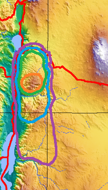
Let’s try to make some sense of this from a diachronic point of view. Map below.
Map:
Orange: Gilead 1.0 (separate tribe). Green: Gilead 2.0 (Machir). Blue: Gilead 3.0 (Machir and Gad/Reuben or Gad). Purple: Gilead 4.0 (Gad and Reuben).So in combination with what we saw about the borders of Moab in the first section, this suggests the following division as the oldest one we have evidence for (roughly correlated with modern Jordanian governorates because that works pretty OK):
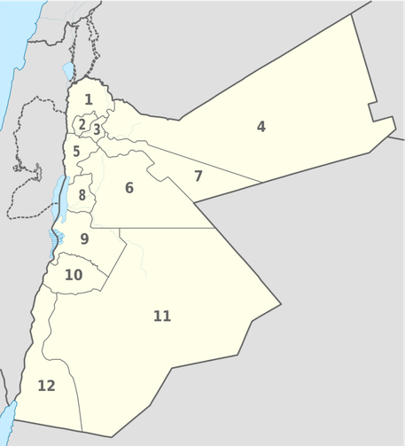
regiontribe/kingdomgovernorate (# on map)Wadi al-Hidan to ArnonMoabpart of Madaba (8)Mishor northwest of Wadi al-HidanReuben/Israelpart of Madaba (8)Jordan and Dead Sea coast south of JabbokGadmostly Balqa (5)hill country north of JabbokGileadAjloun (2), Jerash (3)plateau south of YarmukMachirIrbid (1)headwaters of JabbokAmmonparts of Mafraq (4), Amman (6), Zarqa (7)Map by Wikimedia user TUBS.To sum up the diachronic story, we see Gilead creeping a little bit north and then a lot south, Machir/Manasseh creeping a little bit south and then moving north, and Gad expanding north. What’s going on up there? In Part II, we will turn and ascend the road to Bashan to find out.
#Bible #Deuteronomy #Hebrew #Joshua #Judges #Kings #Moabite #Numbers