USGSLiDAR [easier USGS 3DEP elevation data access]
--
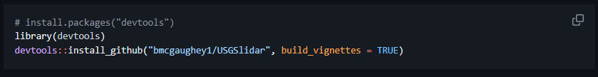
https://github.com/bmcgaughey1/USGSlidar <-- shared GitHub repository
--
#GIS #spatial #mapping #entwine #remotesensing #opendata #spatialanalysis #processing #automation #opensource #USGSLiDAR #LiDAR #3dep #elevation #3delevation #3delevationprogram #USGS #webserver #index #entwineindex #PDAL #pipelines #download #pointdata #pointcloud #clipped #MicrosoftPlanetaryComputer #MPC
@USGS
--
https://github.com/bmcgaughey1/USGSlidar <-- shared GitHub repository
--
#GIS #spatial #mapping #entwine #remotesensing #opendata #spatialanalysis #processing #automation #opensource #USGSLiDAR #LiDAR #3dep #elevation #3delevation #3delevationprogram #USGS #webserver #index #entwineindex #PDAL #pipelines #download #pointdata #pointcloud #clipped #MicrosoftPlanetaryComputer #MPC
@USGS


GitHub - bmcgaughey1/USGSlidar: A collection of functions to browse lidar data collections, query collections for coverage for specific locations, and retrieve data covering locations.
A collection of functions to browse lidar data collections, query collections for coverage for specific locations, and retrieve data covering locations. - bmcgaughey1/USGSlidar