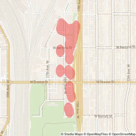
Seattle City Light is reporting a medium outage in the Interbay area.
Start Date: Jan 7 10:48 PM
Est. Restoration: Jan 8 9:00 AM
Cause: Investigating
Seattle City Light is reporting a medium outage in the Interbay area.
Start Date: Jan 7 10:48 PM
Est. Restoration: Jan 8 9:00 AM
Cause: Investigating
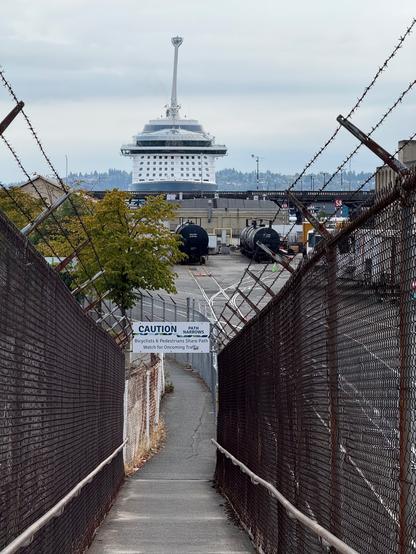
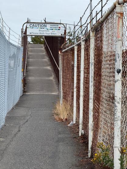
Why the Port didn’t fix the ‘Path Narrows’ south of the removed Interbay trail bridge
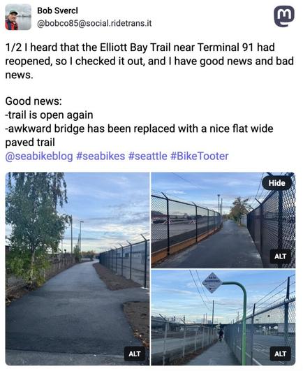
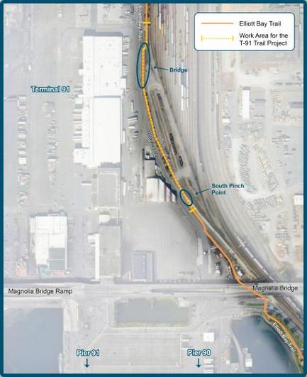
When the Port of Seattle initially announced the Terminal 91 Trail bridge removal project back in 2023, they were also planning to widen the “Path Narrows” pinch point where the fences squeeze the trail just south of the old bridge. So when folks like Bob Svercl went to give the new trail a ride, they were surprised to find that while the bridge has been replaced with a smooth and wide trail, the 5-foot-wide pinch point is still there.
Post by @bobco85 View on Mastodon
Bob measured and found that from fence-to-fence, the width is about five feet, but the usable width is even skinnier. So Bob went back to the project website and realized that all mentions of the pinch point had been scrubbed. He then checked the Wayback Machine, and sure enough this spot used to be listed. So Bob asked the Port why the Path Narrows were still there, and Project Manager Mark Longridge said they did not figure out an easement agreement with BNSF in time and didn’t want to delay the bridge project:
“The southern pinch point is constrained by the BNSF property line on the east side, and an existing port building and roadway to the west. Unfortunately, we were not able to work out an easement with BNSF to move this alignment east without impacting their yard road and did not want to delay the bridge removal and other parts of the work any longer waiting for a possible design solution for the south pinch point. The good news is that the building to the west is now slated for removal in the next couple of years as part of a bigger project and the plan is to potentially realign the road to address this remaining narrower section. While we would have preferred to do all of this work together, we wanted to get as much of the trail fixed as soon as possible.”
-- Advertisement -- The project website initially included widening the “South Pinch Point” AKA “The Path Narrows.”So the pinch point is still on the to-do list, and the overhead sign gives it a great name: The Path Narrows. Not quite as famous as the Tacoma Narrows. Before the bridge was removed, the Narrows were just one part of a string of pinch points and awkward spots, but now that it is all alone it really stands out.
Also, a note to project teams: Please don’t just remove things from official materials without adding comment explaining why. I think most people would accept the Port’s explanation about issues fixing this pinch point. A similar issue came up in a much worse way this summer when Seattle Parks quietly removed most of the planned safety upgrades from the Lake Washington Boulevard project and then did not mention the cuts at all when publicizing the new much shorter upgrade list. We had to use the Wayback Machine to find those cuts, too.
#SEAbikes #Seattle
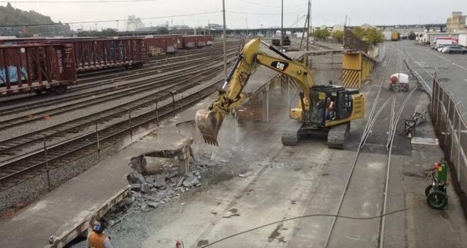
With the bridge over nothing removed, the Terminal 91 Trail in Interbay reopens Thursday
Screenshot from a Port of Seattle video.The skinny trail bridge over a driveway in Interbay that the Port of Seattle has not used for decades is now gone along with the various pinch points it created. The Port will reopen the trail on schedule Thursday morning (October 2), one month after the closure began.
Reopening the trail is great news for folks who have been dealing with a poor detour route for the past month that put two-way trail use on one skinny sidewalk on the Magnolia Bridge. It also required using a spiraling ramp with tight turns that are not particularly comfortable to ride for all users.
The reopened trail is at ground level, and the Port says the space for the trail will be widened to remove the old choke points where only one person could fit at a time. This is a significant improvement to the Elliott Bay Trail, which became a lot more useful when the downtown waterfront bikeway opened. We won’t see the trail in its full glory until the Myrtle Edwards Park remake project (“Elliott Bay Connections“) reopens all the park paths, likely next year. Until then, people walking and biking will share a single path. It’s certainly usable, but you gotta be patient because there are often a lot of people.
Watch workers tear down the old trail bridge (though I don’t know why they keep calling it a “bridge to nowhere” when it definitely went places. It was more like a “bridge over nothing”):
#SEAbikes #Seattle
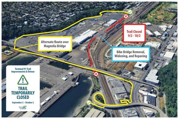
The Port of Seattle is making some long-needed changes to the section of the Elliott Bay Trail that travels through the Terminal 91 rail yard in Interbay, including widening pinch points and removing the steep and skinny trail bridge. The trail will be closed for a month starting September 2, and the marked detour will direct trail users on a meandering route that includes a very skinny sidewalk on the Magnolia Bridge.
“This project will improve the Port’s segment of the trail including removing the bike bridge, widening the narrow areas, and providing new paving,” according to the project website. We reported on the $1.525 million project back in 2023, but work got delayed a year from the original summer 2024 target.
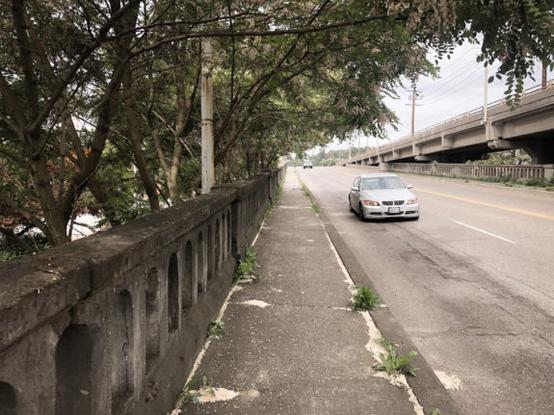
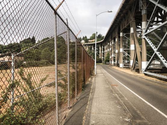
The marked detour will route people off the trail at the E Galer Street Flyover bridge, then down a spiral to the west sidewalk on 15th Ave W. From there, riders would use the south sidewalk on the Magnolia Bridge and down the ramp to meet up with the path on the west side of the terminal at Smith Cove Park. I walked through this detour route (with photos) in a 2023 post about a similar trail closure for repaving work. This time the Port plans to add some water-filled barriers along the Magnolia Bridge sidewalk, which won’t solve the width problem but might make it feel a little more comfortable. The sidewalk is not wide enough for two-way travel, so you will need to be patient and careful when squeezing past other others. People with wide bicycles (trikes especially) should probably consider a different route.
This one sidewalk on the Magnolia Bridge will handle all walking and biking users traveling in both directions.Hmm, are we sure there wasn’t a better spot for this street lamp post?The other option is to ride on 15th Ave W between the Galer bridge and W Dravus Street. 15th has bus lanes and sidewalks but feels like a highway. I would personally take the Magnolia Bridge route instead, though 15th would certainly be faster.
It’s frustrating that the Port again did not figure out a way to do a ground-level detour. When we asked about coning off a temporary path through the terminal back in 2023, a Port spokesperson told Seattle Bike Blog, “Terminal 91 is a working facility with no sidewalks or bike lanes. It is not safe to detour through a working terminal. We are taking feedback on this detour seriously and are raising it with the local transportation agency. We agree there should be a better back-up solution for the future.” Unfortunately, there is still no such back-up solution.
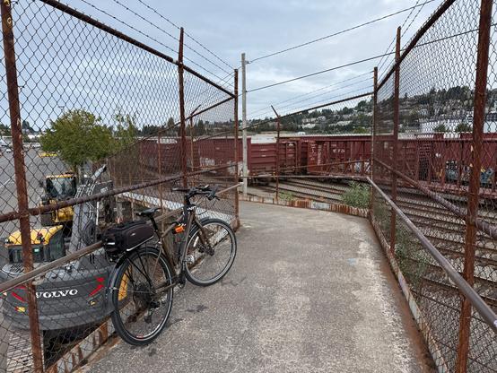
In the end, the result should be a big improvement for biking on one of Seattle’s most unique trails. Built in the late 1980s, the path provides a useful biking and walking connection and one of the more memorable city exploration experiences as riders emerge from industrial Interbay, possibly riding next to 737 fuselages traveling the rails, to a blindingly stunning vista across Elliott Bay.
#SEAbikes #Seattle
Seattle City Light is reporting a medium outage in the Interbay area.
Start Date: Aug 7 9:59 AM
Cause: Investigating
Seattle City Light is reporting a medium outage in the Interbay area.
Start Date: Apr 28 11:02 PM
Est. Restoration: Apr 29 3:17 AM
Cause: Planned Outage
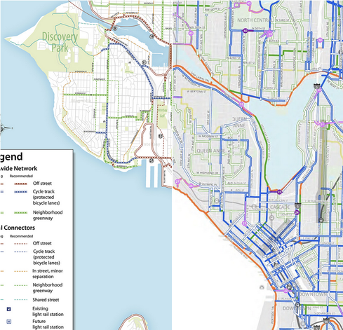
The 20-year bike plan for Downtown, Queen Anne, Interbay and Magnolia
#SEAbikes #Seattle