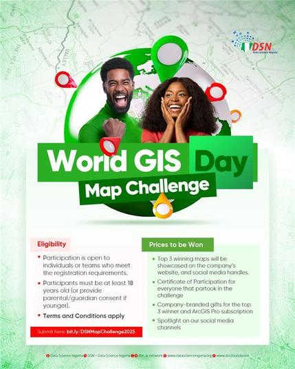
Seven days remain — and the opportunity to leave your mark is closing.

The DSN Geospatial Map Challenge ends on Sunday, 23 November 2025. This is the final call to transform geospatial data into stories, insight and impact that can inspire action across Africa.

Prizes include:
a. DSN-branded gifts + ArcGIS Pro subscription
b. Certificate of Participation
c. Feature on @dsn_ai_network platforms
d. Recognition as one of Africa’s emerging GIS innovators

Geospatial intelligence is shaping planning, health, climate action, mobility, and economic development across the continent. Your map could be the next spark.

Register now → bit.ly/DSNMapChallenge2025

#DataScienceNigeria #WorldGISDay #GeospatialInnovation

🎉 Breaking News: Somebody reinvented the wheel and called it "MapLibre!" 🗺️ It's like the 'next generation' of geospatial formats, because apparently the current ones were getting too mainstream. 🤔 But hey, at least the Simons Foundation is grateful! 😏
https://arxiv.org/abs/2508.10791 #BreakingNews #MapLibre #GeospatialInnovation #SimonsFoundation #NextGenTech #HackerNews #ngated
MapLibre Tile: A Next Generation Vector Tile Format

The Mapbox Vector Tile (MVT) format is widely considered the leading open standard for large-scale map visualization, as evidenced by its widespread adoption by major technology companies such as AWS, Meta, and Microsoft for their products and services. However, MVT was developed nearly a decade ago and, consequently, does not fully align with the capabilities of new geospatial data sources that are characterized by rapidly increasing data volumes due to advancements in geospatial sensors and automated detection through artificial intelligence. In this paper, we introduce the MapLibre Tile (MLT) format, a novel vector tile specification designed from the ground up to address the limitations of MVT. Our experiments, simulating user sessions on widely used basemap datasets, demonstrate that MLT achieves up to three times better compression ratios compared to MVT on encoded tilesets, with over six times better on certain large tiles. Additionally, MLT offers decoding speeds that are up to three times faster and significantly enhances processing performance. MLT also introduces new functionalities and is specifically designed to lay the foundation for the next generation of map renderers, which we expect to entirely offload processing to the GPU, thereby overcoming the stagnation of Moore`s law.

arXiv.org

🎓 GeoTech Alumni Sharing

Proud of Shahin Huseynli, a graduate of the GeoTech Master’s Program, who continues to make waves in the world of climate tech! 🌍

Shahin is a Manager at Detecterra, one of just 10 global startups selected to pitch at COP29’s Early Customer Pitch Day in 2024! 🚀

📌 Learn more about their work: https://detecterra.az/

#GeoTechAlumni #COP29 #ClimateTech #PrecisionAgriculture #RemoteSensing #GeospatialInnovation #Detecterra #GISForGood #Alumni #GIS #Startups

🚀𝗚𝗥𝗔𝗦𝗦 𝗚𝗜𝗦 𝟴.𝟰.𝟭 𝗶𝘀 𝗛𝗲𝗿𝗲!🚀

We're thrilled to announce the release of GRASS GIS 8.4.1. This release brings crucial fixes and improvements to our tools, libraries, and GUI, ensuring a more stable and robust experience.

🔗 Visit https://grass.osgeo.org/news/2025_03_02_grass_gis_8_4_1_released/ to learn more!

💻 Download the latest version: https://grass.osgeo.org/download/

Thanks to all contributors and financial supporters! 🙌

#OSGeo #foss4g #GRASS #OpenSource #GeospatialInnovation
https://grass.osgeo.org/download/

GRASS - Bringing advanced geospatial technologies to the world

GRASS is a powerful open-source geospatial processing engine that supports advanced modeling, time series analysis, and spatial data management.

GRASS

🌐 Exciting Opportunity to Support Innovation in GIScience and Cartography! 🗺️ Join us at the CaGIS+UCGIS Symposium 2024, where cutting-edge advancements in GIS and cartography take center stage. 🚀

🔗 Explore sponsorship opportunities and learn more about the event: [CaGIS+UCGIS Symposium 2024](https://cartogis.org/conferences/cagis2024/)

🎨 Be a part of the future of mapping and spatial sciences! 🌍✨ #CaGISUCGIS2024 #GIS #Cartography #SponsorshipOpportunity #GeospatialInnovation 🌐👥

CaGIS + UCGIS Symposium 2024 – Cartography and Geographic Information Society