New Zealand [3D] Community Fault Model [CFM] [geologic spatial/visualisation]
--
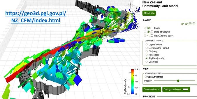
https://geo3d.pgi.gov.pl/NZ_CFM/index.html <-- shared New Zealand Community Fault Model page
--
https://www.gns.cri.nz/research-projects/new-zealand-community-fault-model/ <-- shared community fault model details
--
https://www.gns.cri.nz/data-and-resources/new-zealand-community-fault-model/ <-- shared #GNS downloadable open dataset, ‘NZ CFM v1.0 is a two- and three-dimensional representation of active and potentially active fault zones along the New Zealand plate boundary.’
--
[my upbringing and geology uni degrees were in NZ]
H/T @earth Sciences New Zealand
#geology #maps #NaturalHazards #3D #interactive #faultlines #earthquakes #tech #technology #NewZealand #GIS #spatial #mapping #visualisation #earthquakes #faulting #faultzone #CommunityFaultModel #CFM #opendata #Geo3D #movement #attributes #geometry #risk #hazard #naturalhazard
@GNS Science | @NWIA | @earth Sciences New Zealand
--
https://geo3d.pgi.gov.pl/NZ_CFM/index.html <-- shared New Zealand Community Fault Model page
--
https://www.gns.cri.nz/research-projects/new-zealand-community-fault-model/ <-- shared community fault model details
--
https://www.gns.cri.nz/data-and-resources/new-zealand-community-fault-model/ <-- shared #GNS downloadable open dataset, ‘NZ CFM v1.0 is a two- and three-dimensional representation of active and potentially active fault zones along the New Zealand plate boundary.’
--
[my upbringing and geology uni degrees were in NZ]
H/T @earth Sciences New Zealand
#geology #maps #NaturalHazards #3D #interactive #faultlines #earthquakes #tech #technology #NewZealand #GIS #spatial #mapping #visualisation #earthquakes #faulting #faultzone #CommunityFaultModel #CFM #opendata #Geo3D #movement #attributes #geometry #risk #hazard #naturalhazard
@GNS Science | @NWIA | @earth Sciences New Zealand