The 53rd Weather Reconnaissance Squadron flies modified WC-130J Hercules turboprop military transport aircraft. Their airframes are reinforced to withstand the strongest turbulence at the eyewall boundary. Wind creates extreme vertical accelerations: updrafts and downdrafts literally toss the plane. #WC130J #Hercules #Turbulence #Eyewall #MilitaryAircraft

And there she goes, look at that tight scary little #eyewall. She’s ramping it up now 😬

#idalia

Dramatic satellite videos show rare eye of storm centering over S.F. — San Francisco Chronicle

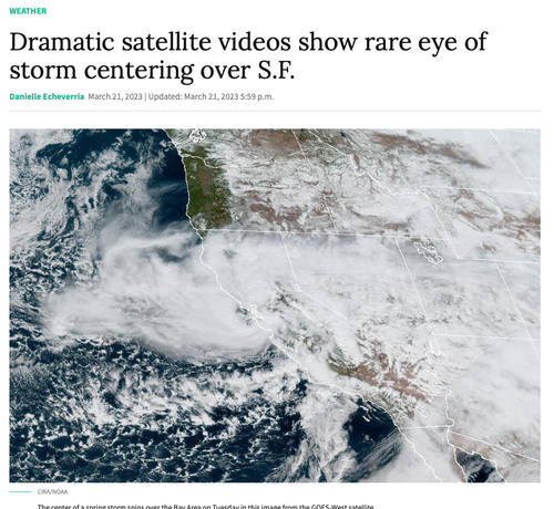
Satellite imagery showed the eye of Tuesday’s storm — a clear spot in the middle of a huge swirl of clouds — making its way toward San Francisco, a marker of just how unusual this spring storm is, according to Chronicle meteorologist Gerry Díaz.

Uhmmmm, this thing looks like it has an #eyewall #atmosphericriver #SF #BernalHeights
RT @Kachelmannwettr
ACHTUNG US-GOLFKÜSTE: Nach dem #ECMWF-Modell könnte die #Eyewall vom möglichen #Hurrikan #Barry am Samstag mit 140 bis knapp 180 km/h zwischen Houma und New Orleans durchziehen! Für Details in die Counties, Stunden vorklicken. https://kachelmannwetter.com/de/modellkarten/euro/louisiana/windboeen-3h/20190713-1800z.html #wetter /CG
Modellkarten für Louisiana (Windböen, 3std) | ECMWF/Global Euro HD (10 Tage)

ECMWF/Global Euro HD (10 Tage) - Aktuellste Prognose für 13.07.2019, 20:00 Uhr des Parameters "Windböen, 3std", Modellkarte mit dem Ausschnitt "Louisiana"