Ecosystem Mapping For Carbon Credit Schemes
--
https://ethicalgeo.org/ecosystem-mapping-for-carbon-credit-schemes/ <-- shared technical article
--
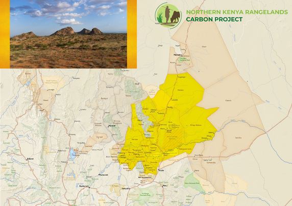
https://www.northernkenyacommunitycarbon.org/where-we-work <-- shared link to case study, Northern Kenyan Rangelands Carbon project
--
https://doi.org/10.9734/ijecc/2024/v14i74265 <-- shared paper
--
#GIS #spatial #mapping #carboncredit #carboncreditmarket #Kenya #NorthernKenyaRangelands #CarbonProject #rangelands #geoethics #bloodcarbon #EthicalGEO #carbonsequestration #spatialanalysis #ethics #ethical #grassland #communityconsent #businessinterests #economics #business #transparency #indigenous #landrights #localcommunities # #commodity #commoditisation #ecology #ecosystems #management #planning
--
https://ethicalgeo.org/ecosystem-mapping-for-carbon-credit-schemes/ <-- shared technical article
--
https://www.northernkenyacommunitycarbon.org/where-we-work <-- shared link to case study, Northern Kenyan Rangelands Carbon project
--
https://doi.org/10.9734/ijecc/2024/v14i74265 <-- shared paper
--
#GIS #spatial #mapping #carboncredit #carboncreditmarket #Kenya #NorthernKenyaRangelands #CarbonProject #rangelands #geoethics #bloodcarbon #EthicalGEO #carbonsequestration #spatialanalysis #ethics #ethical #grassland #communityconsent #businessinterests #economics #business #transparency #indigenous #landrights #localcommunities # #commodity #commoditisation #ecology #ecosystems #management #planning

Ecosystem Mapping for Carbon Credit Schemes | EthicalGEO
Introduction Geospatial Information Systems (GIS) have become central to the growth of carbon credit markets. Remote sensing and other GIS approaches enable detailed measurement, monitoring, and verification of carbon sequestration projects worldwide (Dossa and Miassi, 2024). However, with this influential role comes significant ethical responsibility. In this blog, we critically explore how GIS technologies are ...