๐Ÿš€ EO-Tools 2025.4.0 is out!

๐ŸŒ New in this release:
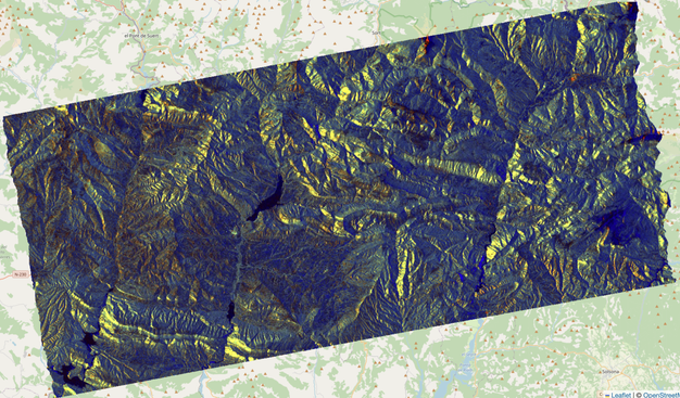
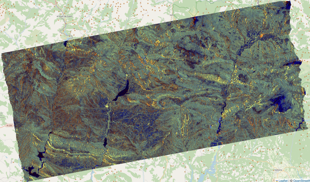
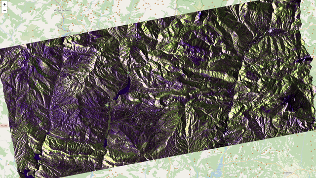
- Support for Sentinel-1C products!
- H-Alpha dual-pol decomposition from SLCs ๐Ÿ›ฐ๏ธ

๐Ÿ“˜ Dive in: https://eo-tools.readthedocs.io
๐Ÿ’ป Code: https://github.com/odhondt/eo_tools

#EO_tools #RemoteSensing #Sentinel1 #SAR #EarthObservation #OpenSource #Python #Dask #Xarray

eo-tools documentation

El poder i detall de les tรจcniques de teleobservaciรณ de la terra em flipa molt.

https://framapiaf.org/@tyldurd/114359605408260967
Here's a polarimetric color composite of a Sentinel-1C image processed with EO-Tools โ€” shown both without and with terrain flattening. It's fascinating how much information is hidden by topography.

I'm thinking of adding compositing functions directly into the software. What do you think โ€” would that be useful?

#eo_tools #Python #EarthObservation #RemoteSensing #OpenSource #Sentinel1C

Olivier D'Hondt ๐Ÿ›ฐ๏ธ๐ŸŒ๐ŸŒฑ (@[email protected])

Attachรฉโ€ฏ: 2 images Here's a polarimetric color composite of a Sentinel-1C image processed with EO-Tools โ€” shown both without and with terrain flattening. It's fascinating how much information is hidden by topography. I'm thinking of adding compositing functions directly into the software. What do you think โ€” would that be useful? #eo_tools #Python #EarthObservation #RemoteSensing #OpenSource #Sentinel1C

Framapiaf

Here's a polarimetric color composite of a Sentinel-1C image processed with EO-Tools โ€” shown both without and with terrain flattening. It's fascinating how much information is hidden by topography.

I'm thinking of adding compositing functions directly into the software. What do you think โ€” would that be useful?

#eo_tools #Python #EarthObservation #RemoteSensing #OpenSource #Sentinel1C

It's hard to get proper visualizations of SAR imagery due to high image dynamics. I have spent quite some time tweaking this one, which represents the parameters of the dual-pol H-alpha decomposition on the new Sentinel-1C sensor! Disclaimer: it's visually compelling, but probably not physically accurate. :)
#Sentinel1 #eo_tools #SyntheticApertureRadar #EarthObservation #python #RemoteSensing
Finally found some time to work on implementing the famous Cloude-Pottier H-alpha polarimetric decomposition for Sentinel-1. Hopefully I can release it soon! #eo_tools #python #OpenSource #RemoteSensing #EarthObservation #SyntheticApertureRadar

๐Ÿš€ EO-Tools 2025.1.1 is out!

Users can now choose one of SRTM, ALOS-World3D, Copernicus 30m and 90m DEMs in both Sentinel-1 InSAR and SLC processors.

๐Ÿ’ป GitHub: https://github.com/odhondt/eo_tools

#eo_tools #RemoteSensing #EarthObservation #SyntheticApertureRadar #python #FOSS #InSAR

GitHub - odhondt/eo_tools: A python toolbox for easily searching, downloading & processing remote sensing imagery from various public sources. Includes a Sentinel-1 InSAR processor.

A python toolbox for easily searching, downloading & processing remote sensing imagery from various public sources. Includes a Sentinel-1 InSAR processor. - odhondt/eo_tools

GitHub

I have just released a new build to version 2025.0.1 which fixes a bug in the shadow detector that may cause a kernel crash. It should be available in the conda-forge channel in the next few hours (time for their CI/CE bot to rescan the database).

#eo_tools #EarthObservation #RemoteSensing #SyntheticApertureRadar

In progress: I have adapted my SLC and InSAR processors to work with auto-downloaded Copernicus and ALOS DEMs. I will release a new version soon. I am also thinking of handling external DEMs.

#eo_tools #RemoteSensing #EarthObservation #Geospatial

๐Ÿš€ EO-Tools 2025.1.0 "Happy New Year" edition is out!

๐ŸŽ‰ Exciting new capability: terrain correction can now be applied in the SLC processor by choosing cal_type="terrain".

๐Ÿ“– Check out the example notebook:
https://eo-tools.readthedocs.io/en/latest/s1-easy-terrain-flattening/

Give it a try and let me know how it works for you! ๐ŸŒ๐Ÿ›ฐ๏ธ

๐Ÿ’ป GitHub repo: https://github.com/odhondt/eo_tools

#eo_tools #RemoteSensing #EarthObservation #SyntheticApertureRadar #python #FOSS

Geocode & apply terrain normalization to Sentinel-1 SLC products - eo-tools documentation

Testing my terrain flattening algorithm on Mont Blanc.

#eo_tools
#EarthObservation
#SAR
#RemoteSensing
#python
#foss