#eochat #landdegradation #LDN #SDG15 #geospatial

If you are involved in land process monitoring, particularly about the degradation of land or the change in land covers, then please consider completing this survey related to the #GEO-LDN toolbox: https://forms.gle/e2xx65o9Xa9T3xkY9

GEO-LDN Toolbox Surveys

The following survey is designed for users of, and tool providers to, the GEO-LDN Toolbox. The GEO-LDN Toolbox is a curated entry point to help users select the right analytic tools and methods for monitoring land degradation and planning restoration. The purpose of the survey is to gather feedback on the utility and development needs for the GEO-LDN Toolbox, as well as understanding more about awareness of the Toolbox. The answers you give here will help GEO-LDN understand how to take the Toolbox forward. Note: The GEO Land Degradation Neutrality Flagship (GEO-LDN) is a stakeholder-driven initiative that brings together Earth observation data providers and governments to develop minimum data quality standards, analytical tools and capacity building needed to strengthen land degradation monitoring and reporting, using remote sensing and data collected on site. The LDN Toolbox is a user-oriented entry point to a suite of analytical tools, datasets and methods for land use planning towards land degradation neutrality.

Google Docs
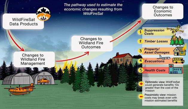
Do you think you have some knowledge in Earth Observation? Would you like to share it?
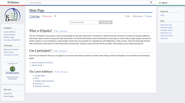
#EOpedia is the place you can do so. You can show your expertise and help others to educate themself. https://www.eopedia.org
#eoobs #community #remotesensing #eochat

Experiment with the super-resolution of Sentinel-2 data using the tool developed as part of the @EvoLandEU project!

https://lucaslongour.org/posts/2024-10-19-super-resolution-sentinel-2-for-osm/

#GISchat #EOChat

Filling the Imagery Gap in OSM: Super-Resolution Sentinel-2 Meets Outdated High-Res Imagery – Lucas Longour

Producing Super-Resolution Images to Enhance Mapping

Lucas Longour

How's it going everyone? If you have 10 minutes to spare this weekend, my co-founder Julia Wagemann and I would be super-grateful if you could share your experiences in keeping up with #geospatial data & tech via a short survey: https://forms.gle/fgRy46P233Xb9wAL7

We're taking part in an early stage startup program and are conducting this survey in order to develop a solution and also to use in our final pitch.

Thanks so much! #eochat #gischat #earthobservation #remotesensing #SatelliteData

Learning New Skills in EO & Geospatial

Hi, we are thriveGEO, a training and education startup in the Earth Observation (EO) and geospatial domain and we are running a short survey to learn better from you how you currently look for EO & geospatial information and how you make sure to keep up to date with the fast-paced landscape of EO & geospatial data and technologies. This survey is for professionals who are either working or interested in working with EO & geospatial data. The survey should take no longer than 5 to 8 minutes to complete. We are using this information to design new training solutions that will help you and your team get the information and skills you need more easily, in a shorter time. As a thank you, if you leave your email address, we will give you early access to our upcoming solution suite! - Julia Wagemann & Sabrina Szeto ([email protected])

Google Docs

New paper! Hope et al. 2024 examines the per-country access of publicly available #fire monitoring web portals like #NASAFIRMS, #GWIS, & #EFFIS compared with socio-environmental variables to analyze global usage trends over time!🌲🔥🛰️ #EOChat

🔗 https://doi.org/10.1080/17538947.2024.2420821

This work was done as part of the CEOS Working Group on Disasters Wildfire Pilot program. Learn more here: https://ceos.org/ourwork/workinggroups/disasters/wgdisasters-activities/wildfire-pilot/

✨Check it out! The newest quarterly #WildFireSat mission @NRCan @GLFC_CFS e-bulletin was published, summarizing the Cost-Benefit analysis and active #fire products under development.🔥🛰️🌲#EOChat

Use the link to subscribe or to view past e-bulletins!🔗: https://natural-resources.canada.ca/our-natural-resources/forests/wildland-fires-insects-disturbances/forest-fires/wildfiresat-e-bulletin/25643

WildFireSat e-Bulletin


I spent last week with the UBC IRSS lab (https://irsslab.forestry.ubc.ca) on their annual retreat learning about their exceptional research and sharing mine. It was a highlight of my summer and an honor to be invited to attend. #EOChat

✨ I left the retreat exhausted, of course, but also inspired by everyone’s work. I also was reminded of the importance of celebrating each other in science, the UBC IRSS lab is amazing at that! Thank you all for welcoming me into your lab for the week! 😎🛰️🌲

Integrated Remote Sensing Studio | IRSS Lab | UBC Forestry

Integrated Remote Sensing Studio

Interested in collaboration, Earth observations, and wildfire monitoring? Please consider submitting to our awesome session B002 at #AGU2024! #EOChat

This session will feature invited talks from Ane Alencar and Susan Prichard!

More info:
https://agu.confex.com/agu/agu24/prelim.cgi/Session/226036

Advancements in Wildland Fire Management and Engagement: Integrating Earth Observation Technologies and Open Collaborative Development

Wildland fires pose significant challenges to communities, ecosystems, and economies worldwide. Balancing their negative impacts with their positive benefits requires innovative approaches that leverage cutting-edge technologies while fostering collaboration among diverse stakeholders. This session proposes a comprehensive exploration of advancements in wildland fire management, monitoring, and modeling by integrating Earth observation technologies and collaborative development efforts. We will highlight innovative approaches that foster cross-boundary, multi-jurisdictional collaborations among tribal, local, federal, and international partners. For example, efforts like Canada’s WildFireSat mission, NASA FireSense, the Pyregence Consortium, and the internationally funded GOFC-GOLD Fire Mapping and Monitoring Implementation Team are creating transformative wildland fire science, data products, and tools built on relationships and knowledge exchange. By bringing together diverse perspectives and expertise, we aim to advance the science and practice of wildland fire management while enhancing the resilience of communities and ecosystems in the face of increasing wildfire risk and lengthening fire seasons.

AGU - AGU24

Please consider submitting to our #AGU2024 session SY033 "Innovative Applications of Social Sciences to Advance Earth Observations and Remote Sensing"! #EOChat

This session will feature invited presentations from Ufuoma Ovienmhada of MIT & Michelle Stuhlmacher of DePaul!

More info here:
https://agu.confex.com/agu/agu24/prelim.cgi/Session/227542

Innovative Applications of Social Sciences to Advance Earth Observations and Remote Sensing

Join us for an engaging session that explores the intersection of Earth observation (EO) and social science for tackling pressing global challenges. Earth observations are used to monitor climate change, advance sustainable development goals, and inform policy decisions. Social science in EO enables transformative research by providing crucial insights into human dimensions of environmental issues, such as understanding human behavior and perspectives, identifying barriers and opportunities, assessing impacts and equity, enhancing collaboration and co-design, and more. This session will highlight the diverse methodologies of applied social sciences, from mixed methods to transdisciplinary approaches, their integration with EO applications and research, and opportunities to improve the effectiveness and quality of these methods. Through discussions on varying methods and applications of social sciences in EO, we strive to uncover how these approaches enhance transformative research while addressing societal and environmental challenges.

AGU - AGU24
Transitioning Seamlessly: CDSE JupyterLab for Former MS Planetary Computer Hub Users

Copernicus Data Space Ecosystem - Europe's eyes on Earth

Copernicus Data Space Ecosystem