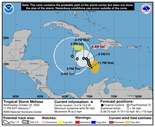
Update on #TropicalStorm #Melissa .... winds are still at 50mph but rapid strengthening is expected this weekend, with forecast to be a #cat4 #hurricane by Sunday.
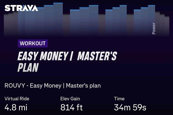
An easy #Rouvy workout. First one in the "Masters" plan.
It was on a mainly uphill #cat4 route, so the distance is a bit low. Really enjoyed it when we did start descending... I could almost feel the wind on my scalp!
https://www.youtube.com/watch?v=68T8etedYfI
Hope any of my peeps living in Florida have either gotten out or has the best of builds where they live.
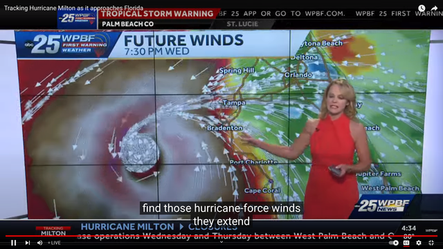
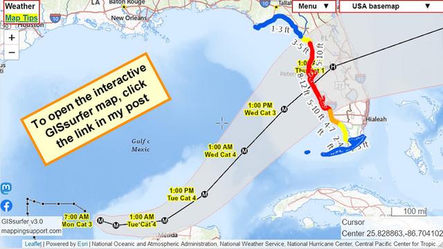
Hurricane Milton off the coast. Be safe. Here's some live local news covering it. Take care.
#Hurricane #Milton #Cat5 #StormSurge #Cat4 #TropicalCyclone #Florida #Tampa #Live #News #Breaking #Flooding #Cyclone #PalmBeach #Okeechobee #Helene #Orlando #Sarasota #VeroBeach #Daytona #Floods #Georgia #GulfOfMexico #StormSurge #Bradenton #PalmBay #Cuba #CapeCoral #Arcadia

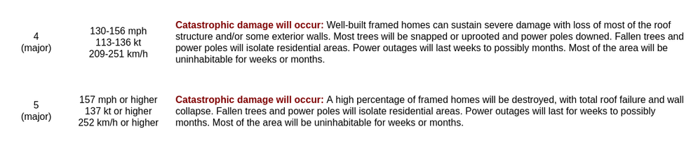
Saffir Simpson definitions for CAT4 and CAT5 (remember, this is only wind damage -- NOT surge damage, and not extreme rainfall/flooding)
10/7/24 805A CDT Update for Hurricane Milton
...MILTON RAPIDLY INTENSIFIES INTO A CATEGORY 4 HURRICANE...
Data from both Hurricane Hunter aircraft indicate that Milton has
strengthened to a category 4 hurricane. The maximum sustained winds are estimated to be 150 mph (240 km/h). Milton is a category 4 hurricane on the Saffir-Simpson Hurricane Wind Scale. Data from the aircraft also indicate that the minimum pressure has fallen to 940 mb (27.76 inches).
#HurricaneMilton is now at #Category3 strength. NOAA is currently forecasting it will increase in strength to #Category4 before dropping back to category 3 before landfall. Of course that could change.
#FLwx #Cat3 #Cat4
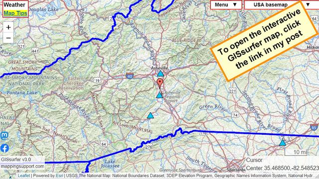
Blue symbols are just some of the streamgages where major flooding is expected in the western part of North Carolina. At the gage below the red marker the prior record water level will be blown away by an additional 10 feet of water height! 😬
Click a blue marker and follow the link in the popup.
#Helene #HurricaneHelene #Hurricane #NCwx #Cat4

NHC:
"Hurricane Helene Tropical Cyclone Update
NWS National Hurricane Center Miami FL AL092024
620 PM EDT Thu Sep 26 2024
...HELENE NOW AN EXTREMELY DANGEROUS CATEGORY 4 HURRICANE...
A NOAA Hurricane Hunter aircraft currently investigating Helene
recently found that the maximum sustained winds have increased to 130 mph (215 km/h). The minimum central pressure has also decreased
to 947 mb (27.96 inches) based on dropsonde data."
https://mesonet.agron.iastate.edu/wx/afos/p.php?pil=TCUAT4&e=202409262220

Hurricane Helene
NHC: ...HELENE NOW AN EXTREMELY DANGEROUS CATEGORY 4 HURRICANE...

