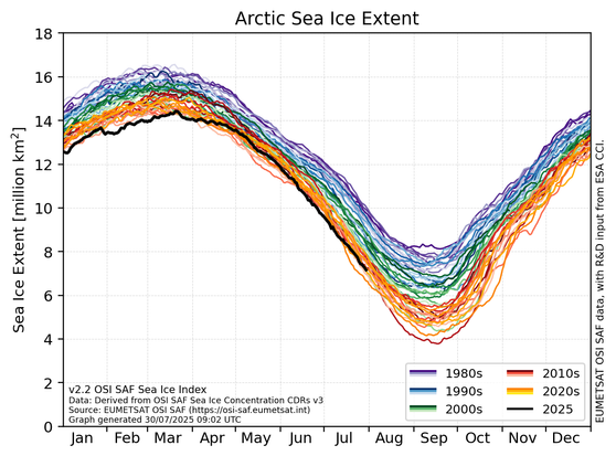
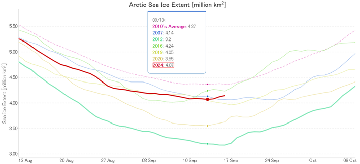
#SSMIS data-end grows close.

Our #SeaIce team has been busy this summer to ensure product continuity.

Our Sea Ice Index will be updated from v2.2 (SSMIS based) to v2.3 ( #AMSR2 based) from Friday 01/08/2025 on, but access to it will remain unchanged, ensuring a straightforward transition.

More on this: https://osi-saf.eumetsat.int/community/list-of-service-messages/impact-loss-ssmis-data-osi-saf-sea-ice-index

For information about our other SSMIS products: https://osi-saf.eumetsat.int/community/stories/implications-end-ssmis-data-osi-saf-products

#climate #arctic #antarctic

It now looks highly likely that the 2024 #Arctic #SeaIce minimum extent will prove to be 4.07 million km² on September 13th, using
#JAXA #AMSR2 data:

https://GreatWhiteCon.info/2024/09/facts-about-the-arctic-in-september-2024/#Sep-17

That is 4th lowest for the date, but the equal 5th lowest daily minimum in the satellite era:

Facts About the Arctic in September 2024 | The Great White Con

Marina Durán Moro (MET Norway) carries assimilation of Level2 #SeaIce Concentration from #AMSR2 : from each orbit individually.

This performs better than assimilating daily average products, but there are regional dependency.

#IICWGDA11 #SeaIceDataAssimilation

Jozef Rusin (PhD candidate at MET Norway and UiT) presents his research on Resolution Enhanced #SeaIceConcentration from #AMSR2 at #IICWGDA11.
New Record Antarctic Sea Ice Minimum Extent | The Great White Con

The Alfred Wegener Institute's #AMSR2 based flavour of #Antarctic #SeaIce extent has also posted a new satellite era minimum.

2/n

Cc: @seaice @Ruth_Mottram @sellathechemist @kevpluck @ZLabe

#Arctic #SeaIce extent has been growing fast over the last 3 days, mostly in the Hudson Bay and Chukchi Sea.

Here is an animation of #SeaIce concentration coverage from the Japanese #satellite #AMSR2, processed by yours truly et al 😜.

Have a nice week-end when the time comes!

Drift of iceberg A76 from August to December 2022 observed with #AMSR2 satellite data. Animation in near-sided perspective from 150 km height.

#Iceberg #A76 calved from the Ronne Ice Shelf in May 2021. It is about 170 km long and 25 km wide and weighs about 1000 Gt.

https://www.nature.com/articles/s41586-022-05037-w

#Antarctica #SeaIce @antarctica

Antarctic calving loss rivals ice-shelf thinning - Nature

Data from multiple satellite sensors show that Antarctica lost almost 37,000 km2 of ice-shelf area from 1997 to 2021, and that calving losses are as important as ice-shelf thinning.

Nature