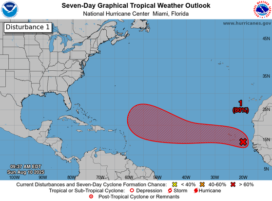
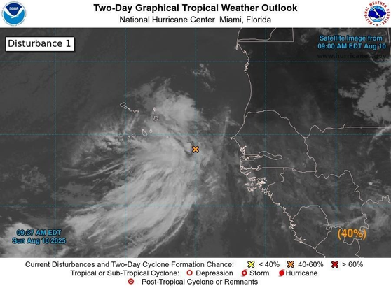
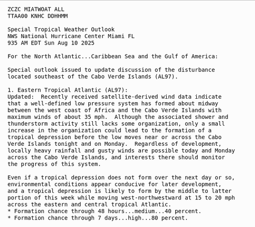
8am EDT Monday 11 Aug -- NHC is currently monitoring 3⃣ features in the Atlantic Basin this morning. Of these, the system just west of the Cabo Verde Islands (#AL97) has a high chance (90% 🔴) of becoming a tropical cyclone over the next couple of days. hurricanes.gov https://x.com/NHC_Atlantic/status/1954876441973477458

I keep NOT liking this one.

Where it is, the way it's shaping. It's very unlikely to hit Fla shores, buuuuuuut I am twitching.

Remember NOAA is a Common good, an amazing, quasi miraculous system of assets and experts monitoring weather to protect us, not only US but about half of the Earth, and the #MAGAts #GOP wants to destroy it to fill their pockets.

#Florida #Weather #TD1 #AL97 #NOAA #NHC

#weather #GulfOfMexico #Caribbean #Mexico #Cuba #NHC #NOAA

#TropicalDisturbance1 #AL97 now has a 90% chance of becoming a tropical cyclone within the next 48hrs.

The system has coalesced into a stronger TD, and it's looking ever more likely that it will organize enough to reach cyclone status. The hashed area of probability of being affected y storm has veered NE-ward, and seems to go through Cuba. If the storm becomes any stronger than a high end Tropical Storm, it WILL reach SW #Florida.

See
https://www.star.nesdis.noaa.gov/GOES/sector_band.php?sat=G16&sector=car&band=GEOCOLOR&length=24

GOES-19 - Sector view: Caribbean - GeoColor - NOAA / NESDIS / STAR

Near real-time publication of GOES-East and GOES-West images from NOAA/NESDIS/STAR

GOES Image Viewer - NOAA/NESDIS/STAR website
@NHC_Atlantic: RT by @NWSAtlanta: 1am CDT Monday 23rd Sep Key Messages for system in NW Caribbean (#AL97). Watches or warnings could be required for portions of the Yucatan Peninsula or Western Cuba later today. Interests in the #Florida Panhandle & west Florida coast should monitor closely.… https://twitter.com/NHC_Atlantic/status/1838106085242425811
National Hurricane Center (@NHC_Atlantic) on X

1am CDT Monday 23rd Sep Key Messages for system in NW Caribbean (#AL97). Watches or warnings could be required for portions of the Yucatan Peninsula or Western Cuba later today. Interests in the #Florida Panhandle & west Florida coast should monitor closely.

X (formerly Twitter)
@NHC_Atlantic: 1am CDT Monday 23rd Sep Key Messages for system in NW Caribbean (#AL97). Watches or warnings could be required for portions of the Yucatan Peninsula or Western Cuba later today. Interests in the #Florida Panhandle & west Florida coast should monitor closely. https://twitter.com/NHC_Atlantic/status/1838106085242425811
National Hurricane Center (@NHC_Atlantic) on X

1am CDT Monday 23rd Sep Key Messages for system in NW Caribbean (#AL97). Watches or warnings could be required for portions of the Yucatan Peninsula or Western Cuba later today. Interests in the #Florida Panhandle & west Florida coast should monitor closely.

X (formerly Twitter)

Pity #Bermuda

They are just getting out of the vortex of a Cat2 remainder, #Lee, and next week will face another potential Cat2 hurricane, when Tropical Depression 15 turns into a cyclone.

#TD15 #AL97