NWS Atlanta Bot

@NWSATLBOT
23 Followers
0 Following
3.6K Posts

This account reposts the NWS Atlanta Twitter feed so that I can see those posts without going to that cursed website.

COMPLETELY UNOFFICIAL

Made by @MrMcNamerica using echofeed.app

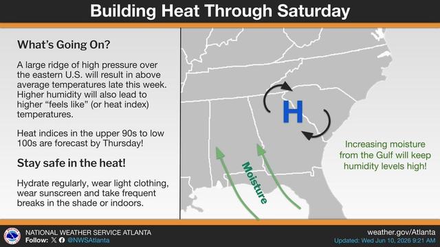
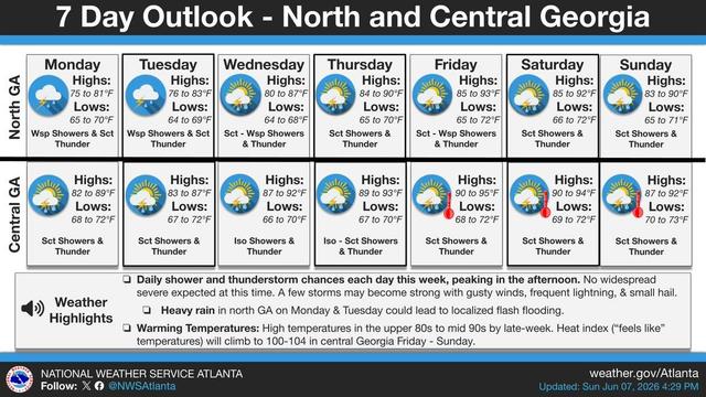
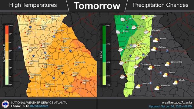
Rising temps and heat indices are in the forecast late this week. Heat index values in the upper 90s to low 100s are forecast by Thursday across parts of Central GA. Keep an eye on the forecast especially if you're planning on spending an extended amount of time outdoors! #gawx https://x.com/NWSAtlanta/status/2064804569952006529
Flash Flood Warning including Cedartown GA and Cave Spring GA until 12:00 AM EDT https://x.com/NWSAtlanta/status/2064513079317037329
Showers and T-Storms moving out of TN and into northern AL/GA. These storms have a history of severe/damaging wind gusts, however they have been weakening as they approach the border. The main concern will be gusty winds and heavy rainfall as they move into the state. #GAWX https://x.com/NWSAtlanta/status/2064505122038624656
Flash Flood Warning including Summerville GA and Trion GA until 10:45 PM EDT https://x.com/NWSAtlanta/status/2064146554034778605
Flash Flood Warning continues for Summerville GA and Trion GA until 10:45 PM EDT https://x.com/NWSAtlanta/status/2064149801814441991
Flash Flood Warning including Henderson GA until 10:15 PM EDT https://x.com/NWSAtlanta/status/2064137791898853858
A flood watch is in effect until 9pm this evening for northwest GA. While the threat is conditional, rainfall rates up to 2-3" per hour and slow-moving showers/t-storms may lead to flash flooding. Stay up to date on current conditions at http://weather.gov/ffc #gawx https://x.com/NWSAtlanta/status/2063953288580436255
The week ahead will be characterized by warming temperatures and daytime showers and thunderstorms. The greatest precipitation coverage is forecast across north GA on Monday and Tuesday. Late in the week, heat index values could climb into the 100s in central GA. #gawx https://x.com/NWSAtlanta/status/2063735660536570098
Heavy rainfall will be possible for north (and portions of central) Georgia through Tomorrow, which could lead to flooding risk. Rainfall rates may exceed 2"-3" in some areas , though coverage of the heaviest rain will likely be spotty. #gawx https://x.com/NWSAtlanta/status/2063704907769655698
After a brief stretch of drier weather, rain chances return to our area tomorrow (Sunday). Showers and thunderstorms will be most likely in northwest Georgia in the afternoon. Storms will produce lightning and periods of heavy rain but are not expected to be severe. #gawx https://x.com/NWSAtlanta/status/2063427367448547802