See
https://www.star.nesdis.noaa.gov/GOES/sector_band.php?sat=G16§or=gm&band=GEOCOLOR&length=24
For overall movement and development of the system in the past couple of hours.
#weather #GulfOfMexico #Mexico #Guatemala #Belize #NHC #NOAA
#AL95 is now #TropicalDepression15, and retains potential to become #TropicalCyclone15. For now, likelihood of Tropical Storm winds, up to 34-35mph sustained.
Core remains as per last report. Organized, but not at TC level. Winds growing steadily stronger as it approaches coast.
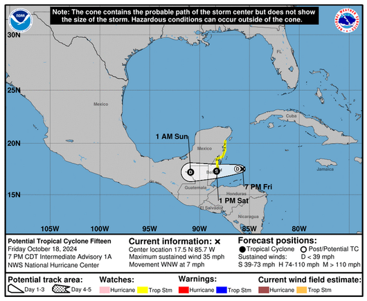
System vortex has coalesced in the area near coast of Belize, Guatemala and Mexico.
Core of the storm should arrive Saturday mid day. Slow moving system at about 8-9mph, due West.
Good chance of NOT becoming a Tropical Cyclone, if it remains with present course, speed. Landfall and climbing onto continental shelf will drain some of the energy of the system.
#weather #GulfOfMexico #Guatemala #Mexico #NHC #NOAA
#AL95 has an increased chance (70%) of becoming a tropical cyclone within the next 48hrs.
Its core has become more defined, and the whole system is coalescing into a tropical storm, fast. A incipient vortex is manifesting, with a visually defined core, getting better organized by the hour.
Some of AL95's outer edge bands are reaching over #Cuba, and even into South #Florida and #Keys, bringing intermittent rain.
Each time you open this interactive #GIS map you will see the latest information for this storm. On Thursday this storm is expected to designated #HurricaneLee. By Sunday it is forecast to be a category 4 #hurricane.
#TropicalStormLee #AL95