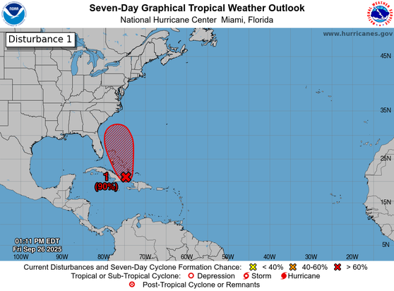
2 pm EDT - A low pressure system #94L appears to be forming near eastern Cuba and the southeastern Bahamas. Gradual development of this system is expected, and it will likely become a tropical depression during the next day or so while it moves across the central and northwestern Bahamas. Tropical storm watches or warnings could be required for portions of the Bahamas and advisories on a potential tropical cyclone could be issued as early as later today. Visit http://hurr https://x.com/NHC_Atlantic/status/1971628101823029569
8 am EDT - Showers and thunderstorms continue to show signs of organization in association with a tropical wave #94L located near Hispaniola and eastern Cuba. This low is expected to become a tropical depression near the central and northwest Bahamas over the weekend. Heavy rains are likely to spread across the Bahamas and eastern Cuba during the next day or two. While there remains considerable uncertainty in the long-range track and intensity of the system, there is a s https://x.com/NHC_Atlantic/status/1971541756819669011

Could #Humberto prevent future #Imelda from making landfall over the U.S.? 🤔

Invest #94L is likely to develop into Imelda, which could track toward the U.S. East Coast. But, if Humberto gets close enough, its influence could pull Imelda away, avoiding a U.S. landfall.

"An exceedingly complex forecast lies ahead for #Humberto and #94L. Of the latter, the Nat'l Hurricane Center warns that "the chances of wind, rainfall, and storm surge impacts for a portion of the southeast U.S. coast are increasing.” Full scoop here:" - Meteorologist and journalist Bob Henson in #YaleClimateConnections

https://yaleclimateconnections.org/2025/09/gabrielle-heads-for-azores-while-humberto-and-94l-brew-in-nw-atlantic/

Gabrielle heads for Azores while Humberto and 94L brew in NW Atlantic

Unusually warm waters are fueling a busy few days near the peak of hurricane season.

Yale Climate Connections
8 am EDT - In addition to #Humberto and #Gabrielle, NHC continues to monitor #94L located near the Dominican Republic. This system has a chance of becoming a tropical depression in the vicinity of the central and northwest Bahamas during the next couple of days. Interests in the southeast U.S., and the Bahamas should monitor its progress. http://hurricanes.gov https://x.com/NHC_Atlantic/status/1971178876110811222
8 am EDT - There is high chance of a tropical depression forming over the central Atlantic later this week #93L and a medium chance of a tropical depression forming over the southwestern Atlantic in a few days #94L. For more information, visit https://x.com/NHC_Atlantic/status/1970454851197849794
8pm EDT 20 July: NHC is watching a small area of low pressure (Invest #94L) in the Central Tropical Atlantic. This system has a low chance (20% 🟡) of becoming a tropical cyclone before moving into less favorable environmental conditions. Latest outlook: hurricanes.gov/gtwo.php?basin… https://x.com/NHC_Atlantic/status/1947078432388497447

Low pressure area #94L this morning north of the Dominican Republic. This system has a very high chance (90%) of becoming a tropical depression or storm within the next couple of days.

#Invest94L #weather #WX

Intensity forecasts (take with a shaker full of salt) #94L #hurricane
94L out there in the Atlantic. #94L #TropicalWx #Tropics #hurricanes