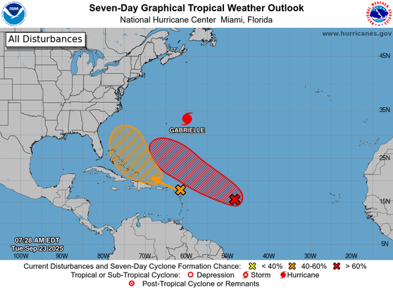
8 am EDT - There is high chance of a tropical depression forming over the central Atlantic later this week #93L and a medium chance of a tropical depression forming over the southwestern Atlantic in a few days #94L. For more information, visit https://x.com/NHC_Atlantic/status/1970454851197849794
2pm 7/16: A low pressure area (Invest #93L) located near the coast of the Florida Panhandle is forecast to move westward to near the southeast coast of Louisiana on Thursday. Environmental conditions are generally favorable for some development, and a tropical depression could… https://x.com/NHC_Atlantic/status/1945541360825897420
8pm 7/15: A low pressure area (Invest #93L) could emerge over the far northeastern & north-central Gulf, approaching Louisiana on Thursday as it moves westward. Environmental conditions over the Gulf are generally favorable, and a tropical depression could form if the system… https://x.com/NHC_Atlantic/status/1945263919758492043

Here’s Invest #93L over the past few days as it nears #Florida.

The system will cross the Florida Peninsula today, with heavy rain possibly causing flash flooding. Later this week, it could become a tropical depression and bring flooding to parts of the north-central Gulf Coast.

8pm EDT July 14: An area of low pressure off the east Florida Peninsula coast (Invest #93L) now has a medium chance (30%🟡2-day / 40%🟠7-day) of becoming a tropical cyclone as it moves westward into northeastern portion of the Gulf. Regardless of formation, heavy rainfall could… https://x.com/NHC_Atlantic/status/1944906684029075457

Invest #93L has been designated northeast of the Bahamas. It has a low chance of development in the next 7 days.

Latest details here: https://zoom.earth/storms/93l-2024/?date=2024-10-09

Invest 93L LIVE Tracker, Updates & Forecast | Zoom Earth

Live tracking map, satellite images and forecasts of Invest 93L northeast of the Bahamas. Low chance of development. Current wind speed 45mph.

Zoom Earth

Invest #93L has been designated near the Cabo Verde Islands.

See the latest details here: https://zoom.earth/storms/93l-2024/?date=2024-09-10

Invest 93L LIVE Tracker, Updates & Forecast | Zoom Earth

Live tracking map, satellite images and forecasts of Invest 93L northeast of the Bahamas. Low chance of development. Current wind speed 45mph.

Zoom Earth

Invest #93L has been designated in the Bay of Campeche. It has a medium chance of organizing into a tropical depression in the next 7 days.

Get the latest updates here: https://zoom.earth/storms/93l-2024/?date=2024-06-22

Invest 93L LIVE Tracker, Updates & Forecast | Zoom Earth

Live tracking map, satellite images and forecasts of Invest 93L northeast of the Bahamas. Low chance of development. Current wind speed 45mph.

Zoom Earth
Moisture from Tropical Storm #Max and #Lidia entering Mexico from the Eastern Pacific and invest #93L in Southwest Gulf of Mexico / Bay of Campeche should bring moisture chances along the immediate US Gulf coast and into the Southeastern US this week. 9Oct2023

Invest #93L has been designated in the Bay of Campeche near Mexico. It has a low chance of development in the next 7 days.

See the latest details here: https://zoom.earth/storms/93l-2023/?date=2023-10-09

Invest 93L LIVE Tracker, Updates & Forecast | Zoom Earth

Live tracking map, satellite images and forecasts of Invest 93L in the Bay of Campeche. Low chance of development. Current wind speed 30mph. Max 15mph.

Zoom Earth