@osm_to

21 Followers
16 Following
35 Posts

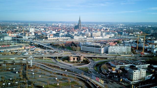
Das neue Jahr war noch keinen Tag alt, da sind schon die ersten Drohnenaufnahmen des Jahres von uns auf Wikimedia Commons gelandet.
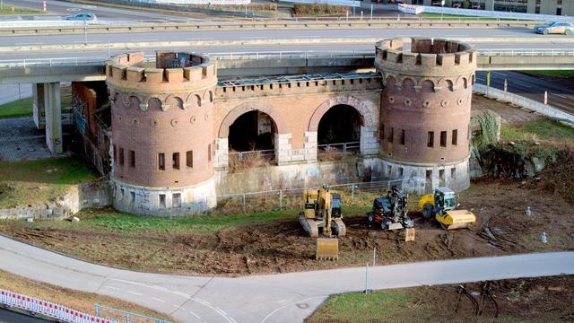
Am Blaubeurer Tor wird – wie an vielen Stellen der Doppelstadt – ordentlich umgebaut. Umso wichtiger, die Geschichte festzuhalten und unter Freier Lizenz zu veröffentlichen – denn so schlummern diese Zeitdokumente nicht in Archiven, sondern können von der ganzen Welt wiederverwendet werden. Nicht nur in den Wikiprojekten!

https://commons.m.wikimedia.org/wiki/Category:Drohnenfotografie_tempor%C3%A4rhaus_(2025)

Category:Drohnenfotografie temporärhaus (2025) - Wikimedia Commons

Oh neat, @openstreetmap has a new community place now made in #discourse. Testing it right now with my first post about Ground Control Points tags for @osm_to and #OpenDroneMap.
Nice, good move.

https://community.openstreetmap.org/t/how-to-use-ground-control-points-now/1729

How to use "ground control points" now?

Hi there, I would like to add “ground control points” into OSM and I do not know how the way to do that is right now. I asked this last year for the our idea of the NASA SpaceApps Challenge [0] and since then I am not sure I saw progress there. I would like to add some marks I have found in Jena and also I would like to add others like the one we proposed during the challenge[1] via OSM.to[2]. Firstly, can anyone help me how to do that? If there is no way to do that yet, I would like to ask ...

OpenStreetMap Community

My 1st @openstreetmap edit, be kind to me! :)
I added a #GroundControlPoint on the Big Spring McMahon–Wrinkle Airport that's used for #Satellite optical calibration.
My goal's to add @osm_to QR-coded GCPs to #OpenStreetMap. What do you think?
@osm_fr @SwissOSM @osmcz @sotm

https://m.youtube.com/watch?v=x3GjJ6imvHY

OpenStreetMap: how to add a ground control point (1st try)

YouTube

Let's have summer 2022 events to build some @nasa #spaceapps QR-codes together that can be seen from #space with CopernicusEU, planet and other satellites that improve #openstreetmap & #OpenDroneMap maps for all of us.
Shall we? Interested?

https://docs.google.com/spreadsheets/d/11W7_XgcpzvrSnfxLeJU6WHq02oCHtyCCMje28s3R-LM/edit?usp=sharing

Poll: https://twitter.com/osm_to/status/1535913558264905730?s=21&t=DsbAD6H83AJnw847avkJbQ

osm.to create gcp event

start Start:,This shall give you some ideads what all of this is all about. Short Story:,We worked on <a href="http://www.osm.to/">www.osm.to</a> during NASA's SpaceApps Challenge in 2021. We created QR codes that can be seen from space and satellites can scan and directly get information where ...

Google Docs

Hey #OpenDroneMap & #drone people. Would you mind have a look at our GCP-file's format? Does it work w/ ODM?😇
We couldn't test it ourselves when we worked on @osm_to during #NASA's #spaceapps challenge 2021

https://www.youtube.com/watch?v=fPPKc9Ufdzk

gcp osm

YouTube

Good morning, #SpaceApps people around the world. It‘s a lovely morning 🌞here in #Stuttgart and #Jena, where we just started the 2nd and last day of the #nasa #space #hackathon.
What are you working on in your spaceapps projects today? ☺️
@jenaertoots (delayed toot)

https://imgur.com/a/YKJvqP0#6g1YRmP

imgur.com

Imgur: The magic of the Internet

Imgur

MobModelling of the #Python Implementation of our URL-parser during #SpaceApps challenge. moormaster is now coding it.
We will have to talk about your proposed GCP feature soon, #openstreetmap :)

https://wiki.openstreetmap.org/wiki/Proposed_features/Ground_Control_Point

Proposed features/Ground Control Point - OpenStreetMap Wiki

#Hacktoberfest2021 complete, now waiting.... :)
Contributed to the #nasa #spaceapps project @osm_to and my #orbitdeterminator code for AerospaceResearch.net.
Which #OpenSource project did you help?
DJ Jim music bot for @jitsinews is entertaining us w/ the best electronic music during our #nasa #spaceapps session right now.
Join >30k people worldwide for this #opensource #hackathon. We're from #Stuttgart improving satellite & drone maps @jenaertoots https://2021.spaceappschallenge.org/challenges/statements/drones-and-satellites-for-urban-development/teams/osmto/project