I filled up my EV (300 mile range) for $20.
I filled up my gas car (350 mile range) for $65.
I filled up my gas car (350 mile range) for $65.
Global mean sea level (GMSL) update and a new study on this dataset (#OpenAccess): https://os.copernicus.org/articles/19/431/2023/
"...confirms previous analysis in the literature demonstrating that the GMSL record is accelerating"
This graphic is produced by https://aviso.altimetry.fr/en/data/products/ocean-indicators-products/mean-sea-level.html

Abstract. We present the latest release of the global mean sea level (GMSL) record produced by the French space agency Centre National d’Etudes Spatiales (CNES) and distributed on the AVISO+ website. This dataset is based on reprocessed along-track data, so-called L2P 21, of the reference missions TOPEX/Poseidon (TP) and Jason-1, Jason-2 and Jason-3. The L2P 21 CNES/AVISO+ GMSL record covers the period January 1993 to December 2021 and is now delivered with an estimate of its measurement uncertainties following the method presented in Ablain et al. (2019). Based on the latest calibration (Cal) and validation (Val) knowledge, we updated the uncertainty budget of the reference altimetry mission measurements and demonstrate that the CNES/AVISO+ GMSL record now achieves stability of performances of ± 0.3 mm yr−1 at the 90 % confidence level (C.L.) for its trend and ±0.05 mm yr−2 (90 % C.L.) for its acceleration over the 29 years of the altimetry record. Thanks to an analysis of the relative contribution of each measurement uncertainty budget contributor, i.e. the altimeter, the radiometer, the orbit determination and the geophysical corrections, we identified the current limiting factors to the GMSL monitoring stability and accuracy. We find that the radiometer wet troposphere correction (WTC) and the high-frequency errors with timescales shorter than 1 year are the major contributors to the GMSL measurement uncertainty over periods of 10 years (30 %–70 %), for both the trend and acceleration estimations. For longer periods of 20 years, the TP data quality is still a limitation, but more interestingly, the International Terrestrial Reference Frame (ITRF) realization uncertainties becomes dominant over all the other sources of uncertainty. Such a finding challenges the altimetry observing system as it is designed today and highlights clear topics of research to be explored in the future to help the altimetry community to improve the GMSL measurement accuracy and stability.
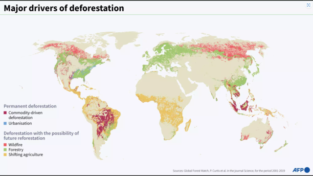
Fighting for their lives: the world's forests in figures
#ClimateEmergency #pollution #ecology #environment #ClimateCrisis #ClimateCatastrophe
#ClimateChange #Climate #forests
Satellite-derived observations of #Arctic sea ice thickness show much thinner ice currently compared to last year across the Beaufort Sea and extending into the Central Arctic. The relative thicker ice is precariously located in the Fram Strait.
I update this graphic twice per week at https://zacklabe.com/arctic-sea-ice-volumethickness/
"Averting a crisis in the West is possible, but will require killing some sacred cows. The water going to grass, swimming pools, and golf courses will have to be cut. New housing will have to be denser & much more water efficient. More than half of Colorado River water currently irrigates crops fed to animals—a lot of those crops will have to go, reducing the amount of land & water in agriculture."
Time Magazine opinion piece
https://time.com/6251464/colorado-river-crisis-climate-change/