Ingmar Nitze

202 Followers
183 Following
325 Posts

Geographer and Remote Sensing Scientist with focus a on permafrost landscape dynamics.

#EarthObservation, #bigdata, #machinelearning, #AI, #visualization, #permafrost, #datascience, #EarthEngine

Alfred Wegener Institute for Polar and Marine Research in Potsdam, Germany

Google Scholarhttps://scholar.google.com/citations?user=efPKbzUAAAAJ
Websitehttps://www.awi.de/en/about-us/organisation/staff/single-view/ingmar-nitze.html
Githubhttps://github.com/initze

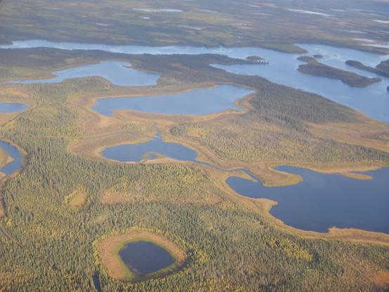
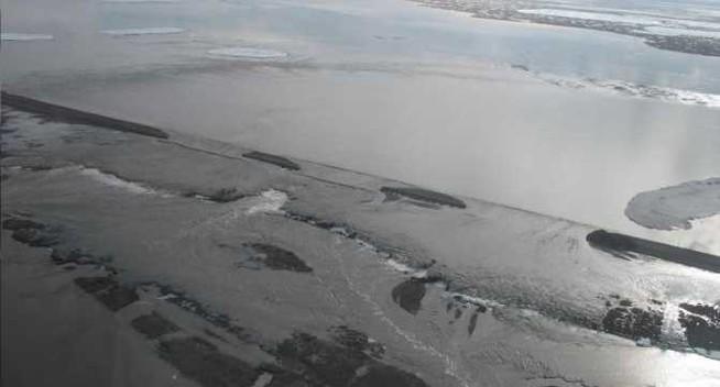
We found that #arctic #lakes emit less #methane than previously thought. High-resolution mapping shows that in the Arctic (and globally), predictions of total lake area tend to be too high. These findings better match independent measurements of atmospheric methane, which implies a greater fraction of emissions is coming from us! 😨

My latest paper describes this phenomenon in more detail and is published by the #AGU at https://doi.org/10.1029/2023GL104825

#silentsunday #germany #brandenburg #landscapephotography #winter Frozen meadows on beautiful winter day in Töplitz. 🤩❄️

Nature: The research led by Google-backed nonprofit Global Fishing Watch revealed that 75% of the world’s industrial fishing vessels are not publicly tracked. Up to 30% of transport and energy vessels also escape public tracking.

"Those blind spots could hamper global conservation efforts, the researchers say. To better protect the world’s oceans and fisheries, policymakers need a more accurate picture”

https://www.theverge.com/2024/1/3/24018797/ocean-maps-ai-satellite-imagery-radar-fishing-vessels-offshore-energy-wind-oil

#AI #cartography #dataviz

How crowded are the oceans? New maps show what flew under the radar until now

Thanks to advances in AI and satellite imagery, researchers created the most comprehensive maps yet of offshore wind energy development, fishing, and vessel traffic at sea.

The Verge
#silentsunday #photography #sunset #potsdam #moon
Beautiful sunset and moon today in Potsdam. View of the Havel river from behind the theater.

lonboard 0.3 is released, adding support for exporting to HTML and viewing inside vscode notebooks!

This is a self-contained HTML file rendering 3 million points. Iterate on your data, design a map, export to HTML and share it with a colleague.

Introducing lonboard: the fastest way to visualize large geospatial vector data from Python.

Here's 3 million points rendered with a unique color and radius per point, in two seconds.

https://developmentseed.org/blog/2023-10-23-lonboard
https://ds.io/lonboard

Launching Lonboard — Development Seed

Fast, Interactive Geospatial Data Visualization from Python.

Tree lined #road in #Potsdam in #autumn. Alexandrowka / Russian Colony.

Flooding that closed Dalton Highway also caused widespread ground sinking
[the_ad id="30587"]

The massive 2015 flooding of the Sagavanirktok River in northern Alaska had immediate impacts, including closure of the Dalton Highway for several days, but it also contributed to longer-term ground subsidence in the...
https://alaska-native-news.com/flooding-that-closed-dalton-highway-also-caused-widespread-ground-sinking/70278/
#Sagavanirktok #flooding #ground #sinking #permafrost #subsidence #dalton

Flooding that closed Dalton Highway also caused widespread ground sinking - Alaska Native News

The massive 2015 flooding of the Sagavanirktok River in northern Alaska had immediate impacts, including closure of the Dalton Highway for several days, but it also contributed to longer-term ground subsidence in the permafrost-rich region. That’s the finding by assistant professor Simon Zwieback at the University of Alaska Fairbanks Geophysical Institute in a study published […]

Alaska Native News
@g_fiske Manicougan never gets old 🤩