64 Followers
112 Following
47 Posts
#DataViz for #SciComm at USGS. Loves #maps, #rstats, and everything #svg #d3js. #QueerInSTEM they/them 🏳️‍⚧️
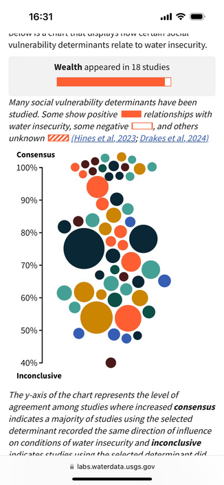
Unequal access to water: how societal factors shape vulnerability to water insecurity https://labs.waterdata.usgs.gov/visualizations/vulnerability-indicators/index.html#/en #dataviz from #USGSvizlab #water
Vulnerability Indicators

Introduction to targets: Summary and Schedule

Join conversation

Microsoft Teams
USGS Water is hiring a Tech Lead and Product Owner to support data and information delivery (GS12/13). Positions open to applicants on Monday! More info in this blog https://waterdata.usgs.gov/blog/wcb-hiring-2023/
Product Owner and Tech Lead Hiring

The USGS Web Communications Branch is hiring a Product Owner and Tech Leads (Interdisciplinary Scientists)

CA wineries
breweries in Colorado
Where are breweries, wineries, and bottled water facilities across the U.S.? Check out this interactive #dataviz looking at a new national inventory of bottled water data https://labs.waterdata.usgs.gov/visualizations/bottled-water/index.html Made with #D3 and #rstats
Water bottling across the U.S.

September #streamflow conditions across the U.S. 💧 Dry conditions persisted across much of the U.S., while parts of New England saw wet conditions. #DataViz made with #rstatshttps://github.com/DOI-USGS/flow-tiles
GitHub - DOI-USGS/flow-tiles: A tile map showing a month of streamflow conditions across the U.S.

A tile map showing a month of streamflow conditions across the U.S. - DOI-USGS/flow-tiles

GitHub
@jhollist thank you!!