Carlson Büth

32 Followers
65 Following
19 Posts
CV & Affiliationshttps://cbueth.de/

📄 New preprint! With @mzanin, we review functional network methods for transportation delay analysis + introduce #delaynet, an open-source Python package for delay propagation studies.
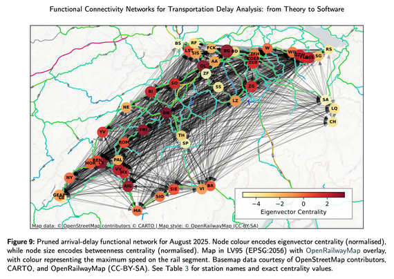
Case study: Swiss rail delays (2022-2025) using open data from SBB & opentransportdata.swiss (operated by SKI+ for BAV).

🔗 arXiv: https://arxiv.org/abs/2510.05143
💻 `pip install delaynet`
📚 Docs: https://delaynet.readthedocs.io/
⭐ Code: https://github.com/cbueth/delaynet

#Transportation #NetworkScience #OpenData #Python #RailTransport

An #OpenStreetMap  contributor wrote an item "Authoritative Data is Not More Right Just Because It’s Authoritative."

🎋 Read their @openstreetmap diary 👉🏼 https://www.openstreetmap.org/user/tordans/diary/407524.

Authoritative Data is Not More Right Just Because It’s Authoritative

HeiGIT recently published an analysis together with the German Federal Agency for Cartography and Geodesy (BKG), comparing land cover data from OSM with the official CORINE Land Cover (CLC) dataset from BKG.

OpenStreetMap
Proximity-based cities emit less mobility-driven CO2
https://arxiv.org/abs/2510.00094
Proximity-based cities emit less mobility-driven CO$_2$

In the quest for more environmentally sustainable urban areas, the concept of the 15-minute city has been proposed to encourage active mobility, primarily through walking and cycling. An urban area is considered a ``15-minute city" if every resident can access essential services within a 15-minute walk or bike ride from their home. However, there is an ongoing debate about the effectiveness of this model in reducing car usage and carbon emissions. In this study, we conduct a large-scale data-driven analysis to evaluate the impact of service proximity to homes on CO$_2$ emissions. By examining nearly 400 cities worldwide, we discover that, within the same city, areas with services located closer to residents produce less CO$_2$ emissions per capita from transportation. We establish a clear relationship between the proximity of services and CO$_2$ emissions for each city. Additionally, we quantify the potential reduction in emissions for 30 cities if they optimise the location of their services. This optimisation maintains each city's total number of services while redistributing them to ensure equal accessibility throughout the entire urban area. Our findings indicate that improving the proximity of services can significantly reduce expected urban emissions related to transportation.

arXiv.org

@mzanin and I are proud to introduce SynthATDelays, a minimalist and modular Python package designed to simulate air transport system and provide synthetic delay data under tuneable conditions. Find the article at Aerospace MDPI.

📜 Read the full paper: https://doi.org/10.3390/aerospace12100900
💻 Try it yourself: `pip install synthatdelays`
⭐ GitLab: https://gitlab.com/MZanin/synth-at-delays/

🚀 Excited to share our work with Kishor Acharya and @mzanin on making information theory more accessible!

The #infomeasure package addresses key barriers:
✅ Multiple estimators comparison
✅ Reproducible results
✅ Computational efficiency
✅ User-friendly interface

From EEG analysis to complex systems - one package, endless possibilities! 🔬

📜 https://www.nature.com/articles/s41598-025-14053-5
🔗 https://infomeasure.readthedocs.io/en/latest/
#OpenScience #InfoTheory

Carlson Büth @cbueth wins VCD Award for his Master thesis
https://nerds.itu.dk/2024/09/13/carlson-buth-wins-vcd-award-for-his-master-thesis/
Congrats! 🎉
Carlson Büth wins VCD Award for his Master thesis | NEtwoRks, Data, and Society (NERDS)

Superblockify is a new #Python package for reproducible analysis of and research into pro-active, pro-children, pro-safety, pro-accessibility and pro-play public spaces 🚶 🚲 🦽 🛝 Check it out, install it, and give it a spin here: https://buff.ly/4dG7scT #DataScience #Cities
superblockify documentation — superblockify 1.0.0 documentation

Just published in JOSS: '<code>superblockify</code>: A Python Package for Automated Generation, Visualization, and Analysis of Potential Superblocks in Cities' https://doi.org/10.21105/joss.06798
<code>superblockify</code>: A Python Package for Automated Generation, Visualization, and Analysis of Potential Superblocks in Cities

Büth et al., (2024). <code>superblockify</code>: A Python Package for Automated Generation, Visualization, and Analysis of Potential Superblocks in Cities. Journal of Open Source Software, 9(100), 6798, https://doi.org/10.21105/joss.06798

Journal of Open Source Software
@nerdsitu @cbueth @supergrobi Carlson implemented "superblockify" - a Python library for partitioning an urban street network into Superblock-like neighborhoods and for visualizing and analyzing the partition results. Try it out at: https://superblockify.city - submitted to @joss, funded by #juststreets
superblockify documentation — superblockify 1.0.0 documentation

- Concerns regarding the equitability of the lab test conditions were found as all reviewed studies used a fifty-percentile male head and body forms
- The results suggest that the shape and size of the head itself also play a key role in the protective effects of bicycle helmets