Same perspective on the same landscape, but with stream network generated by DepressionBreach and StreamExtract in #Whitebox Tools, virtually identical the r.watershed result. Part of an effort to characterize drainage networks on these landscapes and compare them to results of landscape evolution modeling
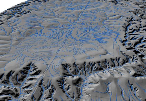
Perspective view of a loess landscape in central Nebraska, with large closed wind-eroded depressions surrounded by stream-dissected terrain. Topography from 1 m #lidar DEM. Blue lines are the stream network generated by the r.watershed tool in GRASS GIS, not entirely realistic but better than many other algorithms for this, it seems. Note effects of road embankments, ditches, and field terraces, all captured by lidar data.
Thick loess southwest of Broken Bow, Nebraska, sculpted by wind erosion and dissected by streams. Previous research shows coarse late Pleistocene loess in this region can be directly entrained by winds below the threshold for aeolian sand mobility. Troughs and narrow ridges are oriented NW-SE, typical of all large-scale deflation features in Central Plains loess. 3D perspectives created with #rayshader
Yellow River in the desert, full of water and sediment from the summer monsoon on 9/5/2022 and virtually dry on 1/3/2023. Just west of Baotou, Inner Mongolia, in the northern bend of the river. I think the whitish areas in the dry January image are areas where soluble salts have precipitated at the surface after irrigation ended for the season (common in dry regions where there's a shallow water table). Sentinel 2 image. Marker at 109.30,40.47. Zoomed out view in reply.
Yellow River delta and sediment plume, 9/5/2020, carrying sediment mobilized in the summer monsoon, including lots of eroded loess. Sentinel 2 image viewed in GEE