Northern Portugal
It’s been 19 years since we last visited Portugal—and then only Lisbon, en route to Brazil. On this occasion the camper van would give us much more access to varied landscapes and to traditional Portuguese culture. We began our exploration in the north.
Coordinates
Valença
We first saw Fortaleza de Valença from the Spanish town of Tui, across the Rio Minho | Río Miño, the Spain/ Portugal border (📷1). Fortifications were begun c. 1262 CE but greatly expanded during 17–18th C. conflicts between Spain and Portugal, with bastions, walls and moats defending two enclosed areas: the inner town or “Praça-Forte” (📷2) and the outer defensive belt or “Coroada”. The inner town is rather touristy, filled with shops and eateries (📷3). However, pastel de nata can be obtained (📷4); the consumption of these small custard tarts may be regarded as confirmation of having arrived in Portugal!
Peneda-Gerês National Park
We parked in the village of Covide on the boundary of Parque Nacional da Peneda-Gerês | Peneda-Gerês National Park, part of the UNESCO Gerês-Xures Transboundary Biosphere Reserve. We’d come to hike the PR1–Trilho da Calcedónia. As we ascended (counterclockwise to do the steeper section first/ going up) we looked over the granite terraces built into the opposite side of the valley (📷1). We’d noted these on the scenic drive inland; stone cleared from fields was used in traditional small-scale subsistence farming to create retaining walls for flat plots that resist erosion, enabling utlization of steep slopes for growing crops. On the granite slopes above Covide was a fortified hilltop settlement (“castro”) from the Iron Age. Here’s the view from the “town centre” at Ruínas da Calcedónia | Ruins of Calcedónia (📷3); archaeological remains (walls, terraces, hut traces—to trained eyes) indicate a small but well-defended Celtic-influenced community. After the Roman conquest of Iberia (2nd–1st centuries BCE) this region was integrated into the province of Lusitania; castros were abandoned, reorganized or Romanized. Local info suggests the hillfort was occupied by Romans who called it Calcedónia; they were in the vicinity, but indications of significant or sustained Roman presence seems lacking (they tended to shift settlement into more accessible valleys/ along roads). Flower of the day goes to Narcissus triandrus | Angel’s-tears, endemic to Portugal, Spain and France (📷3). As the loop trail crested the ridge we had views deeper into the park. We passed under and between gigantic boulders then began descending; the pink-flowering bushes are Erica australis | the Spanish heath, which is native to the western Iberian Peninsula and Tangier (📷4). As we returned to the village we passed a Roman granite column mile marker. A 7km/ 3h 15min loop; tiring due to attention needed to footing.
Guimarães
The centre of Guimarães, founded during 10th–12th centuries, is a UNESCO-listed World Heritage Site due to its well-preserved medieval layout and importance in Portuguese history; it’s billed as the “birthplace of Portugal” on account of links to nation building and its first king, Afonso I. Castelo de Guimarães | Guimarães Castle was initially built by Countess Mumadona in the late 10th C. likely from wood and for the purpose of protecting the monastery from attacks; its present form dates to the late 13th C. (📷1). Paço dos Duques de Bragança | Palace of the Dukes of Braganza was built c. 1420–30 CE for Afonso I, Duke of Braganza; as a large, fortress-like noble residence, it required considerable heating—as reflected in the multitude of tall conical chimneys on the roofline (📷2). Largo da Oliveira is a public square in the heart of the old town, surrounded by historic architecture and religious landmarks (📷3). In the narrow yet impeccably maintained and clean medieval streets (📷4) we found a delicious selection of cakes to bring back to the van.
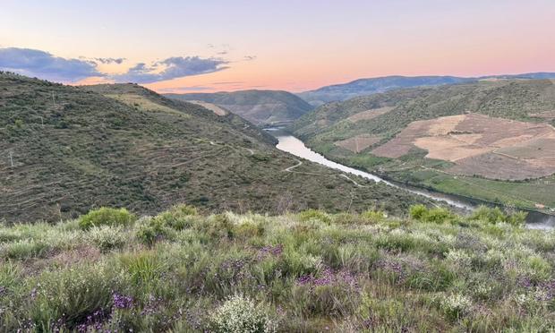
Douro Valley
The Alto Douro Wine Region is a UNESCO-listed cultural landscape that has produced wine for some 2,000 years; the region’s best known product is Port, a sweet, full-bodied fortified wine. We intersected the Rio Douro | Douro River at Mesão Frio, where we parked at a cemetery for lunch with this awesome view from the van door (📷1). Our drive continued up the Douro Valley between the towns of Peso da Régua and Pinhão, which local intel had informed us was the most scenic section (📷2&3). We came back to the river at Parque Arqueológico do Vale do Côa | Côa Valley Archaeological Park, near the town of Vila Nova de Foz Côa—still in the upper part of the wine region (📷4).
Parque Arqueológico do Vale do Côa | Côa Valley Archaeological Park, a UNESCO World Heritage Site, is home to the world’s largest concentration of open-air Palaeolithic art (1,400+ engraved rocks, although the majority are now submerged). We began in Museu do Côa | Côa Museum, which catalogues art as old as 30,000 years and displays some replicas, such as “Quinta da Barca 3” (📷1). This ibex is depicted with two head positions/ overlapping horns, indicative of artistic experimentation with frame animation to simulate movement 20–15,000 years ago! The museum’s motif (📷2) is a filiform etching (i.e. composed of thin grooves), possibly an ibex or deer, made ~12–11,000 years ago. Older examples mostly depict large animals, but people are also seen in more recent works. The in situ petroglyphs on schist canvases along the banks of the Côa River are concentrated in four main areas, to which access is permitted only via pre-booked guided tours. The site you’ll see depends on the time of day (shadows change etching visibility) and language of the tour: we were allocated to “Canada do Inferno”, accessed by 4×4 and foot. The first of ~40 engraved rocks known here was discovered (more accurately, recognised) as recently as 1991 (📷3). Rocha 1 works are 30–22,000 years old and clearly depict aurochs and a two-headed horse. Rocha 14 features the museum motif, almost invisible; it was easier to make out the front of this horse, etched using a pecking technique (📷4). We viewed two other rocks, 2 and 15, during the 2.5h tour.
Why did they do it?
Museu do Côa notes four main theories on the motivations of prehistoric artists:
Art for art’s sake: Our human ancestors created the works as a pastime and for pure aesthetic pleasure.
Sympathetic magic and fertility rites: The works, depicting prominent animal bellies and hunting weapons or wounds, and with an emphasis on human sexual characteristics, were linked to magic practices intended to ensure hunting success and human fertility.
Shamanism: Some hybrid figures have been interpreted as medicine men/ shamans and incomplete figures are seen as “emerging” from the rock; it has been proposed such works may be linked to shamanic rituals.
Woman of Piscos c. 20–25,000 years oldStructuralism and post-structuralism: The works are an organized set of signs whereby their associations, placement and location impart meaning beyond the depictions themselves i.e. a language-like system of symbols, that had social importance.
🤔 Curiosity
The Portuguese lady who guided us at Canada do Inferno for our Côa Valley Archaeological Park tour was, it turned out, also a forager/ edible plant buff. She pointed out a variety of seasonings and salad ingredients, so there were things to look at (and sniff) on the trail before we even got to the rock art. We also spotted some pretty non-edibles. Prunus amygdalus | the almond (📷1); before the young nuts harden they taste sour, so are dipped in salt in the Middle East to make them more palatable. Wild Lavandula pedunculata | Spanish (or French) lavender is native to Iberia, Morocco and western Türkiye (📷2). Umbilicus rupestris | the wall pennywort is edible in small quantities—more of a wild garnish than a main vegetable (📷3). Ophrys tenthredinifera | the sawfly orchid is native to the Mediterranean region (📷4); we also re-identified Himantoglossum robertianum | the giant orchid here.
Paiva Walkways
Passadiços do Paiva | Paiva Walkways is a paid (2€ pp) 8.75km point-to-point trail following the river gorge between Areinho and Espiunca, within the Arouca UNESCO Geopark. We parked the night before at the Areinho end and walked towards Vau (onward to Espiunca is closed). Much of the route is boardwalk and utilizes many stairs (📷1). Another attraction in the geopark is a 516m pedestrian suspension bridge, which can be traversed from the walkway for an additional fee (📷2). The route provides views of the rio Paiva from above and waterside (📷3). The beach at Vau is made of fine gravel and ideal for a lunch break (📷4). You won’t see the giant trilobite fossils or “birthing stones” (granite from which biotite nodules are ejected) that the park is known for from the Passadiços, but the gorge landscape is especially accessible here. 10km/ 3.5h return.
We identified a number of Passadiços do Paiva | Paiva Walkways trailside smalls. This is Linaria triornithophora | the three birds toadflax, which is endemic to Portugal (📷1). Scilla monophyllos | the single-leaved squill is native to Portugal, western Spain and Morocco (📷2). There were a number of native Quercus suber | cork oaks beside the trail, some close enough to tempt those with knives to prove cork was indeed inside (📷3). Hyacinthoides hispanica | the Spanish bluebell is native to the Iberian Peninsula (📷4). We also re-identified Pararge aegeria | the speckled wood butterfly, attracted to the moist riverside environment.
Porto
Porto was the Roman settlement of Portus Cale, giving rise to the country name of Portugal, although Roman remains are fragmented. Today central Porto is a World Heritage Site, with visible evidence of its evolution from a medieval to baroque town and of its role in Atlantic trade. Our train arrived into São Bento, with lobby tiles depicting Portuguese history, and we began exploring in the upper city. There were queues to climb Clérigos Tower for panoramic views (📷1) and at the nearby Livraria Lello bookstore (📷2). On to Mercado do Bolhão, similarly suffering from excess humanity on Good Friday. Given a recommendation from the ladies in a specialty coffee shop, lunch was at Café Santiago on Rua de Passos Manuel: a francesinha, the iconic Porto sandwich, with fries and port wine (📷3). We walked downhill on the pedestrianised 16th C. Rua das Flores, into the Centro Histórico (📷4).
Porto’s medieval core is around Sé do Porto | Porto Cathedral (📷1), the tower of which can also be climbed for city views. From the cathedral we continued downhill through sometimes narrow and steep streets (📷2), arriving at the Douro riverfront in Ribeira district. Lined with colourful houses the area was busy with throngs of Easter visitors (📷3). In a multilingual procession we traversed the two-tiered Ponte de Dom Luís I | Dom Luís I Bridge (📷4), connecting Porto to caves do Vino do Porto—the port wine cellars of Vila Nova de Gaia.
We continued south into Portugal’s central region.
#2026 #camperVan #europe #hiking #nationalPark #nature #nomad #portugal #roadTrip #romans #travel #unesco #vanLife