Good morning to readers. #Oil prices have surpassed $103 per barrel (+42% pre-war).

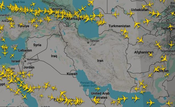
#GPS spoofing is scrambling #flights across the Middle #East, Turning the sky into a map of the war.

Ian at #Flightradar24 tells us how much we rely on GPS to keep the world moving.

https://www.iranwar.news/p/can-we-trust-gps-anymore

Can we trust GPS anymore?

GPS spoofing used to stop drones and missiles is also scrambling civilian flight data across the Middle East, making the war visible in the sky.

Iran War Dispatches with Tim Mak
Through #flight tracking, you can see a scar in the #sky – a zone where civilian aircraft dare not venture.
On tracking websites like #Flightradar24, the entire map of the second-largest country in the #Middle East is barren of the usual little yellow plane icons. Iraq is mostly blank too, as is #Syria, #Lebanon, #Israel, #Jordan, and #Kuwait. The #UAE depends on the day.
If you zoom in on an individual #flight, you might also see something stranger — jagged squiggly flight paths that look more like an EKG monitor than an airplane route. That’s #GPS spoofing, and it’s one massive part of this war that will affect all of us.

@timkmak that's kinda misleading

The jagged lines are usually the result of multilateration and not fake gps positions, you can dig in to specific examples to confirm

(source: me, a ground station receiver operator and data feeder to the tracking sites)

@timkmak the receivers fall back to multilateration when the aircraft's transponder GNSS has lost integrity

It's common in those areas for that to happen when GPS is jammed

But it's incredibly exceptionally super rare for that to be spoofing, I've only ever seen jamming and I've never seen spoofing in those data feeds