Could not sleep so spent time messing with the map.
Trying out lighter = lower elevation.
Added some mountain trails.
Added "Three Claw Valley" and "Riverford" labels thanks to @lkh suggestions.
All suggestions welcome.
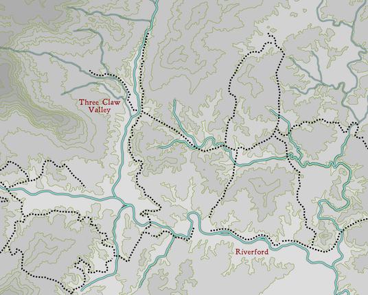
Could not sleep so spent time messing with the map.
Trying out lighter = lower elevation.
Added some mountain trails.
Added "Three Claw Valley" and "Riverford" labels thanks to @lkh suggestions.
All suggestions welcome.
@randomwizard @lkh So one line is a rather high but mostly gradual increase? Or is most of the maps rather low hills (or steep cliffs)?
Anyway, you could pick up a few "prime fortification spots", where you have both a source of water and some high defensive position nearby and place some settlements and/or fortifications.
@lkh @mhd @FrankBlack78 I copied the lines from topagraphic maps available at
https://ngmdb.usgs.gov/topoview/viewer/#4/39.98/-100.06
Although, I did not copy the all the lines, just the major ones. And I did not copy them exactly.
@kensanata @randomwizard @lkh @FrankBlack78 I'm not sure how much OSM etc. pre-render into their tiles and/or how easy it is to render your own without that.
I do know that some people are using the (quite complex, IMHO) GIS tools like QGIS for mapping, e.g. this one https://idraluna-archives.bearblog.dev/a-tutorial-for-making-hexcrawl-maps-in-qgis/
(They also made a few real-world maps including a high-res version of Antarctica: https://idraluna-archives.itch.io )