Here is the Venera 9 landing site on Venus. It's on the eastern edge of Beta Regio - remember that first radar map with a big rectangle called Beta? The image here is a combination of Magellan radar images and Magellan topography - not very successful really. If I had continued with this I would have re-done it just with radar images. Bright areas are rough in radar and there are lots of them. What will it look like on the ground? Let's go in closer.
#maps #venus

I missed a day so I will do two maps today. We are zooming in on the Venera 9 landing site. Yesterday it looked rough. This map shows a very fractured surface, cracks large and small all over the image. There were some gaps in radar coverage which I filled in with Earth-based radar, but it's not great. In the upper right is a lava channel (Omutnitsa Vallis). I think it flows towards the upper right where it is cut by several large fractures.
#maps #venus
#maps #venus

If fractures cut the lava channel they are younger than the channel. It's hard to tell where the lava came from, probably one of the set of north-south fractures west of the channel. The 'chasma' is a broad rift valley. The image in this post shows the site at high resolution, this time with the gaps in coverage not filled in. The gaps are caused by switching tracks on the tape recorder. See the little volcanic cone near the bottom right corner?
#maps #venus
#maps #venus

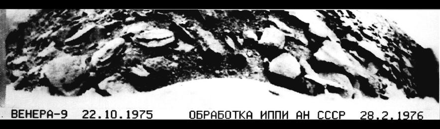
The link I posted earlier shows the Venera 9 panorama - here is the image in its raw form:
http://mentallandscape.com/C_Venera09.jpg
Don Mitchell explains how it was taken. A scanner runs from left to right across the scene, looking out at the horizon at left and right but down at the foreground in the middle (like the Luna 20 panorama we looked at a while ago). Then it ran back across the scene in the other direction for about 60% of a second panorama. It fills gaps in the first version.
#venus #venera9
This view on Don Mitchell's page shows how the original pan has many gaps (during which other telemetry was transmitted), how some of them can be patched from the second pan, and finally how the remaining gaps can be patched by interpolating. That's to make it look good, it doesn't add any new data. And that end of the pan was very broken up so you have to be careful about interpreting that part of the image.
First impressions: it's very rocky, a landscape of broken chunks of rock, some of them looking rounded (maybe by sandblasting as surface winds blow sediment around). Some look like they may be made of 2 or more layers. Between them is a gravelly surface. At right the horizon has rocks seen in silhouette against the sky - they can't be far away. At left a near horizon with rocks has a fainter landscape beyond it, faintly showing signs of more rocks.
#venus #venera9
#venus #venera9
We are probably looking across a valley at a slope on the other side, and right in the corner is a glimpse of a triangle of light. It's darker than the sky on the right - is it another hillside farther away? We see so little of it and the image is so damaged in that area that we don't really know what we are looking at. But a rough hilly landscape with lots of rocks is pretty much what the radar images from orbit suggest.
#venus #venera9
#venus #venera9
I want to make a map of this Venera 9 site. To start, here is a Soviet-era version of the panorama. I do want to emphasize what an incredible advance this was - the first image of the landscape of another planet, taken in October 1975, before the Viking landings on Mars. Nobody else has done this, and the Russians took 6 panoramas at 4 sites. Venus exploration was the greatest achievement of the Soviet planetary program.
#venus #venera9
#venus #venera9
I wanted to be able to map the Venera landing sites. We should be able to project the panoramas to a map geometry. I'm not clever enough to figure it out, but veteran space artist Don Davis published drawn maps for Veneras 9 and 10, so I had a start. He didn't map the outer ends of the images so I had to improvise that bit. This image is a first attempt at projecting the Venera 9 pan to a map. It could be improved considerably.
#venus #venera9
#venus #venera9
A small point and a big one about yesterday's map made from the Venera 9 panorama. First, at the left end we see a more distant hillside (or possibly two) beyond a near horizon (or perhaps two). I should have separated the bit beyond the closest horizon to suggest an intervening valley - I'll show it in the next post so you can see what I mean. The bright spot at far left might be a third hillside beyond another valley. It's darker than the sky at the right. Second...
#venus #venera9
#venus #venera9
Here's that map with its crudely separated section. But what's this? Why have I rotated it? As far as I can tell there is absolutely no information about the orientation of the map, so here it is in an arbitrary orientation. I suppose a whole-sky image might have revealed the direction of the sun (30 degrees above the horizon), but we don't have one. Shadows don't tell us anything, they are all just under rocks, not to one side. There's a lot we don't know.
#venus #venera9
#venus #venera9
When we looked at Soviet lunar missions I showed the Luna 22 bistatic radar image of part of the Moon. It didn't tell us much we didn't know about the Moon (rocky surfaces and slopes facing the radar will reflect it on to the detector). But a year later Venera 9 used bistatic radar to study Venus, an utterly unknown surface, so in a sense the Luna 22 lunar data are like 'ground truth' for Venus. The results were published at the time in a Russian journal...
#venus #venera9
#venus #venera9
... but when Magellan images became available they attracted more attention:
https://www.hou.usra.edu/meetings/lpsc2016/pdf/2094.pdf
(similar content, slightly more condensed URL)
If I continued with my Venus atlas project I would certainly have been mapping this stuff, but it's not going to happen.
Tomorrow it's time to move on the Venera 10.
#venus #venera9
Venera 10 launched 6 days after V9 (14 June '75) and landed 3 days after its sibling (25 October). This map shows the area. Like Venera 9 it was east of Beta Regio, but 1500 km further south. As with all landers so far the target was essentially unknown, only seen in very low resolution radar reflectivity images from Earth. Here we see a landscape of bright (rough) and dark (smoother) features, which we will see closer tomorrow.
#venus #venera10
#venus #venera10

Venera 10 landed in the area shown here at two scales - at left a map spanning 500 km shows major landforms, at right, full Magellan resolution gives us details of part of the landing ellipse. We see mixed geology - the dark areas are smooth (ish) plains, probably sediments blown around by the wind. What makes sediment on Venus? Impacts, chemical weathering and maybe volcanic ash. A big bright area (Hyndla Regio) is an upland cut by many faults.
#venus #venera10
#venus #venera10

The south part of the map contains a large volcanic shield (Samodiva Mons) which has released lava flows showing up as brighter lobate markings extending north and east from the shield. The 300 km circle is the landing location - it could be anywhere in there. The closeup, 100 km wide, shows the plains cut by ridges (east-west) and fractures (north-south). The bright hills are cut by many fractures. Little domes at the left edge are small volcanoes. What did Venera 10 land on?
#venus #venera10
#venus #venera10
OK, what did Venera 10 see? This is the link I gave earlier to Don Mitchell's page about Venus images:
http://mentallandscape.com/C_CatalogVenus.htm
and here is the raw Venera 10 image:
http://mentallandscape.com/C_Venera10.jpg
His expert processing gives us this:
http://mentallandscape.com/C_Venera10_Processed.jpg
(raw, gaps filled from second image, remaining gaps filled by interpolation)
Both of these Venera landers carried a second camera on the opposite side of the lander, but in each case it failed to operate.
#venus #venera10
Here is an old Soviet version of the Venera 10 image, a bit too contrasty so details get lost especially at the horizon. But what we see is different from Venera 9's boulders. This is a nearly flat area with platy slabs of rock interspersed with darker gravelly soil. One of the rocky slabs is cracked. The two objects are a densitometer to measure surface hardness and a lens cover ejected from the camera after landing.
#venus #venera10
#venus #venera10

We have seen the Venera 9 and 10 panoramas, but take a look at this from the Planetary Society:
https://www.planetary.org/space-images/rectified-vs-original-venera-9-and-10-panoramas
(presented without any explanation on that page). This version has more detail:
https://www.planetary.org/space-images/standing-on-venus-with-venera-10
These are artistic re-workings of the panoramas, rearranging bits of the images to create a more understandable view. I show them because they pop up in image searches and are often misrepresented as original images.
#venus #venera10

My pal and occasional co-author Ted Stryk made them - with good intentions, to help people get some idea of what Venus looks like on the surface, because the Russian panorama format is harder to understand. I'm not sure it is really a good idea to do this just because people can get the wrong idea. You do have to be careful taking anything at face value on the internet. Look at me for instance. I could be a total charlatan. (buy my books!!!)
#venus
#venus
Here is a rather crudely reprojected version of the Venera 10 panorama. Once again we don't know the orientation of this map. The lander ended up on a patch of flat rocky slabs, and there seem to be similar rocky areas on each horizon, left and right. Between them are darker gravelly surfaces. The big remaining question would be - where is this in the Magellan radar image we saw earlier? I think this is in the plains, but we can't say exactly where.
#venus #venera10
#venus #venera10

Around the time of Veneras 9 and 10, Earth-based radar mapping was improving. This map is a composite of two radar datasets from this period, reprojected to the azimuthal projection I always use for global maps.
One paper was this:
Campbell, D.B. and Burns, B.A., 1980. Earth‐based radar imagery of Venus. Journal of Geophysical Research: Space Physics, 85(A13), pp.8271-8281.
The other... I think it was in Geophys. Res. Lett. but I haven't tracked it down yet.
#venus #radar

This all looks very nice, but we still don't know much about what is being seen. Take the very bright area Maxwell at the top - is it a mountain range or a canyon like Juventae Chasma on Mars? We only know it's rough. (Now we know it's a mountain) What about the dark smooth area with a bright rim west of Maxwell? Is it a plateau or a depression?. These images suggest lots of tectonic activity but interpretations are very uncertain.
#venus
#venus
The next mission to launch to Venus was NASA's Pioneer Venus mission, with two components. Here is a NASA look back on its 40th anniversary:
https://www.nasa.gov/centers-and-facilities/ames/40-years-ago-pioneers-encounter-venus/
The mission consisted of an orbiter and a multiprobe carrier, launched separately. We will deal with the orbiter first, then look at the probe mission. The image is one of many taken by the orbiter, and here are several more:
https://commons.wikimedia.org/wiki/Category:Photos_by_Pioneer_Venus_1

At first we knew absolutely nothing about the surface of Venus. Then we saw bright radar-reflective spots, but we didn't know if they were high or low or had any relief at all. It took Pioneer Venus to give us our first topographic dataset using a radar altimeter (far less precise than a laser altimeter, but lasers won't work at Venus). Here is an early map, and it comes with the first feature names. Now we can see Maxwell is a high mountain.
#venus #pioneervenus
#venus #pioneervenus

This link:
https://www.lpi.usra.edu/resources/venus_maps/
gives you lots of Venus maps by USGS, but for today we want the top one:
https://www.lpi.usra.edu/resources/venus_maps/1324/I-1324_150.jpg
The map in the previous post was hard to read but this is much clearer. There are 2 obvious continent-scale highland areas (remember Venus is about as big as Earth) Earth. 10 degrees of latitude or along the equator is approx. 1000 km for scale. The poles were not mapped, but our modern view of the planet is becoming clear.
#venus #pioneervenus

Pioneer Venus also made a very low resolution radar image of the equatorial region of Venus. If I can find it I will post it tomorrow. But let's look now at the probes it dropped into the atmosphere. There were 3 small probes, one on the day side of the terminator, one on the night side, one in the north near the Maxwell radar feature (not known during mission design). A large probe and the carrier spacecraft ('bus') also entered the atmosphere.
#venus #pioneervenus
#venus #pioneervenus
Here is a map showing their target points and actual sites. They were pretty close to the targets. These were studying the atmosphere, not the surface, and were not expected to survive landing (they just fell, no parachutes except for the large probe). However, the Day probe transmitted from the surface for over an hour and the night probe for 2 seconds (it probably fell over). The bus had instruments too and gave data until it burned up.
#venus #pioneervenus
#venus #pioneervenus

Here are a set of close-up views of the Pioneer Venus sites. First the large probe (which operated down to the surface) and the bus or carrier spacecraft which burned up in the atmosphere (having no heatshield). And surviving fragments of the bus fell in the area indicated. The close views at right (100 km across) show the large probe fell in a region of extensive lava flows and the bus broke up over over a heavily faulted region.
#venus #pioneervenus
#venus #pioneervenus

Here are the remaining 3 Pioneer Venus probe sites. Remember that these were targeted for atmospheric, not geological observations and the geology was unknown. Only the Day probe survived on the surface for any significant time. All 3 sites are lava plains crossed by ridges and fractures, a very common landform on Venus. The night probe is close to Maxwell Montes - how interesting it would be to land on top of it...
#venus #pioneervenus
#venus #pioneervenus

The temperature and pressure would be significantly lower on top of Maxwell - still hellish for us but a little bit less hellish than elsewhere, maybe allowing a longer survival time on the surface. The composition of these bright mountain tops seems to be different as well, so it would be interesting to probe it. But there are more exciting targets - the favourite goal for future landers is the tesserae (fractured uplands) which may be bits of older crust.
#venus #pioneervenus
#venus #pioneervenus
I am a cartographer, so all I want to do all day and half the night is mark things on maps. Pioneer Venus orbited Venus and eventually entered the atmosphere and burned up. The chances of anything reaching the surface are slim, but that's not the point - I would like to be able to say 'Pioneer Venus burned up over ----- Planitia, Magellan burned up over ---- Terra, Venus Express burned over --- Tessera. It should be simple, but it's not. Let's look at the problem.
#venus
#venus
These orbiters were all in quite elongated high inclination orbits, so they can only enter the atmosphere at (or near) their periapsis latitude, and we know what that is for the final phase of each mission, so the latitude is fixed quite easily. The longitude is much more complicated. The orientation of the orbit plane in space would be known. The question is, which bit of the planet was under the periapsis at the time of atmospheric entry on the last orbit?
#venus
#venus
I'm not clever enough to put all this together and answer my own question, and I have asked the internet at least once (on unmannedspaceflight.com) but to no avail. I might have an answer for Pioneer Venus so let's look at it. I jotted these notes down years ago and don't recall where my information was from. But this is what I have:
Last contact was on 8 October 1992. The last orbit was on 22 October...
#venus
Last contact was on 8 October 1992. The last orbit was on 22 October...
#venus
The periapsis was near midnight on Aug. 28, when the subsolar longitude was about 208 degrees east, so periapsis longitude was about 28 east. On the last orbit, 40 days later, the periapsis long. should be about 86 east. Therefore the place where Pioneer Venus burned up should be about 11 south (periapsis latitude) and 86 east, on the south edge of Ovda Regio (you can find it on my probe location map). I don't have similar data for other orbiters and am not confident about this one.
#venus
#venus
The next events in our Venus story were the Venera 11 and 12 missions. These were upgraded landers with colour cameras and better analytical instruments for the atmosphere and surface. They were not accompanied by orbiters this time, but their carrier spacecraft flew past Venus, and relayed data from the landers. Two landers, two cameras each... but not one of the 4 cameras worked. We don't have pictures, but let's see where they went - tomorrow!
#venus
#venus
When we have seen the most recent Venus lander (it wasn't very recent) I will post a map showing all lander locations on the planet. Meanwhile, here is the region where Veneras 11 and 12 landed in December 1978. When I was making these illustrations I did not know the figure numbers so they are omitted here. I can reveal that Venera 11 was --B and Venera 12 was --C. This is a complex region of rough uplands and smooth plains south of Beta Regio.
#venus #venera11 #venera12
#venus #venera11 #venera12

Here is the Venera 11 landing site in a context map and a closeup at full Magellan resolution. The 2nd map spans about 100 km side to side and is roughly centred in the 300 km circle in the context map. This is a very smooth plains site: lava flows with a veneer of sediment, most likely. White lines are rough-faced fractures (faults), and there are also some fine dark lines, maybe older fractures (or facing away from the radar). The darker area is smoother, maybe fine dust.
#venus #venera11
#venus #venera11

These maps show the same thing for Venera 12, but this is a very different site. Most of the context map consists of Tessera terrain - rough uplands cut by dense sets of fractures running in different directions. The closeup view at right shows at least 3 sets of fractures with different azimuths. Tesserae are thought to be areas of older crust which have been around long enough to be disrupted by multiple episodes of faulting. A dangerous place to land!
#venus #venera12
#venus #venera12

Despite the danger of trying to land in a very rugged area like Venera 12's site, the apparent age of tessera areas makes them the most favoured sites for new landing missions. How can you make the landing less dangerous? The best plan seems to be: aim for the ejecta of an impact crater in the tessera. The ejecta is made of the stuff you are interested in, but the ejecta deposit covers over the rough terrain, smoothing the surface.
#venus
#venus
While the Veneras were flying, Earth-based radar continued to probe Venus. Here are some radar results from the 1980s. The top image is radar reflectivity - bright is reflective, and it is rough terrain. The resolution is improving. Look at Myletta Fluctus (fluctus = flow), a vast lava flow, about 750 km end to end. The other bright features are tectonic ridges and fractures. Venus has been a geologically active world, most likely it still is.
The other images? That's a new story.
#venus

A JPL team led by Richard Goldstein made these circular images at Goldstone over 2 decades. The black band masks unresolved north-south ambiguity at the radar equator. These are at the middle of the planet's disk on that date where a very bright specular reflection occurs, and radar behaves differently in it than elsewhere. Slopes facing the radar are bright. Rough areas scatter radar away and are dark in his area. Look at the VERY fine ridges at the top of 'C', never seen before.
#venus #radar
#venus #radar
Goldstein started this in the early 1970s and got a few images at each close approach of Venus. The method also gave rough topography of the area. I was fascinated by the slow unveiling of Venus's surface over this period and attempted some geological analysis, which we will look at tomorrow. Goldstein was very generous with me and sent photo prints of all his images over the years.
#venus #radar
#venus #radar
This link goes to my first Venus mapping abstract at LPSC:
I was still a near-beginner at geological mapping and at interpreting radar images, but I think it still looks reasonable now. The map covers all the Goldstone images available at the time (1988, I was still a grad student). I mis-spelled Eistla in 2 different ways! Oh well...
Here is another abstract from 1991 with a version of the map extended by using other radar images:
This is a more complex argument and I'm going to look at it more closely later. Basically, before this two authors had published a hypothesis about Aphrodite being a spreading ridge like those we see on Earth's ocean floors. It had an axis of symmetry which was offset by faults at right angles to the axis. It looked like a reasonable idea... but...
#venus #radar
The previous hypothesis was that Aphrodite was a spreading ridge like the Mid-Atlantic Ridge, its axis offset by 'cross-strike discontinuities' (CSDs - we used to call them transform faults), but these were all in the hemisphere not seen in Earth-based radar. My idea was that the basic pattern of an axis of symmetry offset by parallel CSDs could be extended from Aphrodite into Eistla Regio where we did have radar images. The images might let us test the hypothesis.
#venus #radar #maps
#venus #radar #maps
After analysis my conclusion in that abstract was that there was no evidence in Earth-based radar images for the spreading hypothesis. I went on to write this up in more detail and submitted it to a journal. The referees rejected it on spurious grounds - I think the people I was saying were wrong were doing the refereeing. I didn't pursue the point, but this plus one other case later - a totally different topic - made me give up on the journal treadmill and start compiling atlases.
#venus
#venus
We now pass to Veneras 13 and 14, which gave us the best images we have of the surface of Venus. Where did they land? This map shows the previous 2 sites (Veneras 11 and 12) and two cryptically labelled boxes - I did not know the final figure numbers when I made this. B is Venera 13, C is Venera 14. The area is a mixture of rough uplands (e.g. Dolya Tessera), smooth plains (e.g. Navka Planitia), volcanic features and associated lava flows. What will this look like on the ground?
#venus
#venus

Here is the Venera 13 landing site in a context map (left) and a closeup (right), using Magellan images. Wen Shu is an impact crater. Muru Tholus is a volcano, and the Fossae are troughs or linear valleys. The closeup (100 km across) is a mixed bag of geology. Bright (rougher) hilly areas and smooth (darker) plains. Smaller dark spots are smoother surfaces, maybe sediment blown into depressions by the wind. Venera 13 can be anywhere in the big circle. What did it see?
#venus #maps
#venus #maps

Venera 13 had 2 cameras and both worked this time, giving 2 panoramas facing in opposite directions. As usual Don Mitchell gives us an excellent treatment of these panoramas:
http://mentallandscape.com/C_CatalogVenus.htm
(about 40% of the way down the page). The scene was scanned through 3 filters plus a clear filter so we have RGB images, nearly complete for one camera, only partial for the other. Here's one of them from that site:
What do these images tell us? The landscape is superficially similar to that of Venera 10, with eroded and broken rock slabs separated by areas of darker gravelly debris. These Soviet versions of the images (from the NSSDCA) show the colour scale on the right side of the images and 2 camera covers which were ejected after landing, plus an arm which gave a reading of the hardness of the surface. This is probably in the dark plains area of the Magellan image.
#venus #venera13
#venus #venera13

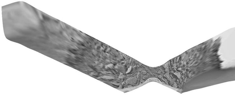
Once you have those panoramas you can do some other things with them. Each one sees the horizon at each end and the foreground in the middle, so they can be projected into a sort of cylindrical projection which straightens the horizon. Here are the two Venera 13 panoramas.

Since I didn't do this with Veneras 9 and 10, I will add them here. The processing here shows the distant blocky ridge at the Venera 9 site better than we saw it before.
#venus
#venus

The two Venera 13 panoramas should overlap slightly at their ends so they can be joined as shown here. This shows the actual extent of horizon imaging which is very limited. The overlap is visible at one end but largely obscured by part of the lander at the other end. The bit we see overlapping doesn't match exactly because the view angle is different (it would make a mini-stereo pair). It's too bad the Soviet camera system gave such a limited view, but it's amazing we got anything.
#venus
#venus

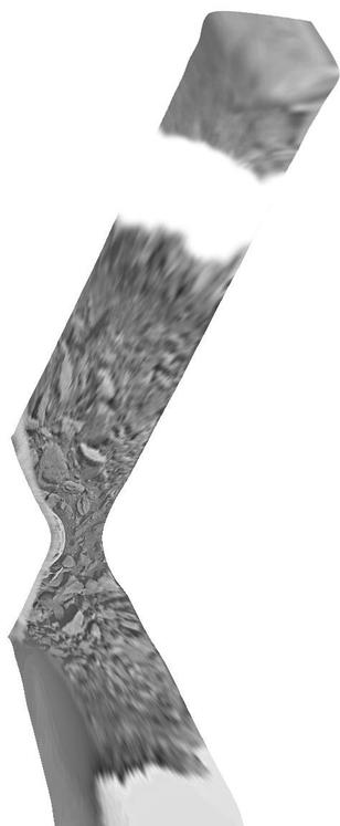
Once we have that panorama we can try to project it into a map geometry like this. I know this is not very good geometry, I just did it quickly yesterday. But it gives an idea of what the 'map' coverage is like - not very complete! The odd orientation reinforces the fact that (as I believe) we don't really know the orientation of the scene. Someone with a better grasp of the geometry could make a better version of this.
#venus #venera13
#venus #venera13

Here is a quick closeup of the middle of the previous post at the original scale I worked at.
#venus #venera13
#venus #venera13

Venera 13 didn't just image its surroundings. It analyzed surface composition, recorded sounds including various spacecraft activities, and recorded electrical discharges in the atmosphere. It survived for 127 minutes on the surface - quite remarkable considering the conditions on Venus. A parachute slowed it down but the lander was released from the parachute at 50 km altitude and it just fell to the surface.
#venus #venera13
#venus #venera13
Now we move on to Venera 14, which landed only a few days after Venera 13. I showed a context map of its site and V13's earlier. Here are two closer views. This is a volcanic terrain. Panina Patera is a volcanic eruption site surrounded by vast lava flows (Darago Fluctus). Ingrid is an impact crater. There are many faults and ridges west of the Patera and lava flows mainly to its east, extending at least 300 km.
#venus #maps #venera14
#venus #maps #venera14

What did Venera 14 see in this volcanic landscape? Again we will check in with Don Mitchell:
http://mentallandscape.com/C_CatalogVenus.htm
- look half way down the page. Both cameras worked again, both provided some colour data (most of one pan, a bit of the other). My image is something I scanned in Moscow, showing map-projected versions of the central parts of the two panoramas, on opposite sides of the lander. These are presumably thin lava flows or cemented ash layers.
#venus #venera14

@PhilStooke
Is there a good source of the sound recordings?
Also the 50km fall is impressive.
@PhilStooke A few years ago, someone took similarly reprocessed images and a 3D reconstruction of one of the Veneta landers and assembled an interactive 3D projection that was truly stunning. It made me feel like I was actually looking at the surface in person. So real. I haven't been able to find it since...