Perhaps the most unusual feature in this map is Adivar, a small impact crater at top right, Adivar is the bight spot, and around it we see a less bright patch and then a dark horseshoe or inverted 'C' shape opening to the west. This is ejecta thrown out of the crater but blown westward by the prevailing wind. There are quite a few of these on Venus, just around younger craters. All these features are named after women.
#maps #venus
There were two other attempts at Venus in 1965 which did not leave Earth. The next opportunity was 1967. Venera 4 was launched on 12 June 1967 and entered the planet's atmosphere on 18 October, still functioning. It would float if it landed in water, which was still thought a possibility because Soviet scientists thought the very high temperatures reported by Mariner 2 were in the ionosphere, not the surface. It failed at an altitude of 25 km. A map follows...
#venus
#venus
This map shows the Venera 4 location, the nature of which was still unknown. Now we see it as a volcanic upland with a high mountain (Tepev Mons) and several coronae or roughly circular volcanic complexes. The day after this, Mariner 5 flew past Mars and detected high temperatures again. The Soviets suggested they landed on a high peak giving lower temperatures and pressures, but eventually agreed Venera 4 failed during the descent.
#maps #venus
#maps #venus

I still had not settled on figure numbers when I did this, hence the 'Fig. --B' label.
I should have added that Venera 3 and 4 were delivered by carrier spacecraft which also entered the atmosphere, ejecting the lander just before arrival. Any remaining fragments of them would lie near the landers themselves.
We will take a closer look at the centre of the landing ellipse tomorrow.
#venus
Here is the central part of the Venera 4 landing area seen at full Magellan resolution, about 100 m/pixel. The image spans 200 km left to right. White lines are fractures, hundreds of hem - a tectonically disrupted landscape. At right is a band of fractured terrain forming the outer rim of Didilia Corona, a volcanic complex. At left is a rougher area with even bigger fractures, a central uplift. The bland, darker areas are covered with wind-blown sediment.
#maps #venus
#maps #venus

The radar image in the last post shows a small bright volcanic cone with a summit pit, and maybe another one not far from it. Lots of small pits, probably volcanic, but no obvious impact craters. Later I will add a map showing where these sites are on the planet.
The atmosphere is so thick that a falling object hits the surface relatively slowly. These landers could be nearly intact, maybe badly dented - but probably not the strewn field of fragments we would expect on the Moon.
#venus
There was another failed launch after Venera 4 in 1967, so the next opportunity was in 1969. Veneras 5 and 6 were improved... two problems with landing on Venus are high temperatures and high pressures. The new landers were strengthened to survive higher pressure, and allowed to descend faster on a smaller parachute to get down before overheating. Nevertheless Venera 5 failed at 25 km and Venera 6 failed at 11 km altitude. Venus is tough.
#venus
#venus
These maps show the Venera 5 and 6 landing areas, close together. They were still essentially unknown landscapes. The second of two radar maps I showed earlier was the state of the art about this time and all it gives is a vague idea of radar reflectivity at low resolution. Even with Magellan data we see rather nondescript plains cut by ridges and fractures. Now we would have better ideas about where to land - we'll see some of that later.
#maps #venus
#maps #venus

These are closeups, full Magellan resolution, of the Venera 5 and 6 sites: squares 100 km across inside each circle in yesterday's post. The surfaces are all lava flows and lighter patches are rougher surfaces. The thicker, wavy, east-west trending white lines are ridges produced by compression acting north-south. The thinner lines crossing the ridges are fractures produced by tension perpendicular to the fractures. There are no craters. Let's consider Venera 5 first.
#maps #venus
#maps #venus

The Venera 5 image has two brighter (rougher) patches. They could be older surfaces sticking up through the lava or younger flows not yet partly mantled by wind-blown sediment. To tell the difference I would look for fractures truncated by the boundary of the patch. A fracture on a bright patch but not seen on the plains suggests the patch is older than the surroundings and vice versa. But I can't see any such features, so not much help. There's a hint of a sinuous channel at the right.
#venus
#venus
The Venera 6 site is superficially similar but has no obvious brighter patches. One very prominent linear fracture (with a faint shadowed wall on the left in this right-looking radar image) has a sinuous channel extending from its southern end and out to the lower right corner of the image. It's a lava channel, and the big fracture has acted as a vent. Venus channels can be thousands of km long, cut by very fluid lavas.
#venus
#venus
But remember, at the time of these missions, none of this was known. We were utterly ignorant of the geology of Venus.
Tomorrow... the first successful landing on the surface of Venus. In fact it was the first successful landing on any planet.
Venera 7 launched on 17 August 1970 and reached Venus on 15 December. A twin spacecraft launched 5 days later and never left Earth orbit. Venera 7 was refrigerated to help it last longer in the hellish atmosphere and survived the 35 minute descent. It continued transmitting for 23 more minutes, but very weakly, perhaps because it fell over after landing on a steep slope or very rough ground. A pressure of 90x our sea level atmosphere was measured. Where did it go?
#venus
#venus
Here is the Venera 7 landing region. It landed at night and did not take images. The site is close to a large circular corona - a volcanic and tectonic structure 1000 km across called Heng-o Corona. We see several 'dorsa' (ridge) structures and a 'chasma' (a big rift valley). The 'planitia' is a low altitude fairly smooth plain. We will see more detail tomorrow. This was the first landing on another planet. The whole Venus program was the highlight of Soviet planetary exploration.
#maps #venus
#maps #venus

These images give more detail of the Venera 7 site on Venus. In the context map (left) we see an impact crater (Buck), a set of ridges collectively called Unuk Dorsa and a feature described as a 'fluctus' (flow) - in this case a lava flow. The darker plains are lava flows too but partly covered with wind-blown sediment, making them smoother. The closer view, 100 km across at full Magellan resolution, shows wiggly lines which are the ridges and a few straight fractures.
#maps #venus
#maps #venus

If Venera 7 did, as suspected, land but fall over because it landed on a steep local slope, it was unlucky. This is mostly a nice smooth level landing site.
Another day, another lander... tomorrow.
#venus
Venera 8 launched on 27 March 1972 and landed on Venus on 22 July. A companion spacecraft launched 4 days later but never left Earth orbit. Venera 8 landed just after dawn at its site and measured light levels but had no camera. It ejected a radio transmitter as it landed in case it fell over like Venera 7 (but it didn't need it). This map shows the location, not too far from Venera 7. We'll see all these sites in context later. The surface here is more complex than earlier sites.
#maps #venus
#maps #venus

Let's look closer at the Venera 8 landing site. Now the mission team knew they could reach the surface it made sense to measure composition with a gamma ray instrument. Earlier probes had mostly studied the atmosphere during descent. The composition was expected to be basaltic but more potassium was found than expected. Does the site tell us anything about this? Not with any certainty. These maps show the surface, with a close-up of an interesting little volcanic dome.
#maps #venus
#maps #venus

The Magellan radar mosaic has a few missing areas - Magellan did not provide 100% surface coverage. There are a few larger gaps and lots of little ones like these. Magellan data came in as strips covering an area about 20,000 km long (almost pole to pole) but only a few tens of km wide (I forgot to look up the width). When you fit them together you get occasional missing gores and some gaps where the tape recorder switched tracks - yes, all this was done with a tape recorder.
#maps #venus
#maps #venus
Irregular dark patches seem to be smooth lava flows filling depressions in a rougher surface. The 'colles' features are hills. A round dome (Zorya Tholus), 20 km across to give scale, is presumably volcanic. Is the dome the potassium-rich feature? Or the lava flows? Or the hills? We don't know because we don't know exactly where the lander reached the surface.
Venera 3... 4... 5... 6... 7... 8... can 9 be next? Well, no, because the next Venus mission was from NASA. Tomorrow!
#venus
Our next Venus mission was a Mercury mission - Mariner 10 - but it flew past Venus to get a gravity assist. This was the first ever gravity assist, something we now take for granted. During the flyby images of the cloud tops were taken, revealing far more detail than Earth-based telescopes, especially in ultraviolet. The magnetometer showed the lack of a magnetic field. Mariners 2 and 5 and Venera 4 had also given some data on this. What did the pictures look like?
#venus
#venus
At the time images like this from Mariner 10 were released:
https://www.nasa.gov/image-article/mariner-10s-first-close-up-photo-of-venus/
This is ultraviolet. The clouds would be almost featureless to our eyes. But Mariner 10 also took pictures in orange light. Modern image processing software can use the two sets of images to show something much prettier:
https://www.jpl.nasa.gov/images/pia23791-venus-from-mariner-10/
When I google for these images I am seeing a lot of Pioneer Venus images misrepresented as Mariner 10 images. #venus

Now things are going to get more exciting. Venera 9 was the first mission to land on Venus with a camera and return images of the surface. Not so well known is that it was accompanied by an orbiter which imaged the clouds with a scanning camera (related to those tested on Lunas 19 and 22). If you want to understand Soviet planetary images you have to see Don Mitchell's site:
http://mentallandscape.com/C_CatalogVenus.htm
But no peeking ahead to other missions...
#venus
I'll let you digest what Mitchell gives us for Venera 9, and tomorrow we will look at the landing site.
I had big plans to map the Venera landing sites but I didn't get very far with it before Mars took over my life. But I will post whatever I can find in my old files.
#venus
Here is the Venera 9 landing site on Venus. It's on the eastern edge of Beta Regio - remember that first radar map with a big rectangle called Beta? The image here is a combination of Magellan radar images and Magellan topography - not very successful really. If I had continued with this I would have re-done it just with radar images. Bright areas are rough in radar and there are lots of them. What will it look like on the ground? Let's go in closer.
#maps #venus
#maps #venus

I missed a day so I will do two maps today. We are zooming in on the Venera 9 landing site. Yesterday it looked rough. This map shows a very fractured surface, cracks large and small all over the image. There were some gaps in radar coverage which I filled in with Earth-based radar, but it's not great. In the upper right is a lava channel (Omutnitsa Vallis). I think it flows towards the upper right where it is cut by several large fractures.
#maps #venus
#maps #venus

If fractures cut the lava channel they are younger than the channel. It's hard to tell where the lava came from, probably one of the set of north-south fractures west of the channel. The 'chasma' is a broad rift valley. The image in this post shows the site at high resolution, this time with the gaps in coverage not filled in. The gaps are caused by switching tracks on the tape recorder. See the little volcanic cone near the bottom right corner?
#maps #venus
#maps #venus

The link I posted earlier shows the Venera 9 panorama - here is the image in its raw form:
http://mentallandscape.com/C_Venera09.jpg
Don Mitchell explains how it was taken. A scanner runs from left to right across the scene, looking out at the horizon at left and right but down at the foreground in the middle (like the Luna 20 panorama we looked at a while ago). Then it ran back across the scene in the other direction for about 60% of a second panorama. It fills gaps in the first version.
#venus #venera9
This view on Don Mitchell's page shows how the original pan has many gaps (during which other telemetry was transmitted), how some of them can be patched from the second pan, and finally how the remaining gaps can be patched by interpolating. That's to make it look good, it doesn't add any new data. And that end of the pan was very broken up so you have to be careful about interpreting that part of the image.
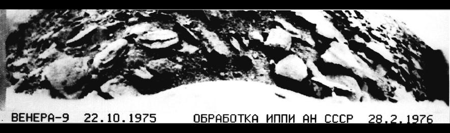
First impressions: it's very rocky, a landscape of broken chunks of rock, some of them looking rounded (maybe by sandblasting as surface winds blow sediment around). Some look like they may be made of 2 or more layers. Between them is a gravelly surface. At right the horizon has rocks seen in silhouette against the sky - they can't be far away. At left a near horizon with rocks has a fainter landscape beyond it, faintly showing signs of more rocks.
#venus #venera9
#venus #venera9
We are probably looking across a valley at a slope on the other side, and right in the corner is a glimpse of a triangle of light. It's darker than the sky on the right - is it another hillside farther away? We see so little of it and the image is so damaged in that area that we don't really know what we are looking at. But a rough hilly landscape with lots of rocks is pretty much what the radar images from orbit suggest.
#venus #venera9
#venus #venera9
I want to make a map of this Venera 9 site. To start, here is a Soviet-era version of the panorama. I do want to emphasize what an incredible advance this was - the first image of the landscape of another planet, taken in October 1975, before the Viking landings on Mars. Nobody else has done this, and the Russians took 6 panoramas at 4 sites. Venus exploration was the greatest achievement of the Soviet planetary program.
#venus #venera9
#venus #venera9
I wanted to be able to map the Venera landing sites. We should be able to project the panoramas to a map geometry. I'm not clever enough to figure it out, but veteran space artist Don Davis published drawn maps for Veneras 9 and 10, so I had a start. He didn't map the outer ends of the images so I had to improvise that bit. This image is a first attempt at projecting the Venera 9 pan to a map. It could be improved considerably.
#venus #venera9
#venus #venera9
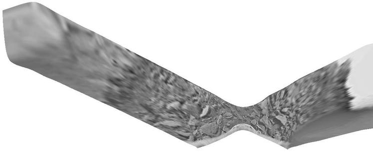
A small point and a big one about yesterday's map made from the Venera 9 panorama. First, at the left end we see a more distant hillside (or possibly two) beyond a near horizon (or perhaps two). I should have separated the bit beyond the closest horizon to suggest an intervening valley - I'll show it in the next post so you can see what I mean. The bright spot at far left might be a third hillside beyond another valley. It's darker than the sky at the right. Second...
#venus #venera9
#venus #venera9
Here's that map with its crudely separated section. But what's this? Why have I rotated it? As far as I can tell there is absolutely no information about the orientation of the map, so here it is in an arbitrary orientation. I suppose a whole-sky image might have revealed the direction of the sun (30 degrees above the horizon), but we don't have one. Shadows don't tell us anything, they are all just under rocks, not to one side. There's a lot we don't know.
#venus #venera9
#venus #venera9
When we looked at Soviet lunar missions I showed the Luna 22 bistatic radar image of part of the Moon. It didn't tell us much we didn't know about the Moon (rocky surfaces and slopes facing the radar will reflect it on to the detector). But a year later Venera 9 used bistatic radar to study Venus, an utterly unknown surface, so in a sense the Luna 22 lunar data are like 'ground truth' for Venus. The results were published at the time in a Russian journal...
#venus #venera9
#venus #venera9
... but when Magellan images became available they attracted more attention:
https://www.hou.usra.edu/meetings/lpsc2016/pdf/2094.pdf
(similar content, slightly more condensed URL)
If I continued with my Venus atlas project I would certainly have been mapping this stuff, but it's not going to happen.
Tomorrow it's time to move on the Venera 10.
#venus #venera9
Venera 10 launched 6 days after V9 (14 June '75) and landed 3 days after its sibling (25 October). This map shows the area. Like Venera 9 it was east of Beta Regio, but 1500 km further south. As with all landers so far the target was essentially unknown, only seen in very low resolution radar reflectivity images from Earth. Here we see a landscape of bright (rough) and dark (smoother) features, which we will see closer tomorrow.
#venus #venera10
#venus #venera10

Venera 10 landed in the area shown here at two scales - at left a map spanning 500 km shows major landforms, at right, full Magellan resolution gives us details of part of the landing ellipse. We see mixed geology - the dark areas are smooth (ish) plains, probably sediments blown around by the wind. What makes sediment on Venus? Impacts, chemical weathering and maybe volcanic ash. A big bright area (Hyndla Regio) is an upland cut by many faults.
#venus #venera10
#venus #venera10

The south part of the map contains a large volcanic shield (Samodiva Mons) which has released lava flows showing up as brighter lobate markings extending north and east from the shield. The 300 km circle is the landing location - it could be anywhere in there. The closeup, 100 km wide, shows the plains cut by ridges (east-west) and fractures (north-south). The bright hills are cut by many fractures. Little domes at the left edge are small volcanoes. What did Venera 10 land on?
#venus #venera10
#venus #venera10
OK, what did Venera 10 see? This is the link I gave earlier to Don Mitchell's page about Venus images:
http://mentallandscape.com/C_CatalogVenus.htm
and here is the raw Venera 10 image:
http://mentallandscape.com/C_Venera10.jpg
His expert processing gives us this:
http://mentallandscape.com/C_Venera10_Processed.jpg
(raw, gaps filled from second image, remaining gaps filled by interpolation)
Both of these Venera landers carried a second camera on the opposite side of the lander, but in each case it failed to operate.
#venus #venera10
Here is an old Soviet version of the Venera 10 image, a bit too contrasty so details get lost especially at the horizon. But what we see is different from Venera 9's boulders. This is a nearly flat area with platy slabs of rock interspersed with darker gravelly soil. One of the rocky slabs is cracked. The two objects are a densitometer to measure surface hardness and a lens cover ejected from the camera after landing.
#venus #venera10
#venus #venera10

We have seen the Venera 9 and 10 panoramas, but take a look at this from the Planetary Society:
https://www.planetary.org/space-images/rectified-vs-original-venera-9-and-10-panoramas
(presented without any explanation on that page). This version has more detail:
https://www.planetary.org/space-images/standing-on-venus-with-venera-10
These are artistic re-workings of the panoramas, rearranging bits of the images to create a more understandable view. I show them because they pop up in image searches and are often misrepresented as original images.
#venus #venera10

My pal and occasional co-author Ted Stryk made them - with good intentions, to help people get some idea of what Venus looks like on the surface, because the Russian panorama format is harder to understand. I'm not sure it is really a good idea to do this just because people can get the wrong idea. You do have to be careful taking anything at face value on the internet. Look at me for instance. I could be a total charlatan. (buy my books!!!)
#venus
#venus
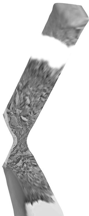
Here is a rather crudely reprojected version of the Venera 10 panorama. Once again we don't know the orientation of this map. The lander ended up on a patch of flat rocky slabs, and there seem to be similar rocky areas on each horizon, left and right. Between them are darker gravelly surfaces. The big remaining question would be - where is this in the Magellan radar image we saw earlier? I think this is in the plains, but we can't say exactly where.
#venus #venera10
#venus #venera10

Around the time of Veneras 9 and 10, Earth-based radar mapping was improving. This map is a composite of two radar datasets from this period, reprojected to the azimuthal projection I always use for global maps.
One paper was this:
Campbell, D.B. and Burns, B.A., 1980. Earth‐based radar imagery of Venus. Journal of Geophysical Research: Space Physics, 85(A13), pp.8271-8281.
The other... I think it was in Geophys. Res. Lett. but I haven't tracked it down yet.
#venus #radar

This all looks very nice, but we still don't know much about what is being seen. Take the very bright area Maxwell at the top - is it a mountain range or a canyon like Juventae Chasma on Mars? We only know it's rough. (Now we know it's a mountain) What about the dark smooth area with a bright rim west of Maxwell? Is it a plateau or a depression?. These images suggest lots of tectonic activity but interpretations are very uncertain.
#venus
#venus
The next mission to launch to Venus was NASA's Pioneer Venus mission, with two components. Here is a NASA look back on its 40th anniversary:
https://www.nasa.gov/centers-and-facilities/ames/40-years-ago-pioneers-encounter-venus/
The mission consisted of an orbiter and a multiprobe carrier, launched separately. We will deal with the orbiter first, then look at the probe mission. The image is one of many taken by the orbiter, and here are several more:
https://commons.wikimedia.org/wiki/Category:Photos_by_Pioneer_Venus_1

At first we knew absolutely nothing about the surface of Venus. Then we saw bright radar-reflective spots, but we didn't know if they were high or low or had any relief at all. It took Pioneer Venus to give us our first topographic dataset using a radar altimeter (far less precise than a laser altimeter, but lasers won't work at Venus). Here is an early map, and it comes with the first feature names. Now we can see Maxwell is a high mountain.
#venus #pioneervenus
#venus #pioneervenus

This link:
https://www.lpi.usra.edu/resources/venus_maps/
gives you lots of Venus maps by USGS, but for today we want the top one:
https://www.lpi.usra.edu/resources/venus_maps/1324/I-1324_150.jpg
The map in the previous post was hard to read but this is much clearer. There are 2 obvious continent-scale highland areas (remember Venus is about as big as Earth) Earth. 10 degrees of latitude or along the equator is approx. 1000 km for scale. The poles were not mapped, but our modern view of the planet is becoming clear.
#venus #pioneervenus

Pioneer Venus also made a very low resolution radar image of the equatorial region of Venus. If I can find it I will post it tomorrow. But let's look now at the probes it dropped into the atmosphere. There were 3 small probes, one on the day side of the terminator, one on the night side, one in the north near the Maxwell radar feature (not known during mission design). A large probe and the carrier spacecraft ('bus') also entered the atmosphere.
#venus #pioneervenus
#venus #pioneervenus
Here is a map showing their target points and actual sites. They were pretty close to the targets. These were studying the atmosphere, not the surface, and were not expected to survive landing (they just fell, no parachutes except for the large probe). However, the Day probe transmitted from the surface for over an hour and the night probe for 2 seconds (it probably fell over). The bus had instruments too and gave data until it burned up.
#venus #pioneervenus
#venus #pioneervenus

Here are a set of close-up views of the Pioneer Venus sites. First the large probe (which operated down to the surface) and the bus or carrier spacecraft which burned up in the atmosphere (having no heatshield). And surviving fragments of the bus fell in the area indicated. The close views at right (100 km across) show the large probe fell in a region of extensive lava flows and the bus broke up over over a heavily faulted region.
#venus #pioneervenus
#venus #pioneervenus

Here are the remaining 3 Pioneer Venus probe sites. Remember that these were targeted for atmospheric, not geological observations and the geology was unknown. Only the Day probe survived on the surface for any significant time. All 3 sites are lava plains crossed by ridges and fractures, a very common landform on Venus. The night probe is close to Maxwell Montes - how interesting it would be to land on top of it...
#venus #pioneervenus
#venus #pioneervenus

The temperature and pressure would be significantly lower on top of Maxwell - still hellish for us but a little bit less hellish than elsewhere, maybe allowing a longer survival time on the surface. The composition of these bright mountain tops seems to be different as well, so it would be interesting to probe it. But there are more exciting targets - the favourite goal for future landers is the tesserae (fractured uplands) which may be bits of older crust.
#venus #pioneervenus
#venus #pioneervenus
I am a cartographer, so all I want to do all day and half the night is mark things on maps. Pioneer Venus orbited Venus and eventually entered the atmosphere and burned up. The chances of anything reaching the surface are slim, but that's not the point - I would like to be able to say 'Pioneer Venus burned up over ----- Planitia, Magellan burned up over ---- Terra, Venus Express burned over --- Tessera. It should be simple, but it's not. Let's look at the problem.
#venus
#venus
These orbiters were all in quite elongated high inclination orbits, so they can only enter the atmosphere at (or near) their periapsis latitude, and we know what that is for the final phase of each mission, so the latitude is fixed quite easily. The longitude is much more complicated. The orientation of the orbit plane in space would be known. The question is, which bit of the planet was under the periapsis at the time of atmospheric entry on the last orbit?
#venus
#venus
I'm not clever enough to put all this together and answer my own question, and I have asked the internet at least once (on unmannedspaceflight.com) but to no avail. I might have an answer for Pioneer Venus so let's look at it. I jotted these notes down years ago and don't recall where my information was from. But this is what I have:
Last contact was on 8 October 1992. The last orbit was on 22 October...
#venus
Last contact was on 8 October 1992. The last orbit was on 22 October...
#venus
The periapsis was near midnight on Aug. 28, when the subsolar longitude was about 208 degrees east, so periapsis longitude was about 28 east. On the last orbit, 40 days later, the periapsis long. should be about 86 east. Therefore the place where Pioneer Venus burned up should be about 11 south (periapsis latitude) and 86 east, on the south edge of Ovda Regio (you can find it on my probe location map). I don't have similar data for other orbiters and am not confident about this one.
#venus
#venus
@PhilStooke Venera craft were sheer, dogged brilliance. Completely underappreciated, even today.