improvement idea didn't quite work out :/
The idea was that since I can determine which curve is closest to a given point on the terrain grid, I can use edge data to find the spots where abrupt changes might occur, and then can do a nearest crossing test relatively easily. This does accomplish what it is supposed to, but other artifacts show up around the perimeter of the map so it's not really worth it.
Might have to settle for blurring the height around those edge crossings instead.
still, the technique is pretty powerful even without the higher order curves, and I'm sure someone smart on here might spot a better way to blend between spline patches 🤷♀️ I'll probably write something up on my blog in the next few days time permitting.
I'm really quite amazed at how fast the geometry nodes blur intrinsic is, but I'm starting to think the perf measurement for it is just broken.
happy accident: transforming arbitrary meshes with the spline field
Experimenting with visualizing the extruded spline tangents cropped by the spline distance field volumes. This is meant to demonstrate what is being interpolated to produce the height field, though this doesn't show the part where splines are projected past their endpoints.
Today an artist friend used this technique to completely redo all of the terrain in the vertical slice level for the game she's working on. Judging by timestamps, it took her about an hour to complete after a false start. I'm not posting the screenshots because they're confidential but holy smokes it is awesome :O
what really gives me life today is she wants to push it even further <3
I've been pondering how to adapt this technique into a more general purpose modeling technique, and heh it's funny how problems are trivial when they're discrete, bounded, and 2D, but get a bit harder when they're continuous, unbounded, and 3D
oh great, the piecewise solution is a 3D voronoi diagram. of course it is 😔
I've got a distance field approximation now. Here's something I hacked together with geonodes that runs like a siggraph demo you got too excited about. I haven't implemented blending between adjacent fields yet, but I'm feeling optimistic that I'll be able to get something workable together for real time raytracing later.
The magic here is I spawn one of these for each point on the spline, aligned to that spline point's tangent plane and scaled to that spline point's radius. Then I deform each point toward the tangent plane of whichever spline field it happens to actually be in and bob's your uncle. Its got some quirks but it works surprisingly well.
Btw here's a cool trick I figured out today:
Say you have a bunch of mesh patches that overlap but the vertices don't line up, and you wanna force them to anyway.
Use the "Distribute Points on Faces" node with the "Poisson Disc" mode and a minimum distance equal to the longest edge in your triangle soup.
Then in the triangle soup, snap each vertex to the closest point in the poisson disc point cloud, merge by distance, and bam! you got something that is very almost a delaunay triangulation :3
Attempting to make a car with the 3D spline modeling technique. So far so good!
blocking out the roof and back window
This is probably as far as I get tonight, unless I get an inexplicable second wind.
So far I think this technique is agreeable for me. I've been able to pick at it a bit on and off despite being sick and tired. This technique is a more fiddly than I want it to be, but that might in part be because I'm trying to make the model accurate to my references.
Unsurprisingly I have some ideas for how to improve this technique further.
I think what I actually want is to make the feature outlines with splines (eg, the windows, the different parts of the car body, the bumper, etc) and then use those to guide the placement of control points that can then be used to further adjust the shape of the local surface, as well as to paint materials. The spline outlines would then also serve as cropping features for the control points / surfels so materials can have hard edges etc.
As for what my game is to render exactly, I'm leaning towards representing stuff authored in Blender as cropped surfel clouds that can then be raytraced to produce more different surfels. Cropped surfels would be a set of pseudo discs that occasionally also have a cropping shape associated.
In that end, anything with a mesh representation can be efficiently prepared for my game via the distribute points of faces node.
The cropped surfels thing is nice because I wont have to commit to any particular artistic work flow in Blender, and should I need some kind of acceleration structure I think the surfels could be made hierarchical be generating sets of them at different frequencies and saving out which ones overlap with which.
I think the goal I should try to work on next is just putting together a simple scene like a road with a guard rail and some cones pretending to be trees and see if I can export that into something I can render, and then figure out whether or not rendering that can be made fast.
I just wanna get lost in the surfels, man 😌
I don't like how Blender does unit conversion.
If you set a unit system, and choose a non-meter base unit for distance, it converts everything to meters under the hood, with the unit scale being a scale factor on the conversion to meters.
Since the units presented in the UI are superficial, if you need to change the scale or the base unit everything in your scene changes along with it ;_;
Anyways I just realized that I was greatly mistaken as to how this all worked several hours ago when I tried to setup the base unit and scale to be able to represent a scene a mile in diameter and thought I got to pick the base unit 😩
I picked a mile diameter for the map cell arbitrarily, but this precision problem in Blender got me thinking about this more and...
huh, I guess the view distance to the horizon is about 3 miles if you're 6 feet tall, and is a few hundred meters less if you're 5 feet tall.
now I'm trying to decide if I want to vary the draw distance based on camera elevation or if I want to deform the relative world positions of things to simulate the curvature of the earth 🤔
again way over kill for a game about driving a shitty car in the rain but on the other hand when was the last time you played a game about driving a shitty car in the rain that even attempted to let you reach out and touch the infinite
I got a bit carried away reading about classical units and what ancient people found to be useful units of measurement, and anyways it turns out the distance you can walk in an hour is in the same ball park as the distance you can see up to the horizon (for some excessively uniform and able bodied definition of "you")
What an interesting coincidence that these just happen to work out to be relatively whole numbers in both time and space.
Wild speculation here, probably completely wrong, but it wouldn't surprise me if somewhere in the distant past folks used the time it took to walk as far as you can see as a colloquial time unit and that distance as a colloquial large distance unit and through an elaborate game of telephone that eventually became the hour and league of today's units we all love and know (except for all the people the French conquered)
A continuation of this idea that I want to explore later is applying the time spent walking to the horizon thing as a perceptual unit for distance in video games, because while realistic games often use real world units for modeling things these days, they only do so at a very immediate scale, and large spaces (for good reasons) are typically much smaller than they'd be irl, and so stuff like speed has to be fudged to make it all work.
It's a problem space I know well, but looking at it from another angle is interesting to me.
somethings that might be interesting to play with: the amount of time a player takes to walk an arbitrary distance in a straight line can be used to calculate a practical unit conversion for literal distances, and the amount of time it takes for the player to walk a route between to points on the map following a natural travel route can be used to determine how big the space actually feels
oh my god blender does not consistently apply the unit scale everywhere it does the internal conversion to meters >:O
well my precision problems seem to be primarily due to poor choices made in their choice of view matrix so that's easy enough to work around at least
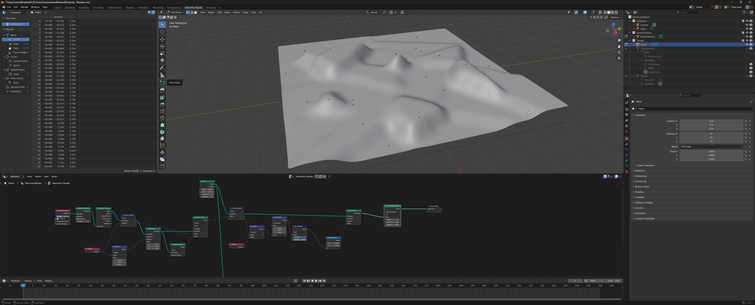
Anyways here's a mile diameter of terrain in Blender :P
Pretend this is a 2 lane rural highway that suspiciously lacks its shoulders, clear zones, and normal markings in an improbably arid mountainous region of Wisconsin and not a narrow path through cookies and cream land.
I think for map cells it'll work better if I try to keep the road connections at the crests of hills and going around bends and stuff like that, and the ideal size of a given cell is probably a function of how fast the player is expected to move through it, so when you're at the stage of the game where you're likely to travel in the 60 - 120 mph range a mile or three is probably a pretty reasonable cell diameter. the faster sections of the game will want larger map cells though
I had an idea for an interpolation strategy that doubles up as a noise function, and, well, here it is. I'm much happier with this version :3
I figure the exporter may as well build the acceleration structure for non-implicit models like landscape tiles for my game, so I'm experimenting with data structures for that now.
Here's a visualization of a hierarchical surfel graph for that landscape I posted a picture of the other day.
I'm experimenting with the graph construction parameters and visualization thereof and take my word for it that this image is actually very useful to me, but the main thing going on here is that it looks cool.